Bonython Park

Last updated

Bonython Park
Part of Tulya Wardli
Bonython Park picnic - Adelaide.jpg
Bonython Park picnic
Australia South Australia City of Adelaide location map.svg
Red pog.svg
TypePark
Location North Adelaide, South Australia
Coordinates 34°55′02″S138°34′51″E / 34.9172°S 138.5809°E / -34.9172; 138.5809
Created1837 (1837)

Bonython Park is a 17-hectare park in the north-west Park Lands of the South Australian capital of Adelaide. The park was opened in 1962 and named in honour of prominent South Australian politician and journalist, Sir John Langdon Bonython. It is situated on the north-western side of the River Torrens, bordered by Port Road. It is on the opposite side of the river to a golf course, and adjacent to the old Adelaide Gaol and the Police Barracks.

Contents

Bonython Park forms part of what is known as Park 27, and since the dual naming initiative by Adelaide City Council in the early 2000s, Park 27 is also known as Tulya Wardli. There are sites straddling this park and Park 1/ Pirltawardli of some significance to the Kaurna people, since various "native locations" were established on the sites dating from 1837, when the first settlers arrived and the establishment of a Christian mission in the following year.

History

There is some evidence to suggest that there was a billabong on the site, used as a fishing spot for the Kaurna people prior to European settlement. Following the arrival of European settlers from 1837, right through to 1914, it was used as a watering place for cattle. [1]

The site of Bonython Park was the first area occupied by Europeans, from January to March 1837. The migrants camped in tents and wooden huts in two camps, called Buffalo and Coromandel, after two of the ships of the First Fleet of South Australia. [1]

After 1837, the so-called “Native Location” was established for local Kaurna people. Bromley’s Camp, the first of these, was established in April 1837 by Captain Walter Bromley, the second interim Protector of Aborigines, on land that is now part of Bonython Park. In reality, it was little more than a rations distribution point. In August 1837, William Wyatt became the next Protector, and created a more permanent settlement south of the river. [1]

In October 1838 two German missionaries, Christian Teichelmann and Clamor Schürmann (and later Samuel Klose) arrived, setting themselves up at what became known as the "Old Location", studying the Kaurna language and teaching in that language. This was the first mission in South Australia. In 1839 the Native Location was moved again, across to the north side of the river, on what is now part of the Par 3 golf course. This was called the Pirltawardli (now the second name for Park 1 of the Park Lands), which means "possum place", also known as the "Aboriginal Location". [2]

In December 1840 a school opened, supported by Governor George Gawler, but the site was dismantled in 1845, on the orders of Governor George Grey, who thought it best to take the children away from their parents, and a new "Native School" run by the government, which taught only in English, was established near what is now Kintore Avenue. (The Native School closed in 1851, with the remaining children were taken to Poonindie Mission at Port Lincoln on the Eyre Peninsula. [2]

A few people continued to camp near the house of Klose, the only remaining missionary, at the site known as Pirltawardli. In 1846 the government build some brick sheds in part of this area, and also across the river behind the new Adelaide Gaol. One was for the "Murray tribe", who had moved to the area, and a smaller number of sheds for what was left of the "Adelaide tribe". [2]

Pirltawardli, just across the river and straddling Parks 1 and 27, is still of great significance to Kaurna people, as well as non-Indigenous South Australians. Nearly all of the recorded language and early written records of Kaurna culture stem from this place, documented by the missionaries, who also shared their views on race relations in the new colony. On 26 May 2000 a plaque was erected there commemorating its place in Adelaide’s history. [2]

Description

Bonython Park, part of Park 27/Tudla Wardli, has many points of interest and recreation within and nearby. [3]

The park hosts or has hosted several major events including the Schützenfest (a German shooting festival), the former Skyshow fireworks display, and various music festivals including Soundwave, Stereosonic and the Big Day Out. It is also the location of various visiting circuses, including Cirque du Soleil. [4]

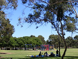
The Bonython Park Adventure Playspace, a kiosk), a model boat pond, open kick/play fields, a junior playground and multi-barbecue stations are available for the public. [3]

The "Magic Forest & Native Bee N Bee Project" is a grove of mixed eucalyptus trees planted in 1997 by the Children’s Peaceful Environment Foundation in conjunction with the Council. It includes a native bee hotel. [1]

The Roma Mitchell Garden, tended by prisoners until the closure of the gaol, has since the 1990s been maintained by the Catholic Order of Malta. [3]

See also

Related Research Articles

<span class="mw-page-title-main">Adelaide</span> Capital city of South Australia, Australia

Adelaide is the capital and largest city of South Australia, and the fifth-most populous city in Australia. "Adelaide" may refer to either Greater Adelaide or the Adelaide city centre. The demonym Adelaidean is used to denote the city and the residents of Adelaide. The traditional owners of the Adelaide region are the Kaurna. The area of the city centre and surrounding Park Lands is called Tarndanya in the Kaurna language.

<span class="mw-page-title-main">Brown Hill Creek</span> River in South Australia, Australia

Brown Hill Creek, also known as Willawilla in the Kaurna language, is a watercourse flowing from the Adelaide Hills through in the inner south suburbs of the Adelaide metropolitan area, in the Australian state of South Australia. It is part of the Patawalonga River catchment.

The Kaurna people are a group of Aboriginal people whose traditional lands include the Adelaide Plains of South Australia. They were known as the Adelaide tribe by the early settlers. Kaurna culture and language were almost completely destroyed within a few decades of the British colonisation of South Australia in 1836. However, extensive documentation by early missionaries and other researchers has enabled a modern revival of both language and culture. The phrase Kaurna meyunna means "Kaurna people".

<span class="mw-page-title-main">River Torrens</span> River in Australia

The River Torrens is the most significant river of the Adelaide Plains. It was one of the main reasons for the siting of the city of Adelaide, capital of South Australia. It flows 85 kilometres (53 mi) from its source in the Adelaide Hills near Mount Pleasant, across the Adelaide Plains, past the city centre and empties into Gulf St Vincent between Henley Beach South and West Beach. The upper stretches of the river and the reservoirs in its watershed supply a significant part of the city's water supply.

<span class="mw-page-title-main">Victoria Square, Adelaide</span> Public square in the centre of Adelaide, South Australia

Victoria Square, also known as Tarntanyangga, is the central square of five public squares in the Adelaide city centre, South Australia.

<span class="mw-page-title-main">Adelaide Gaol</span>

Adelaide Gaol is a former Australian prison located in the Park Lands of Adelaide, in the state of South Australia. The gaol was the first permanent one in South Australia and operated from 1841 until 1988. The Gaol is one of the two oldest buildings still standing in South Australia, the other being Government House which was built at the same time. The prison is now a museum, tourist attraction and function centre.

<span class="mw-page-title-main">Port River</span> Tidal estuary north of Adelaide, South Australia

The Port River is part of a tidal estuary located north of the Adelaide city centre in the Australian state of South Australia. It has been used as a shipping channel since the beginning of European settlement of South Australia in 1836, when Colonel Light selected the site to use as a port. Before colonisation, the Port River region and the estuary area were known as Yerta Bulti by the Kaurna people, and used extensively as a source of food and plant materials to fashion artefacts used in daily life.

<span class="mw-page-title-main">History of Adelaide</span>

This article details the history of Adelaide from the first human activity in the region to the 20th century. Adelaide is a planned city founded in 1836 and the capital of South Australia.

<span class="mw-page-title-main">Adelaide Park Lands</span> Parks in Adelaide

The Adelaide Park Lands comprise the figure-eight configuration of land, spanning both banks of the River Torrens between Hackney and Thebarton, which encloses and separates the City of Adelaide area from the surrounding suburbia of greater metropolitan Adelaide, the capital city of South Australia. They were laid out by Colonel William Light in his design for the city, and originally consisted of 2,300 acres (930 ha) "exclusive of 32 acres (13 ha) for a public cemetery". One copy of Light's plan shows areas for a cemetery and a Post and Telegraph Store on West Terrace, a small Government Domain and Barracks on the central part of North Terrace, a hospital on East Terrace, a Botanical Garden on the River Torrens west of North Adelaide, and a school and a storehouse south-west of North Adelaide.

The Ramindjeri or Raminjeri people were an Aboriginal Australian people forming part of the Kukabrak grouping now otherwise known as the Ngarrindjeri people. They were the most westerly Ngarrindjeri, living in the area around Encounter Bay and Goolwa in southern South Australia, including Victor Harbor and Port Elliot. In modern native title actions a much more extensive territory has been claimed.

Kaurna is a Pama-Nyungan language historically spoken by the Kaurna peoples of the Adelaide Plains of South Australia. The Kaurna peoples are made up of various tribal clan groups, each with their own parnkarra district of land and local dialect. These dialects were historically spoken in the area bounded by Crystal Brook and Clare in the north, Cape Jervis in the south, and just over the Mount Lofty Ranges. Kaurna ceased to be spoken on an everyday basis in the 19th century and the last known native speaker, Ivaritji, died in 1929. Language revival efforts began in the 1980s, with the language now frequently used for ceremonial purposes, such as dual naming and welcome to country ceremonies.

<span class="mw-page-title-main">Thebarton, South Australia</span> Suburb of Adelaide, South Australia

Thebarton, formerly Theberton, on Kaurna land, is an inner-western suburb of Adelaide, South Australia in the City of West Torrens. The suburb is bounded by the River Torrens to the north, Port Road and Bonython Park to the east, Kintore Street to the south, and South Road to the west.

German Australians are Australians with German ancestry. German Australians constitute one of the largest ancestry groups in Australia, and German is the fifth most identified European ancestry in Australia behind English, Irish, Scottish and Italian. German Australians are one of the largest groups within the global German diaspora.

<span class="mw-page-title-main">Rymill Park</span> Park in Adelaide, South Australia

Rymill Park / Murlawirrapurka, and numbered as Park 14, is a recreation park located in the East Park Lands of the South Australian capital of Adelaide. There is an artificial lake with rowboats for hire, a café, children's playground and rose garden, and the Adelaide Bowling Club is on the Dequetteville Terrace side. The O-Bahn passes underneath it, to emerge at the western side opposite Grenfell Street.

<span class="mw-page-title-main">William Wyatt (settler)</span> Settler and philanthropist in South Australia (1804–1886)

William Wyatt was an early settler and philanthropist in South Australia. He was the third interim Protector of Aborigines in the colony between 1837 and 1839, worked on documenting the Kaurna language of the local Australian Aboriginal inhabitants of Adelaide and was a member of many boards, involved with fields as diverse as education, medicine and horticulture.

<span class="mw-page-title-main">Adelaide city centre</span> Suburb of Adelaide, South Australia

Adelaide city centre is the inner city locality of Greater Adelaide, the capital city of South Australia. It is known by locals simply as "the City" or "Town" to distinguish it from Greater Adelaide and from the City of Adelaide local government area. The population was 15,115 in the 2016 census.

<span class="mw-page-title-main">Whitmore Square</span>

Whitmore Square, also known as Iparrityi, is one of five public squares in the Adelaide city centre, South Australia. Occupying 2.4ha, it is located at the junction of Sturt and Morphett streets in the south-western quarter of the Adelaide city grid.

<span class="mw-page-title-main">Matthew Moorhouse</span> English pioneer in Australia (1813–1876)

Matthew Moorhouse was an English pioneer in Australia, pastoralist, politician, and Protector of Aborigines in South Australia. He was in charge of the armed party that murdered 30-40 Maraura people, which may have included women and children, now known as the Rufus River massacre.

The Aboriginal South Australians are the Indigenous people who lived in South Australia prior to the British colonisation of South Australia, and their descendants and their ancestors. There are difficulties in identifying the names, territorial boundaries, and language groups of the Aboriginal peoples of South Australia, including poor record-keeping and deliberate obfuscation, so only a rough approximation can be given here.

<span class="mw-page-title-main">Hundred of Yatala</span> Cadastral in South Australia

The Hundred of Yatala is a cadastral unit of hundred in South Australia covering much of the Adelaide metropolitan area north of the River Torrens. It is one of the eleven hundreds of the County of Adelaide stretching from the Torrens in the south to the Little Para River in the north; and spanning from the coast in the west to the Adelaide foothills in the east. It is roughly bisected from east to west by Dry Creek. It was named in 1846 by Governor Frederick Robe, Yatala being likely derived from yartala, a Kaurna word referring to the flooded state of the plain either side of Dry Creek after heavy rain.

References

  1. 1 2 3 4 Adelaide Park Lands Preservation Association with research support from Department of the Environment, Biodiversity Conservation Division. "Bonython Park: First settlement and Kaurna significance". Adelaide City Explorer. Retrieved 7 December 2019.
  2. 1 2 3 4 Harris, Rhondda (6 February 2014). "Pirltawadli". SA History Hub (1 June 2017 (updated spelling) ed.). Retrieved 7 December 2019. ...revised version of an entry first published in The Wakefield Companion to South Australian History, edited by Wilfrid Prest, Kerrie Round and Carol Fort (Adelaide: Wakefield Press, 2001)
  3. 1 2 3 "Bonython Park/Tulya Wardli (Park 27)". Adelaide City Explorer. Curated by Adelaide Park Lands Preservation Association. Retrieved 7 December 2019.{{cite web}}: CS1 maint: others (link)
  4. Adelaide Park Lands Preservation Association with research support from Department of the Environment, Biodiversity Conservation Division. "Bonython Park circus and events site". Adelaide City Explorer. Retrieved 7 December 2019.