
Weir Wood Reservoir is a 153.5-hectare (379-acre) biological Site of Special Scientific Interest west of Forest Row in East Sussex. It is in High Weald Area of Outstanding Natural Beauty and an area of 32.6 hectares is a Local Nature Reserve which is owned by Southern Water and managed by East Sussex County Council and Southern Water.

Bisham Woods is an 86-hectare (210-acre) biological Site of Special Scientific Interest (SSSI) west of Cookham in Berkshire. The site is also a Local Nature Reserve and part of Chilterns Beechwoods Special Area of Conservation. The SSSI is part of a 153.2-hectare (379-acre) site, also called Bisham Woods, which has been owned and managed by the Woodland Trust since 1990.

Longmoor Bog is a 14-hectare (35-acre) biological Site of Special Scientific Interest north of Finchampstead in Berkshire. An area of 11.8 hectares is a Local Nature Reserve. It is part of California Country Park, which is owned and managed by Wokingham District Council.

Glebelands is Site of Borough Importance for Nature Conservation, Grade I, in Colney Hatch in the London Borough of Barnet. It is also part of the Coppett's Wood and Glebelands Local Nature Reserve.

Oak Hill Wood is a 10-hectare Local Nature Reserve (LNR) and a Site of Borough Importance for Nature Conservation Grade I, in East Barnet, London. It is owned by the London Borough of Barnet, and part of it is a 5.5-hectare nature reserve managed by the London Wildlife Trust.

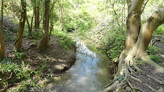
Elmbridge Open Space or Elmbridge Meadows is a Local Nature Reserve in Berrylands in the Royal Borough of Kingston upon Thames in London. It is a linear open space along the western bank of the Hogsmill River which starts at Malden Way and ends at a path between Surbiton Hill Park to Green Lane.

The Wood is a public park in Surbiton in the Royal Borough of Kingston upon Thames in London. Part of it is a bird sanctuary named after the naturalist Richard Jefferies. According to Natural England it is managed by the London Wildlife Trust, but as of August 2015 it is not on the Trust's list of sites. The 1.5-hectare site is designated as a Local Nature Reserve called 'The Wood and Richard Jefferies Bird Sanctuary'.
Hogsmill River Park or Hogsmill Valley is a linear park along the banks of the Hogsmill River in the Royal Borough of Kingston upon Thames in London. It stretches from the junction of Surbiton Hill Park and Elmbridge Avenue in Berrylands in the north to the junction between the river and a footpath to Manor Close in Old Malden in the south.
Castle Hill is a 3.5 hectare Scheduled Ancient Monument, Local Nature Reserve and Site of Borough Importance for Nature Conservation, Grade 1, in Chessington in the Royal Borough of Kingston upon Thames, London. It is owned by Merton College, Oxford, and leased to Kingston Council. The site is managed by the Lower Mole Countryside Management Project.

Linford Wood is a 3.5 hectare Local Nature Reserve in East Tilbury in Essex. It is owned and managed by Thurrock Council.

Jock's Copse is a 1.5-hectare (3.7-acre) Local Nature Reserve on the northern outskirts of Bracknell in Berkshire. It is owned and managed by Bracknell Forest Borough Council.

Tinkers Copse is a 1.9-hectare (4.7-acre) Local Nature Reserve on the northwestern outskirts of Bracknell in Berkshire. It is owned and managed by Bracknell Forest Borough Council. Along with Jock's Copse and Temple Copse it forms part of what is known locally as The Three Copses.

The Gullet is a 2.1-hectare (5.2-acre) Local Nature Reserve in Maidenhead in Berkshire. It is owned and managed by the Royal Borough of Windsor and Maidenhead.

Sutherland Grange is a 3.2-hectare (7.9-acre) Local Nature Reserve on the northern outskirts of Dedworth, a suburb of Windsor in Berkshire. It is owned and managed by the Royal Borough of Windsor and Maidenhead.
Bradnam Wood is a 12.5-hectare (31-acre) Local Nature Reserve west of Maidenhead in Berkshire. It is owned by the Royal Borough of Windsor and Maidenhead and managed by The Woodland Trust.

Braywick Park is a 12.7-hectare (31-acre) Local Nature Reserve in the Braywick suburb of Maidenhead in Berkshire. It is owned and managed by Royal Borough of Windsor and Maidenhead.

Ockwells Park is a park, part of which is a local nature reserve, in Cox Green, Berkshire, England. The nature reserve is owned by the Royal Borough of Windsor and Maidenhead.

Arthur Jacob Nature Reserve is a 4.1-hectare (10-acre) Local Nature Reserve in Horton in Berkshire. It is owned and managed by the Royal Borough of Windsor and Maidenhead.

Carpenter's Wood is a 21.4-hectare (53-acre) Local Nature Reserve west of Maidenhead in Berkshire. It is owned by the Royal Borough of Windsor and Maidenhead and managed by The Woodland Trust.

