Rowhill Nature Reserve or Rowhill Copse is a 26.6-hectare (66-acre) Local Nature Reserve (LNR) which straddles the border between Aldershot in Hampshire and Farnham in Surrey. It is owned by Rushmoor Borough Council, was declared an LNR by Waverley Borough Council and is managed by Rowhill Nature Reserve Society.
Castle Hill is a 3.5 hectare Scheduled Ancient Monument, Local Nature Reserve and Site of Borough Importance for Nature Conservation, Grade 1, in Chessington in the Royal Borough of Kingston upon Thames, London. It is owned by Merton College, Oxford, and leased to Kingston Council. The site is managed by the Lower Mole Countryside Management Project.
Castle Bottom is a British national nature reserve located near Yateley in Hampshire. It is part of Castle Bottom to Yateley and Hawley Commons, which is a Site of Special Scientific Interest, and Thames Basin Heaths Special Protection Area for the conservation of wild birds

Englemere Pond is a 26.1-hectare (64-acre) biological Site of Special Scientific Interest on the southern outskirts of North Ascot in Berkshire. The site is also a Local Nature Reserve. It is owned by the Crown Estate and managed by Bracknell Forest Borough Council.

Maiden Erlegh Lakes is a 10.2-hectare (25-acre) Local Nature Reserve Earley, a suburb of Reading in Berkshire. It is owned and managed by Earley Town Council.

Round Copse is a 1.7-hectare (4.2-acre) Local Nature Reserve in Reading in Berkshire. It is owned and managed by Reading Borough Council.

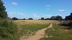
Lousehill Copse is a local nature reserve in the Tilehurst suburb of the English town of Reading. The nature reserve is 13.03 hectares in size, and is under the management of the Reading Borough Council. The majority of the site comprises natural mature woodland surrounded by housing and featuring a pond, whilst the northern section of the reserve, also known as Comparts Plantation, is a grassy meadow area. To the south the reserve is crossed by Dee Road.

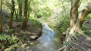
Blundells Copse is a local nature reserve in the suburb of Tilehurst in the town of Reading, UK. The site is 5.55 hectares in size, and comprises a close growing, ancient woodland with a stream. The nature reserve is under the management of the Reading Borough Council and, along with Lousehill Copse and McIlroy Park, is part of West Reading Woodlands.
Clayfield Copse is a local nature reserve on the northern edge of the suburb of Caversham in Reading, UK. The site is 8.65 hectares in size and is a natural open space consisting of fields, wild flower meadow and native woodlands adjoining the Oxfordshire countryside. Some of the woodland is being actively managed as hazel coppice, and traditional dead hedging defines some of the ancient woodland areas. The site is the only outcrop of London Clay north of the River Thames in Reading and makes up the southern tip of the Chiltern Hills. The nature reserve is under the management of the Reading Borough Council.
Loddon Nature Reserve is a 14-hectare (35-acre) nature reserve on the edge of the village of Twyford in Berkshire. It is managed by the Berkshire, Buckinghamshire and Oxfordshire Wildlife Trust.

Haymill Valley is a 7.8-hectare (19-acre) Local Nature Reserve in Slough in Berkshire. It is owned by Slough Borough Council and managed by the Berkshire, Buckinghamshire and Oxfordshire Wildlife Trust. The site is known locally as The Millie.

Farley Copse is a 3.3-hectare (8.2-acre) Local Nature Reserve on the western outskirts of Bracknell in Berkshire. It is owned and managed by Bracknell Forest Borough Council.

Jock's Copse is a 1.5-hectare (3.7-acre) Local Nature Reserve on the northern outskirts of Bracknell in Berkshire. It is owned and managed by Bracknell Forest Borough Council.

Temple Copse is a 1.9-hectare (4.7-acre) Local Nature Reserve on the northwestern outskirts of Bracknell in Berkshire. It is owned and managed by Bracknell Forest Borough Council. Along with Jock's Copse and Tinkers Copse it forms part of what is known locally as The Three Copses.

Tinkers Copse is a 1.9-hectare (4.7-acre) Local Nature Reserve on the northwestern outskirts of Bracknell in Berkshire. It is owned and managed by Bracknell Forest Borough Council. Along with Jock's Copse & Temple Copse it forms part of what is known locally as The Three Copses.

Whitegrove Copse is a 3.6-hectare (8.9-acre) Local Nature Reserve on the northern outskirts of Bracknell in Berkshire. It is owned and managed by Bracknell Forest Borough Council.

Holt Copse & Joel Park is a 5.3-hectare (13-acre) Local Nature Reserve (LNR) in Wokingham in Berkshire. It is owned by Wokingham Town Council and managed by the council and Holt Copse Conservation Volunteers.

Pearman's Copse is a 6.9-hectare (17-acre) Local Nature Reserve in Lower Earley, a suburb of Reading in Berkshire. It is owned and managed by Wokingham District Council.

Ockwells Park is a park, part of which is a local nature reserve, in Cox Green, Berkshire, England. The nature reserve is owned by the Royal Borough of Windsor and Maidenhead.