
Clay County is a county located in the far western part of U.S. state North Carolina. As of the 2020 census, the county population was 11,089. The county seat is Hayesville.

Macon County is a county located in the U.S. state of North Carolina. As of the 2020 census, the population was 37,014. Its county seat is Franklin.

The cutthroat trout(Oncorhynchus clarkii) is a fish species of the family Salmonidae native to cold-water tributaries of the Pacific Ocean, Rocky Mountains, and Great Basin in North America. As a member of the genus Oncorhynchus, it is one of the Pacific trout, a group that includes the widely distributed rainbow trout. Cutthroat trout are popular gamefish, especially among anglers who enjoy fly fishing. The common name "cutthroat" refers to the distinctive red coloration on the underside of the lower jaw. The specific name clarkii was given to honor explorer William Clark, coleader of the Lewis and Clark Expedition.

The Nantahala River is a river in western North Carolina in the United States, within the Nantahala National Forest, and near the Great Smoky Mountains National Park. Two-lane U.S. Highway 19/74 runs along the river, picnic areas dotting the route. In 1839, this was an unimproved large path, part of what became known as the Trail of Tears as the Cherokee people were forcibly removed from their homelands in this region to west of the Mississippi River and Indian Territory.
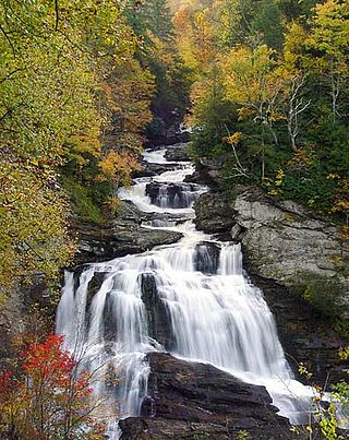
The Nantahala National Forest (/ˌnæntəˈheɪlə/), is the largest of the four national forests in North Carolina, lying in the mountains and valleys of western North Carolina. The Nantahala is the second wettest region in the country, after the Pacific Northwest. Due to its environmental importance and historical ties with the Cherokee, the forest was officially established on January 29, 1920, by President Woodrow Wilson. The word "Nantahala" is a Cherokee derived, meaning "Land of the Noonday Sun." In some spots, the sun reaches the floors of the deep gorges of the forest only when it is high overhead at midday. This was part of the homeland of the historic Cherokee and their indigenous ancestors, who have occupied the region for thousands of years.

Dick's Knob or Dicks Knob, with an elevation of 4,620 feet (1,408 m), is the third-highest peak in the State of Georgia if using a 200 ft. prominence rule. It is located in Rabun County, Georgia within the Southern Nantahala Wilderness and is the second-highest mountain in the county.

Hightower Bald, with an elevation of 4,568 feet (1,392 m) is the fourth-highest peak in the US state of Georgia. It is located in Towns County, Georgia at the North Carolina state line and is within the boundaries of the Southern Nantahala Wilderness of the Chattahoochee National Forest.

Standing Indian Mountain, elevation 5,499 feet (1,676 m), is part of the North Carolina portion of the Southern Nantahala Wilderness within the boundaries of the Nantahala National Forest. The mountain lies along the Appalachian Trail and is the highest point along the Nantahala River.

The Southern Nantahala Wilderness was designated in 1984 and currently consists of 23,473 acres (94.99 km2). Approximately 11,770 acres (47.6 km2) are located in Georgia in the Chattahoochee National Forest and approximately 11,703 acres (47.36 km2) are located in North Carolina in the Nantahala National Forest. The Wilderness is managed by the United States Forest Service and is part of the National Wilderness Preservation System. The highest elevation in the Southern Nantahala Wilderness is the 5,499-foot (1,676 m) peak of Standing Indian Mountain in North Carolina and the lowest elevation is approximately 2,400 feet (730 m). The Appalachian Trail passes through the Wilderness in both states.

The westslope cutthroat trout, also known as the black-spotted trout, common cutthroat trout and red-throated trout is a subspecies of the cutthroat trout and is a freshwater fish in the salmon family of order Salmoniformes. The cutthroat is the Montana state fish. This subspecies is a species of concern in its Montana and British Columbia ranges and is considered threatened in its native range in Alberta.

The Mountain Waters Scenic Byway is a 64.5-mile (103.8 km) National Forest Scenic Byway that traverses through the Nantahala National Forest, in Western North Carolina. It features two river gorges, hardwood forests and countryside vistas.
Lake Glenville is a reservoir located 8 miles from Cashiers, North Carolina to the dam and public beach. The headwaters, at Hurricane Creek, are less than 2 miles. It was formed by the damming of the west fork of the Tuckasegee River in 1941. Between 1951 and 2002, it was officially known as "Thorpe Reservoir" after J. E. S. Thorpe, Nantahala Power's first president. It is still listed as such on many maps. The lake bottom plunges as steeply as the mountains that meet the shore. The depth a short distance from the water's edge may register 80 feet (24 m) or more. The lake has 26 miles (42 km) of shoreline and encompasses 1450 total acres. It is a twenty-minute drive from Western Carolina University, and the town of Sylva.
Patera is a genus of land snails in the family Polygyridae.

Wesser Bald is a summit located in Macon County, North Carolina, near the community of Wesser. A wooden fire tower at the summit provides hikers with unimpeded views of the Great Smoky Mountains National Park and also the Nantahala Mountains. The Appalachian Trail traverses the summit from roughly north to south with the Nantahala Outdoor Center lying to the north within the Nantahala Gorge and Tellico gap just to the south. Tellico gap has unimproved road access. The climb from Tellico Gap takes an average of 20 minutes. Also, a third route, the blue trail, departs from the end of Wesser Creek Road and follows Wesser Creek up to a point just south of the summit to a fork with the Appalachian Trail. The summit is located at 4,627 ft (1,410 m). and is within Nantahala National Forest. A map detailing the highway routes to access Tellico Gap is available at the Nantahala Outdoor Center. Observable landforms include Wayah Bald, the Nantahala Gorge, and Clingmans Dome among others. The Wesser Fire Tower provides 360 degree views of the Smokies in a short 1.5 mile hike from Tellico Gap on the Appalachian Trail, with an elevation gain of about 767 feet. The Fire Tower was originally reported as destroyed during the forest fires which ravaged the Nantahala Forest in November, 2016 but it was later learned that it survived.
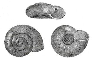
Haplotrema concavum, the gray-footed lancetooth, is a species of predatory air-breathing land snail, a terrestrial pulmonate gastropod mollusk in the family Haplotrematidae.

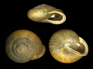
Patera clarki nantahala, the noonday globe, is a subspecies of Patera clarki, a land snail in the family Polygyridae. It is endemic to North Carolina in the United States.

Albert Mountain is a mountain in North Carolina's Nantahala Range of the Appalachian Mountains. The Appalachian Trail goes along its summit, which is around 5,200 feet (1,600 m) high. A fire tower offers views of the Blue Ridge and the Little Tennessee River valley.

Nantahala Lake is located in Macon County, North Carolina in the western part of the state. The lake is regulated and maintained by Duke Energy and is a major source of hydroelectric power to the region. Nantahala is located at 3,000 feet (910 m) in the Nantahala National Forest.

Nantahala Township is located in North Carolina, United States in the part of Macon County which is west of Wayah Gap. It has a population of 1,711. "Nantahala" is a Cherokee word which means "Land of the Noonday Sun." The area fits its name because in a few spots, the sun's rays only reaches the floors of the Nantahala National Forest when it is directly overhead during the middle of the day.

Haw Knob is a mountain located in the central Unicoi Mountains in the southeastern United States. The peak is located in Monroe County, Tennessee and Graham County, North Carolina, and has an elevation of 5,472 feet (1,668 m) above mean sea level. It located near the Cherohala Skyway and is accessible via the Benton MacKaye Trail.

