Patterson, Kansas

Last updated

Patterson, Kansas
Stouffer's Railroad Map of Kansas 1915-1918 Harvey County.png
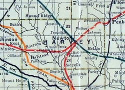
1915 Railroad Map of Harvey County
USA Kansas location map.svg
Red pog.svg
Patterson
Location within the state of Kansas
Usa edcp location map.svg
Red pog.svg
Patterson
Patterson (the United States)
Coordinates: 37°56′36″N97°39′18″W / 37.9433447°N 97.6550458°W / 37.9433447; -97.6550458 [1]
Country United States
State Kansas
County Harvey
Township Lake
Founded1888
Named for James Patterson
Elevation
[1]
1,437 ft (438 m)
Time zone UTC-6 (CST)
  Summer (DST) UTC-5 (CDT)
Area code 620
FIPS code 20-54725 [1]
GNIS ID 484647 [1]

Patterson is an unincorporated community in Harvey County, Kansas, United States. [1] It is located 5 miles south of Burrton at SW 84th St and S Patterson Rd.

Contents

History

Patterson was named for James Patterson, an early settler in Lake Township, Harvey County, Kansas. L.A. Hamlin "surveyed and laid out" the Patterson town site September 25, 1888, on land owned by Dr. Thomas S. Hunt (1830-1900) and Susan Barbee Hunt (1841-1920). [2] In 1887, Dr. Hunt deeded land for right-of-way to the Kansas Midland Railroad Company. He developed the town and sold building lots. Patterson became a station on a railroad segment of St. Louis–San Francisco Railway that ran from Wichita to Burrton. Two passenger trains a day passed through Patterson.

A post office was opened in Patterson in 1888, and remained in operation until it was discontinued in 1927. [3]

The community was located along a railroad line between Burrton and Bentley, but the track was removed in the 1990s or 2000s. [4]

Geography

Patterson is located at coordinates 37.9433447, -97.6550458 in the state of Kansas. [1]

Education

The community is served by Burrton USD 369 public school district.

Related Research Articles

<span class="mw-page-title-main">Marion County, Kansas</span> County in Kansas, United States

Marion County is a county located in the U.S. state of Kansas. Its county seat is Marion and its most populous city is Hillsboro. As of the 2020 census, the county population was 11,823. The county was named in honor of Francis Marion, a brigadier general of the American Revolutionary War, known as the "Swamp Fox".

<span class="mw-page-title-main">Harvey County, Kansas</span> County in Kansas, United States

Harvey County is a county located in the U.S. state of Kansas. Its county seat and most populous city is Newton. As of the 2020 census, the county population was 34,024. The county was named for James Harvey, a U.S. senator and 5th governor of Kansas.

<span class="mw-page-title-main">Burrton, Kansas</span> City in Harvey County, Kansas

Burrton is a city in Harvey County, Kansas, United States. It is named after Isaac T. Burr, former vice-president of the Atchison, Topeka and Santa Fe Railway. As of the 2020 census, the population of the city was 861.

<span class="mw-page-title-main">Walton, Kansas</span> City in Harvey County, Kansas

Walton is a city in Harvey County, Kansas, United States. It is named in honor of one of the 19th century stockholders of Atchison, Topeka and Santa Fe Railway. As of the 2020 census, the population of the city was 219.

<span class="mw-page-title-main">Florence, Kansas</span> City in Marion County, Kansas

Florence is a city in Marion County, Kansas, United States. The city was named after the daughter of the third Governor of Kansas Samuel J. Crawford. As of the 2020 census, the population of the city was 394. It is located at the intersection of U.S. Route 50 and U.S. Route 77 highways.

<span class="mw-page-title-main">Bendena, Kansas</span> Unincorporated community in Doniphan County, Kansas

Bendena is an unincorporated community in Doniphan County, Kansas, United States. As of the 2020 census, the population of the community and nearby areas was 117.

<span class="mw-page-title-main">Elmo, Kansas</span> Unincorporated community in Dickinson County, Kansas

Elmo is an unincorporated community in Dickinson County, Kansas, United States. Elmo is located 15 miles (24 km) south of Abilene at the northwest corner of K-15 and K-4.

Stilwell is an unincorporated community in Johnson County, Kansas, United States, and part of the Kansas City metropolitan area. The ZIP Code for Stilwell is 66085.

<span class="mw-page-title-main">Beaumont, Kansas</span> Unincorporated community in Butler County, Kansas

Beaumont is an unincorporated community in Butler County, Kansas, United States. As of the 2020 census, the population of the community and nearby areas was 36.

<span class="mw-page-title-main">Annelly, Kansas</span> Ghost town in Harvey County, Kansas

Annelly is a ghost town in Richland Township 9 miles southeast of Newton in Harvey County, Kansas, United States. The community was located along the Missouri Pacific Railroad line between Newton and Whitewater, but the track was abandoned in 2003. As of 2020, the land is privately owned farmland.

<span class="mw-page-title-main">Peck, Kansas</span> Unincorporated community in Sedgwick and Sumner Counties of Kansas

Peck is an unincorporated community on the Sedgwick and Sumner County border in Kansas, United States. As of the 2020 census, the population of the community and nearby areas was 162. It is located about 2 miles west of the Kansas Star Casino at Meridian Ave and 119th St S, next the Union Pacific Railroad.

<span class="mw-page-title-main">Kackley, Kansas</span> Unincorporated community in Republic County, Kansas

Kackley is an unincorporated community in Republic County, Kansas, United States. It is located southeast of Courtland at Co Rd 5 and K-148 highway.

<span class="mw-page-title-main">Burrton Township, Harvey County, Kansas</span> Township in Kansas, United States

Burrton Township is a township in Harvey County, Kansas, United States. As of the 2000 census, its population was 1,143.

<span class="mw-page-title-main">Aulne, Kansas</span> Unincorporated community in Marion County, Kansas

Aulne is an unincorporated community in Marion County, Kansas, United States. The Aulne name was suggested by officials of the railroad when it was built through Aulne during the 19th century. It is located southwest of Marion at the intersection of Pawnee Road and 140th Street next to the Union Pacific Railroad.

<span class="mw-page-title-main">Saffordville, Kansas</span> Unincorporated community in Chase County, Kansas

Saffordville is an unincorporated community in Chase County, Kansas, United States. It is located about half way between Strong City and Emporia near the intersection of U.S. Route 50 highway and Zz Rd. BNSF Railway passes through it.

<span class="mw-page-title-main">Furley, Kansas</span> Unincorporated community in Sedgwick County, Kansas

Furley is an unincorporated community in Sedgwick County, Kansas, United States. As of the 2020 census, the population of the community and nearby areas was 39. It is located northwest of the intersection of Greenwich Road and 101st Street N, along the Union Pacific Railroad.

<span class="mw-page-title-main">McLain, Kansas</span> Unincorporated community in Harvey County, Kansas

McLain is an unincorporated community in Harvey County, Kansas, United States. Various maps and documents have listed the name as McLain, McLains, McLain's, and McClain. It is located a few miles southeast of Newton at the intersection of SE 36th St and S Woodlawn Rd.

<span class="mw-page-title-main">Putnam, Kansas</span> Unincorporated community in Harvey County, Kansas

Putnam is an unincorporated community in Harvey County, Kansas, United States. It is located southwest of Newton at the intersection of West Road and SW 60th Street, along the BNSF Railway.

<span class="mw-page-title-main">Waldeck, Kansas</span> Ghost town in Marion County, Kansas

Waldeck is a ghost town in Marion County, Kansas, United States. It is currently a ghost town that was located approximately 3.5 miles north of Lehigh next to a railroad. No buildings remain of this former community.

Kingston is an unincorporated community located in Hunt County, Texas, United States. Kingston is probably best known as the birthplace of Audie Murphy.

References

  1. 1 2 3 4 5 6 "Patterson, Kansas", Geographic Names Information System , United States Geological Survey, United States Department of the Interior
  2. As recorded by the hand of Dr. Thomas S. Hunt in his ledger.
  3. "Kansas Post Offices, 1828-1961 (archived)". Kansas Historical Society. Archived from the original on October 9, 2013. Retrieved June 11, 2014.
  4. Abandoned Railroad; abandonedrails.com

Further reading