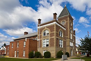
Mineral County is a county in the U.S. state of West Virginia. It is part of the Cumberland metropolitan area, together with Cumberland, Maryland. As of the 2020 census, the population was 26,938. Its county seat is Keyser. The county was founded in 1866.
Fort Ashby is a census-designated place (CDP) in Mineral County, West Virginia, United States, along Patterson Creek. It is part of the Cumberland, MD-WV Metropolitan Statistical Area. The population was 1,380 at the 2010 census. The community was originally chartered as Frankfort and then known as Alaska before it took the name of its well-known historic landmark. Fort Ashby is the location of the Mineral County Fair.

The West End is a part of Richmond, Virginia. Definitions of the bounds of the West End vary, it may include only the western part of the city of Richmond or extend as far as western Henrico County. As there is no one municipal organization that represents this specific region, the boundaries are loosely defined as being north of the James River, west of I-195, and south of Broad Street. Historically, the Richmond neighborhoods of the Fan and the Museum District were a part of the West End. A primary conduit through the West End is Interstate 64.
Burlington is a census-designated place (CDP) in Mineral County, West Virginia, United States, located along U.S. Route 50 where it crosses Pattersons Creek. As of the 2020 census, its population was 131. It is part of the Cumberland, MD-WV Metropolitan Statistical Area.
Headsville is an unincorporated community in Mineral County, West Virginia, United States. It is part of the Cumberland, MD-WV Metropolitan Statistical Area. It lies between U.S. Route 50 and West Virginia Route 46 alongside Pattersons Creek.
Patterson Creek Mountain is a mountain ridge that forms the border between Mineral and Hampshire counties and Grant and Hardy Counties in West Virginia's Eastern Panhandle. The mountain's namesake, Patterson Creek, parallels its western flank. The southern end of the Patterson Creek Mountain is near the confluence of Lunice Creek and the South Branch Potomac River and its northern end is located southwest of Springfield. The mountain reaches its highest elevation at Charles Knob.

Mill Creek is a 14.0-mile-long (22.5 km) tributary stream of the South Branch Potomac River, belonging to the Potomac River and Chesapeake Bay watersheds. The stream is located in Hampshire County in West Virginia's Eastern Panhandle. Mill Creek flows into the South Branch west of Romney Bridge near Vanderlip along the Northwestern Turnpike.
Forman is an unincorporated community on Patterson Creek in Grant County, West Virginia, United States.
Greenland is an unincorporated community between Walker's Ridge and New Creek Mountain on the North Fork Patterson Creek in Grant County, West Virginia, United States. Greenland lies at the western end of Greenland Gap in New Creek Mountain.
Lahmansville is an unincorporated community on Patterson Creek in Grant County, West Virginia, United States, located along West Virginia Secondary Route 5 at its junction with Secondary Route 5/6.
Medley is an unincorporated community on Patterson Creek in Grant County, West Virginia, United States.
Williamsport is an unincorporated community on Patterson Creek in Grant County, West Virginia, United States. Williamsport is the birthplace of J.R. Clifford (1848-1933), West Virginia's first African-American attorney.
Champwood is an unincorporated community on Patterson Creek in Mineral County, West Virginia, United States. It is part of the 'Cumberland, MD-WV Metropolitan Statistical Area'. Champwood lies along West Virginia Route 46.
Russelldale is an unincorporated community in Mineral County, West Virginia, United States. Russelldale is located on Patterson Creek Mountain to the east of Patterson Creek.
Mill Creek is an 8.7-mile-long (14.0 km) tributary stream of Patterson Creek in Mineral County, West Virginia. It is also known as Mill Run.

U.S. Route 50 in West Virginia runs from the border with Ohio to Virginia, passing briefly through Garrett County, Maryland, and following the Northwestern Turnpike. Prior to the U.S. Highway System it was West Virginia Route 1 and in the 1930s, the road was not finished in Maryland. Today the section of US 50 from Clarksburg to Parkersburg on the Ohio River is part of Corridor D of the Appalachian Development Highway System.

Shepherd Hall, also known as Monument Place and formerly as Stone Mansion, is a historic house listed on the National Register of Historic Places in the city of Wheeling in the U.S. state of West Virginia. It is located in the Elm Grove area of Wheeling, Ohio County, West Virginia.
Hot Coal or Hotcoal was an unincorporated community and coal town located along the Winding Gulf Creek in Raleigh County, West Virginia, United States. Originally, it was named Patterson and later acquired the name Hot Coal. It was the next community past Big Stick on County Route 3/2. Although, the community now no longer exists, the Winding Gulf Bank, now the National Bank at Beckley, resided at Hot Coal and was moved to Beckley on January 1, 1914. Hot Coal at one time had a Post Office
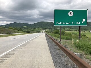
Patterson Creek is a 51.2-mile-long (82.4 km) tributary of the North Branch Potomac River in West Virginia's Eastern Panhandle, in the United States. It enters the North Branch east of Cumberland, Maryland, with its headwaters located in Grant County, West Virginia. Patterson Creek is the watershed for two-thirds of Mineral County, West Virginia. The creek passes through Lahmansville, Forman, Medley, Williamsport, Burlington, Headsville, Reeses Mill, Champwood, and Fort Ashby.
The Devonian Needmore Formation or Needmore Shale is a mapped bedrock unit in Pennsylvania, Maryland, Virginia, and West Virginia.


