Paultown | |
|---|---|
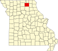
 Paultown Location of Paultown in Missouri  Paultown Paultown (the United States) | |
| Coordinates: 40°09′38″N92°21′54″W / 40.160556°N 92.365000°W | |
| Country | United States |
| State | Missouri |
| County | Adair County |
| Time zone | UTC-6 (Central Standard Time) |
| • Summer (DST) | UTC-5 (Central Daylight Time) |
Paultown (also known as Paulville) is an unincorporated community in eastern Adair County, in the U.S. state of Missouri. [1] The community was approximately one mile northeast of Brashear and the Paultown Cemetery is about one-half mile to the east above Big Deer Branch. [2]