Nineveh Township, Missouri | |
|---|---|
 | |
| Coordinates: 40°15′21″N092°41′50″W / 40.25583°N 92.69722°W | |
| Country | United States |
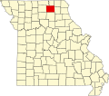
| State | Missouri |
| County | Adair |
| Area | |
• Total | 54.41 sq mi (140.93 km2) |
| • Land | 54.28 sq mi (140.58 km2) |
| • Water | 0.14 sq mi (0.35 km2) 0.25% |
| Elevation | 804 ft (245 m) |
| Population (2010) | |
• Total | 1,289 |
| • Density | 24/sq mi (9.2/km2) |
| FIPS code | 29-52526 [2] |
| GNIS feature ID | 0766214 |
Nineveh Township is one of ten townships in Adair County, Missouri, United States. As of the 2010 census, its population was 1,289. [3] It contains the census-designated place of Connelsville. The township is named from the town of Nineveh, a German communistic colony that was established in the area in about 1850. [4]