Connelsville, Missouri | |
|---|---|
 | |
| Coordinates: 40°16′39″N92°42′01″W / 40.27750°N 92.70028°W | |
| Country | |
| State | |
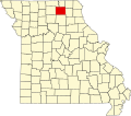
| County | Adair |
| Township | Nineveh |
| Established | 1902 |
| Area | |
• Total | 0.33 sq mi (0.86 km2) |
| • Land | 0.33 sq mi (0.86 km2) |
| • Water | 0.00 sq mi (0.00 km2) |
| Elevation | 804 ft (245 m) |
| Population (2020) | |
• Total | 53 |
| • Density | 160.12/sq mi (61.76/km2) |
| FIPS code | 29-16138 |
| GNIS feature ID | 2804677 [2] |
Connelsville is an unincorporated community in Nineveh Township, Adair County, Missouri, United States. [2] The community is on Missouri Route 149 about three miles north of Novinger and eight miles northwest of Kirksville. Shuteye Creek flows past the north side of the town and its confluence with the Chariton River is about one mile to the east. [3]