Paxton Township, Ross County, Ohio

Last updated

Paxton Township, Ross County, Ohio
Rockhold Mound.JPG
Map of Ross County Ohio Highlighting Paxton Township.png
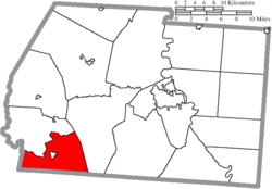
Location of Paxton Township in Ross County
Coordinates: 39°13′37″N83°16′15″W / 39.22694°N 83.27083°W / 39.22694; -83.27083
Country United States
State Ohio
County Ross
Area
  Total
31.8 sq mi (82.4 km2)
  Land31.7 sq mi (82.2 km2)
  Water0.077 sq mi (0.2 km2)
Elevation
[1]
810 ft (247 m)
Population
 (2020) [2]
  Total
1,918
  Density60/sq mi (23.3/km2)
Time zone UTC-5 (Eastern (EST))
  Summer (DST) UTC-4 (EDT)
FIPS code 39-61308 [3]
GNIS feature ID1086902 [1]

Paxton Township is one of the sixteen townships of Ross County, Ohio, United States. The 2020 census found 1,918 people in the township.

Contents

Geography

Located in the southwestern corner of the county, it borders the following townships:

The village of Bainbridge is located in central Paxton Township.

Name and history

It is the only Paxton Township statewide. [4]

Government

The township is governed by a three-member board of trustees, who are elected in November of odd-numbered years to a four-year term beginning on the following January 1. Two are elected in the year after the presidential election and one is elected in the year before it. There is also an elected township fiscal officer, [5] who serves a four-year term beginning on April 1 of the year after the election, which is held in November of the year before the presidential election. Vacancies in the fiscal officership or on the board of trustees are filled by the remaining trustees.

Education

Bainbridge Elementary School (now a preschool) is in Bainbridge, and the Paint Valley High School falls within the township.

References

  1. 1 2 "US Board on Geographic Names". United States Geological Survey. October 25, 2007. Retrieved January 31, 2008.
  2. "Paxton township, Ross County, Ohio - Census Bureau Profile". United States Census Bureau. Retrieved August 15, 2023.
  3. "U.S. Census website". United States Census Bureau . Retrieved January 31, 2008.
  4. "Detailed map of Ohio" (PDF). United States Census Bureau. 2000. Retrieved February 16, 2007.
  5. §503.24, §505.01, and §507.01 of the Ohio Revised Code. Accessed 4/30/2009.