Paxtonville, Pennsylvania

Last updated

Paxtonville
CDP
USPO Paxtonville, PA 17861.jpg
Post office
USA Pennsylvania location map.svg
Red pog.svg
Paxtonville
Location within the U.S. state of Pennsylvania
Coordinates: 40°46′14″N77°5′8″W / 40.77056°N 77.08556°W / 40.77056; -77.08556
Country United States
State Pennsylvania
County Snyder
Township Franklin
Area
[1]
  Total0.88 sq mi (2.27 km2)
  Land0.87 sq mi (2.26 km2)
  Water0.00 sq mi (0.01 km2)
Population
 (2020) [2]
  Total314
  Density359.68/sq mi (138.94/km2)
Time zone UTC-5 (Eastern (EST))
  Summer (DST) UTC-4 (EDT)
FIPS code 42-58536

Paxtonville is a census-designated place (CDP) in Franklin Township, Snyder County, Pennsylvania, United States. The population was 221 at the 2000 census.

Contents

Map of Snyder County, Pennsylvania with Municipal Labels showing Boroughs (red), Townships (white), and Census-designated places (blue). Paxtonville is located in the center. Map of Snyder County Pennsylvania With Municipal and Township Labels.png
Map of Snyder County, Pennsylvania with Municipal Labels showing Boroughs (red), Townships (white), and Census-designated places (blue). Paxtonville is located in the center.

Geography

Paxtonville is located at 40°46′14″N77°5′8″W / 40.77056°N 77.08556°W / 40.77056; -77.08556 (40.770448, -77.085661). [3]

According to the United States Census Bureau, the CDP has a total area of 0.9 square miles (2.3 km2), all land.

Demographics

Historical population
CensusPop.Note
2020 314
U.S. Decennial Census [4]

As of the census [5] of 2000, there were 221 people, 92 households, and 64 families residing in the CDP. The population density was 234.9 inhabitants per square mile (90.7/km2). There were 97 housing units at an average density of 103.1 per square mile (39.8/km2). The racial makeup of the CDP was 100.00% White.

There were 92 households, out of which 29.3% had children under the age of 18 living with them, 57.6% were married couples living together, 7.6% had a female householder with no husband present, and 30.4% were non-families. 29.3% of all households were made up of individuals, and 17.4% had someone living alone who was 65 years of age or older. The average household size was 2.40 and the average family size was 2.95.

In the CDP, the population was spread out, with 24.9% under the age of 18, 7.7% from 18 to 24, 25.8% from 25 to 44, 24.9% from 45 to 64, and 16.7% who were 65 years of age or older. The median age was 39 years. For every 100 females, there were 95.6 males. For every 100 females age 18 and over, there were 93.0 males.

The median income for a household in the CDP was $37,917, and the median income for a family was $43,594. Males had a median income of $25,000 versus $21,932 for females. The per capita income for the CDP was $14,376. About 4.6% of families and 4.9% of the population were below the poverty line, including 4.8% of those under the age of eighteen and 14.5% of those 65 or over.

History

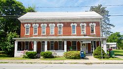
The village of Paxtonville lies on Middle Creek and is connected to Middleburg, Koonhunter and Beavertown by the Paxtonville Road. Before the road existed connecting the main street, Paxton Street, to Route 522, in use today, the main route ran along the north side of Middle Creek to Royer's Bridge. Settled in the late 18th century, it was first known as Kern's Mill and was renamed after Robert Paxton. Just after the Civil War, an iron furnace was built there, but fell into disuse after a relatively short period of time when richer ores were found in the Great Lakes region. In the early years of the 20th century, brick-making was a major industry; this ended in the summer of 1963 when fire destroyed the Paxton Brick Company. A water-powered sawmill and cider press were in operation circa 1900. At various times businesses included a creamery, a restaurant, a cigar factory, a shirt factory, one or two general stores, a movie house, a barbershop, a grist mill and a gunsmith. As of December 2007, the town boasted a church and a feed mill, as well as a community center. The building housing the community center was previously a two-room school house in which instruction was provided for grades 1 through 8. Its last use for this purpose was in the Spring of 1955; after this time pupils were bussed to Middleburg. Around 1890 a school building stood on the north-east corner of Mill Street and the Paxtonville Road.

The soil underlying the village is principally glacial till, but approximately 150 feet west and 50 feet south of the juncture of the Paxtonville Road and Paxton Street, sedimentary rock lies just beneath the soil surface. Stone American Indian artifacts, chiefly arrow and spear points, are to be found at the north edge of town near the bank of Middle Creek. The completion of the Sunbury and Lewistown Railroad in the 1870s connected Paxtonville with these two cities, and for many years a number of daily passenger trains stopped at the Paxtonville station, which was located near the creek. Passenger service ended in the late 1920s, although freight service to Paxtonville area continued into the 1960s. For a short period of time, toward the end of the 19th century, Paxtonville was shown on railroad maps as "Benfer." A number of the oldest houses are log, but this construction is not evident because they have frame or shingle siding; they date from the early 19th century. As of 2007 there stands on the south side of Maple Avenue, approximately 100 feet west of the intersection with Paxton Street, a house of unusual construction. Built by Gabriel Gill in about 1885, it lacks a frame, but the exterior walls serve this purpose, being constructed of three layers of one inch planks, with the middle layer running at a 90-degree angle to the other two which is one form of vertical plank wall construction.

Over the years most residents have been of Pennsylvania-Dutch ancestry, as witnessed by family names such as Gill, Gift, Graybill, Hassinger, Kerstetter, Oldt, Olmstead/Umstead, Musser, Shaffer, Straub, Walter, and Wenrich. Circa 1900, the cemetery was moved from its position behind the church on the east edge of the village to its modern location on the southwestern edge. Coffins and their contents were carried on horse-drawn wagons. Immediately after World War I, donations from townspeople allowed the construction of the Memorial Hall on the west side of Paxton Street. It served a number of functions, including showing movies. During the era of silent films, these were accompanied by the Paxtonville Orchestra.

Related Research Articles

<span class="mw-page-title-main">Cottonwood, California</span> Census-designated place in the United States

Cottonwood is a census-designated place (CDP) in Shasta County, California, United States. Its population is 6,268 as of the 2020 census, up from 3,316 from the 2010 census. Cottonwood was a stagecoach town where a settlement was established in 1849. The first Post Office was opened in 1852. Cottonwood is equidistant between Redding and Red Bluff, 15 miles (24 km) in either direction. It is 4 miles (6.4 km) south of Anderson.

<span class="mw-page-title-main">Hunter's Creek, Florida</span> Census-designated place in Florida, United States

Hunter's Creek is a master planned, unincorporated community and census-designated place in Orange County, Florida, United States. It is part of the Orlando–Kissimmee–Sanford, Florida Metropolitan Statistical Area. The population was 14,321 at the 2010 census. It has grown up around a large planned community named Hunter's Creek, though the CDP name given by the United States Census Bureau lacks the apostrophe.

<span class="mw-page-title-main">Douds, Iowa</span> CDP in Iowa, United States

Douds is a census-designated place (CDP) in Van Buren County, Iowa, United States. The population was 156 at the 2020 census.

<span class="mw-page-title-main">Leando, Iowa</span> CDP in Iowa, United States

Leando is a census-designated place (CDP) in Van Buren County, Iowa, United States. The population was 135 at the 2000 census.

<span class="mw-page-title-main">Ballenger Creek, Maryland</span> Census-designated place in Maryland

Ballenger Creek is an unincorporated community and census-designated place (CDP) in Frederick County, Maryland, United States. It is a part of the Frederick, Maryland urban area and is adjacent to Frederick's southern city limits. The CDP had a 2010 census population of 18,274.

La Fargeville is a hamlet and census-designated place (CDP) in the town of Orleans in Jefferson County, New York, United States. The population was 733 at the 2020 census. The hamlet is named after John Frederick La Farge, one of the early proprietors of the town. La Fargeville was once a village, but dissolved its municipal corporation in 1922.

Schlusser is a census-designated place (CDP) in North Middleton and Middlesex townships, Cumberland County, Pennsylvania, United States. The population was 5,265 at the 2010 census. It is part of the Harrisburg–Carlisle Metropolitan Statistical Area.

<span class="mw-page-title-main">Dauphin, Pennsylvania</span> Borough in Pennsylvania, United States

Dauphin is a borough in Dauphin County, Pennsylvania, United States. The population was 796 at the 2020 census. Dauphin's ZIP code is 17018. It is part of the Harrisburg–Carlisle Metropolitan Statistical Area.

<span class="mw-page-title-main">Linglestown, Pennsylvania</span> Census-designated place in Pennsylvania, United States

Linglestown is a census-designated place (CDP) in Lower Paxton Township, Dauphin County, Pennsylvania, United States. It was founded and laid out in 1765 by Thomas Lingle.

<span class="mw-page-title-main">Paxtonia, Pennsylvania</span> Census-designated place in Pennsylvania, United States

Paxtonia is an unincorporated community and census-designated place (CDP) in Lower Paxton Township, Dauphin County, Pennsylvania, United States. The population was 5,412 at the 2010 census. It is part of the Harrisburg–Carlisle Metropolitan Statistical Area.

<span class="mw-page-title-main">Reedsville, Pennsylvania</span> Census-designated place in Pennsylvania, United States

Reedsville is a census-designated place (CDP) in the Kishacoquillas Valley of Mifflin County, Pennsylvania, United States. The population was 641 at the 2010 census. Reedsville has a high Amish population.

<span class="mw-page-title-main">Middleburg, Pennsylvania</span> Borough in Pennsylvania, United States

Middleburg is a borough in Snyder County, Pennsylvania, United States. Located in Central Pennsylvania's Susquehanna River Valley, the borough's population was 1,325 at the 2020 census. It is the county seat of Snyder County. Middleburg is part of the Selinsgrove, PA Micropolitan Statistical Area, and is also part of the larger Bloomsburg-Berwick-Sunbury, PA Combined Statistical Area.

<span class="mw-page-title-main">Mount Pleasant Mills, Pennsylvania</span> CDP in Pennsylvania, United States

Mount Pleasant Mills is a census-designated place (CDP) in Snyder County, Pennsylvania, United States. The population was 342 at the 2000 census.

<span class="mw-page-title-main">Penns Creek, Pennsylvania</span> CDP in Pennsylvania, United States

Penns Creek is a census-designated place (CDP) in Snyder County, Pennsylvania.

<span class="mw-page-title-main">Barton Creek, Texas</span> CDP in Texas, United States

Barton Creek is a census-designated place (CDP) in Travis County, Texas, United States. As of the 2020 census, the CDP population was 3,356.

<span class="mw-page-title-main">Wilder, Vermont</span> Census-designated place in Vermont, United States

Wilder is an unincorporated village and census-designated place (CDP) within the town of Hartford in Windsor County, Vermont, United States. It is the location of the Wilder Dam on the Connecticut River. The population of the CDP was 1,690 at the 2010 census. The village center is an early example of a planned mill community, and was listed on the National Register of Historic Places as the Wilder Village Historic District in 1999.

<span class="mw-page-title-main">West Springfield, Virginia</span> Census-designated place in Virginia, United States

West Springfield is a census-designated place (CDP) in Fairfax County, Virginia, United States. The population was 23,369 at the 2020 census.

<span class="mw-page-title-main">Aberdeen Gardens, Washington</span> CDP in Washington, United States

Aberdeen Gardens is a census-designated place (CDP) in Grays Harbor County, Washington, United States. The population was 279 at the 2010 census.

Anderson Mill is a neighborhood of Austin and a former census-designated place (CDP) in Travis and Williamson counties in the U.S. state of Texas. The population was 7,199 at the 2010 census.

<span class="mw-page-title-main">Middlebury (CDP), Vermont</span> Census-designated place in Vermont, United States

Middlebury is the main settlement in the town of Middlebury in Addison County, Vermont, United States, and a census-designated place (CDP). The population was 7,304 at the 2020 census, out of a total population of 9,152 in the town of Middlebury. Most of the village is listed on the National Register of Historic Places as the Middlebury Village Historic District.

References

  1. "ArcGIS REST Services Directory". United States Census Bureau. Retrieved October 12, 2022.
  2. "Census Population API". United States Census Bureau. Retrieved October 12, 2022.
  3. "US Gazetteer files: 2010, 2000, and 1990". United States Census Bureau. February 12, 2011. Retrieved April 23, 2011.
  4. "Census of Population and Housing". Census.gov. Retrieved June 4, 2016.
  5. "U.S. Census website". United States Census Bureau . Retrieved January 31, 2008.