
Chesham is a market town and civil parish in Buckinghamshire, England. It is 11 miles (18 km) south-east of the county town of Aylesbury and 25.8 miles (41.5 km) north-west of Charing Cross, central London, and is part of the London commuter belt. It is in the Chess Valley and surrounded by farmland. The earliest records of Chesham as a settlement are from the second half of the 10th century although there is archaeological evidence of people in this area from around 8000 BC. Henry III granted the town a royal charter for a weekly market in 1257.
The Chiltern Hills is a chalk escarpment in England.

Great Missenden is an affluent village with approximately 2,000 residents in the Misbourne Valley in the Chiltern Hills in Buckinghamshire, England, situated between the towns of Amersham and Wendover, with direct rail connections to London Marylebone. It closely adjoins the village of Little Kingshill, and is a mile from Little Missenden and the larger village Prestwood. The narrow and historic High Street is bypassed by the main A413 London to Aylesbury Road. It is located in the heart of the Chilterns Area of Outstanding Natural Beauty. The source of the Misbourne is to be found just north of the village, although the upper reach of the river runs only in winter and the perennial head is in Little Missenden. The village is now best known as home to the late Roald Dahl, the world-famous Adult and Children's author.

Asheridge is a small hamlet in the parish of Chartridge, in Buckinghamshire, England. Prior to 1898 it was part of Chesham parish. It is situated in the Chiltern Hills, about two and a half miles north west of Chesham, 5 miles from Great Missenden and 6 miles from Wendover.

Bellingdon is a village in the civil parish of Chartridge, in Buckinghamshire, England. The name deriving from the Anglo Saxon Bellingdenu or Bella's Valley, and is recorded as Belenden in the 15th century. It is arranged along a ridge, typical of the Chiltern Hills to the north of Chesham.

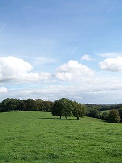
Chartridge is a village in Buckinghamshire, England situated 2 miles North West of Chesham.
Hawridge, is a small village in the Chilterns in the county of Buckinghamshire, England and bordering the county boundary with Hertfordshire. It is 3 miles (4.8 km) from Chesham, 4 miles (6.4 km) from both Tring and Berkhamsted. Hawridge is one of four villages comprising Cholesbury-cum-St Leonards, a civil parish within Chiltern District.

Hundridge is a hamlet in the parish of Chartridge, in Buckinghamshire, England. It is located in the Chiltern Hills to the west of the town of Chesham. During the 14th century it was known as Hunderugge, and Hundrige in the 15th/16th century. The hamlet name derives from either the Anglo Saxon hunda-hrycg meaning 'hounds' ridge', or from Hundan-hrycg meaning 'Hunda's ridge'.

Shackleford is a village and civil parish in the Borough of Guildford, Surrey, England centred to the west of the A3 between Guildford and Petersfield 32 miles (51 km) southwest of London and 5.2 miles (8.4 km) southwest of Guildford. Shackleford includes the localities of Eashing, Hurtmore, Norney and Gatwick.
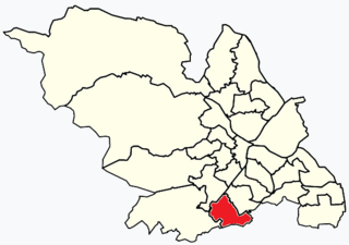
Beauchief and Greenhill ward—which includes the districts of Batemoor, Beauchief, Chancet Wood, Greenhill, Jordanthorpe, and Lowedges—is one of the 28 electoral wards in City of Sheffield, England. It is located in the southern part of the city and covers an area of 2.4 square miles (6.2 km2). The population of this ward in 2016 was estimated to be 19,669 people in 9,209 houses.

Birstall is a large village and civil parish within the Charnwood borough of Leicestershire, England. It is three miles north of Leicester city centre and is part of the wider Leicester Urban Area.

South Stoke is a village and civil parish on an east bank of the Thames, about 1.5 miles (2.4 km) north of Goring-on-Thames in South Oxfordshire. It includes less than 1 mile (1.6 km) to its north the hamlet and manor house of Littlestoke.

Easby is a hamlet and civil parish in the Richmondshire district of North Yorkshire, England. It is situated near Richmond on the banks of the River Swale, approximately 12 miles (19 km) north west from the county town of Northallerton. The population taken by ONS was less than 100. Population information is included in the parish of Hudswell.

The Home Park, previously known as the Little Park, is a private 655-acre (265 ha) Royal park, administered by the Crown Estate. It lies on the eastern side of Windsor Castle in the town and former civil parish of Windsor in the English county of Berkshire. To its south is Windsor Great Park.

Offley is a civil parish in the English county of Hertfordshire, between Hitchin and Luton. The main village is Great Offley, and the parish also contains the nearby hamlets of Little Offley and The Flints. In the south-west of the parish, near Luton, there are the hamlets of Cockernhoe, Mangrove Green and Tea Green, and also the Putteridge Bury estate; these have LU2 postcodes and 01582 telephone numbers.

Chesham Urban District was from 1894 to 1974 a local government district in the administrative county of Buckinghamshire, England. The urban district took over the responsibilities of the disbanded Chesham Local Government District.
Thirkleby High and Low with Osgodby is a civil parish in the Hambleton district of North Yorkshire, England. The constituents of the parish consist of the villages of Great Thirkleby, Little Thirkleby and the scattered hamlet of Osgodby. The similarly named medieval settlement of Thirkleby Manor is in the parish of Kirby Grindalythe, Ryedale district. The population of the civil parish taken at the 2011 Census was 266.

Sibton is a village and civil parish on the A1120 road, in the East Suffolk district, in the English county of Suffolk. It is near the towns of Saxmundham and Halesworth, the village of Peasenhall and the hamlet of Sibton Green. The church is dedicated to St Peter; there is also the remains of a medieval abbey, Sibton Abbey. There is a large stately house set in the grounds of Sibton Park which dates back 1827 in the Georgian period, which is now used as a hotel. The estate consists of 4500 acres, being part of the Wilderness Reserve where there are holiday cottages and a lake. The Parish is also in close proximity to the River Yox which runs past the White Horse Inn and down through Pouy Street, it then goes on past both the A1120 road and a small wooded area called Abbey Woods to pass through the grounds of Sibton Park and then on to Yoxford.

Turnford is a village in the Borough of Broxbourne, in Hertfordshire, England, in an area generally known as the Lee Valley. It is bounded by Wormley to the north, Cheshunt to the south and west, and its eastern boundary is formed largely by the Lee Navigation. Central London at Charing Cross is approximately 18 miles (29 km) south. At the 2001 census, together with Wormley, the village had a population of 8,146 in 3,399 households.
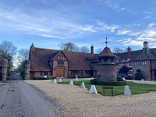
Pednor House is a house near Chartridge parish of Buckinghamshire. It has been listed Grade II on the National Heritage List for England since November 1983.

