
Harrisville is a town in Cheshire County, New Hampshire, United States. Besides the town center, it also includes the villages of Chesham and Eastview. The population of the town was 984 at the 2020 census.

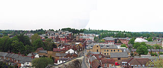
Chesham is a market town and civil parish in Buckinghamshire, England, United Kingdom, 11 miles (18 km) south-east of the county town of Aylesbury, about 26 miles (42 km) north-west of central London, and part of the London commuter belt. It is in the Chess Valley, surrounded by farmland. The earliest records of Chesham as a settlement are from the second half of the 10th century, although there is archaeological evidence of people in this area from around 8000 BC. Henry III granted a royal charter for a weekly market in 1257.

Chivery is a hamlet located in the Chiltern Hills in the present-day parish of Aston Clinton, in Aylesbury Vale District in the county of Buckinghamshire, England. Chivery's southern boundary is formed by the ancient earthworks known as Grim's Ditch. To the north it is bounded by Wendover Woods.
Rickmansworth is a town in south-west Hertfordshire, England, located approximately 17 miles (27 km) north-west of central London, 5 miles (8 km) south-west of Watford and inside the perimeter of the M25 motorway. The town is mainly to the north of the Grand Union Canal and the River Colne.

Hundridge is a hamlet in the parish of Chartridge, in Buckinghamshire, England. It is located in the Chiltern Hills to the west of the town of Chesham. During the 14th century it was known as Hunderugge, and Hundrige in the 15th/16th century. The hamlet name derives from either the Anglo Saxon hunda-hrycg meaning 'hounds' ridge', or from Hundan-hrycg meaning 'Hunda's ridge'.

Pednor is a hamlet in the parish of Chartridge, in Buckinghamshire, England. It is located in the Chiltern Hills two miles northwest of Chesham and seven miles southeast of Wendover.
Chiltern District was a local government district of Buckinghamshire in south-central England from 1974 to 2020. It was named after the Chiltern Hills on which the region sits.

Amersham Rural District was a rural district in the administrative county of Buckinghamshire, England from 1894 to 1974, covering an area in the south-east of the county.

The River Chess is a chalk stream that rises near Chesham in the Chiltern Hills, and flows for 11 miles (18 km) through Buckinghamshire and Hertfordshire to its confluence with the River Colne in Rickmansworth. The Chess, along with the Colne and Gade, gives rise to the name of the district of Three Rivers.

Chesham and Amersham is a parliamentary constituency in Buckinghamshire, South East England, represented in the House of Commons by Sarah Green, a Liberal Democrat elected at a 2021 by-election.

The City and Liberty of Westminster was a unit of local government in the county of Middlesex, England. It was located immediately to the west of the City of London. Originally under the control of Westminster Abbey, the local authority for the area was the Westminster Court of Burgesses from 1585 to 1900. The area now forms the southern part of the City of Westminster in Greater London.

Three river islands (aits) form a linear group, close to the junction of the two main old streets of Thames Ditton village, in the River Thames in a corner of modern Surrey, on the Kingston reach above Teddington Lock. Thames Ditton Island, the dominant ait, is 350 yards (320 m) long and has 48 houses with gardens ; Boyle Farm Island has one house; Swan Island, between the two, is the smallest.

Lye Green is a hamlet in the civil parish of Chesham in Buckinghamshire, England. It is located north east of Chesham. Lycrome Road runs through the centre of the hamlet, from the A416 in the east to the B4505 in the west.
Orchard Leigh is a hamlet in the parish of Latimer in Buckinghamshire, England, located along the B4505 about 2 miles east of Chesham. It is in the civil parish of Ashley Green.
Tylers Hill is a hamlet in the civil parish of Latimer and Ley Hill, in the Buckinghamshire district, in the ceremonial county of Buckinghamshire, England. It is located to the east of Chesham, near Botley. The name is derived from the historic tile making industry in the region. In 1888, a bricklayer's son named Elbourn discovered a buried earthenware vessel filled with gold coins. Although many were dispersed among local children and bystanders, some were eventually taken by the police for the Treasury. The coins were dated to the reigns of Elizabeth I, James I, and Charles I, suggesting they had been buried around the time of the English Civil War.
Winterbrook is a small settlement in the English county of Oxfordshire, which adjoins the south end of Wallingford and sits on the west bank of the Thames. It is separated from Wallingford by Bradford's Brook. In 1974 it was transferred from Berkshire. Although having been part of the adjacent parish of Cholsey for centuries, its proximity to Wallingford resulted in its being absorbed into that town for administrative purposes in 2015. This change was effected despite the strenuous and long-term objections of the residents. It is now part of the Wallingford ward of South Oxfordshire District Council. It remains in the Church of England parish of St Mary the Virgin, North Stoke.

Nolton and Roch is a community in the Hundred of Roose, Pembrokeshire, Wales. The community consists essentially of the villages of Nolton and Roch and a number of hamlets including Cuffern and Druidston. The western part of the community is in the Pembrokeshire Coast National Park. Its population (2001) was 746, increasing to 825 at the 2011 census.

The town of Chesham formed a local government district in the administrative county of Buckinghamshire, England from 1884 to 1974. It was administered as a local government district from 1884 to 1894, and as an urban district from 1894 to 1974.

Chesham Museum is based in Chesham, Buckinghamshire, England. The museum, which is run by volunteers, first opened in 2004 housed in temporary premises known as 'The Stables'. The museum relocated to the town's Market Square, in October 2009. Having been closed for a number of years Chesham Museum is reopening its doors in Chesham Town Hall, January 2024. The museum's collection of artefacts and photographs documents the history of the town and surrounding areas.

St. Mary's Church is a Grade I listed Anglican church in Chesham, Buckinghamshire, and is part of the Diocese of Oxford. Built on the site of a Bronze Age stone circle of puddingstones, parts of the church building date to the 12th century. Remodelled in the 15th and 17th centuries, the church is architecturally a mixture of English Gothic styles. Weakened by additions to the church tower and undermined by burials in and around the church, by the 19th century the building was structurally unsound. The church was remodelled and strengthened in the 1860s by George Gilbert Scott and again in the 20th century by Robert Potter.

