
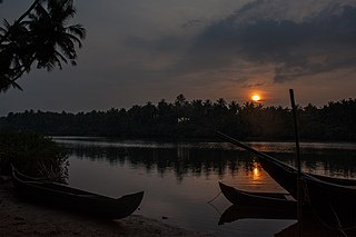
Swamimalai is a panchayat town that is a suburb near Kumbakonam in Thanjavur District in the Indian state of Tamil Nadu. It lies on the banks of river Kaveri and is one of the six abodes of the Lord Muruga.

Darasuram or Dharasuram is a panchayat town located 3 kilometres from Kumbakonam in Thanjavur District, Tamil Nadu, India. According to the 2001 census, the town had a population of 13,027. The town is known for the Airavateswara temple constructed by the Rajaraja Chola II in the 12th century AD. The temple is a recognised UNESCO World Heritage monument.

Tiruchirappalli District is located along the Kaveri River in Tamil Nadu, India. The main town in Tiruchirappalli District is the city of Tiruchirappalli, also known as Trichy. During the British Raj, Tiruchirappalli was known as Trichinopoly, and was a district of the Madras Presidency; it was renamed upon India's declaration of independence in 1947. As of 2011, the district had a population of 2,722,290 with 1,013 females for every 1,000 males.
Devadanapatti is a panchayat town in Periyakulam Taluk, Theni district in the Madurai Region, state of Tamil Nadu, India.This village is located at the foothills of Kodaikanal Hills. Moongilinai Kamatchi Amman temple is one of the famous temple situated here.
Pannaipuram is a panchayat town in Theni district in the Indian state of Tamil Nadu. It is located hill foot of "Western Ghats" sharing its border with Kerala State and has very good literacy. Pannaipuram Town panchayat includes 4 villages namely Pannaipuram, Kariyanampatty, Mallingapuram and P. Renganathapuram. Mahalingeswarar Temple, Kaliamman Temple and Bommaiyaswamy Temple are located in Pannaipuram. Veereswarar Temple is located in Kariyanampatty. Most of the people in Pannaipuram are engaged in Cardamom cultivation and trade in nearby Kerala hills.

Pattukkottai in Thanjavur district in the Indian state of Tamil Nadu. The town came to prominence throughout Southern India after the construction of the fort by Vanaji Pandithar, a feudatory of the Thanjavur Maratha ruler Shahuji I in 1686–87. The recorded history of Pattukkottai is known from the 17th century and has been ruled, at different times, by the Thanjavur Marathas and the British. It is the headquarters of the Pattukkottai taluk of Thanjavur district and is one of the two municipalities in the district.
Peravurani is a panchayat town in Thanjavur district in the Indian state of Tamil Nadu. It is the administrative headquarters of the Peravurani Taluk and Peravurani. It is declared as Selection Grade Town Panchayat.
Sethiathope is a panchayat town in Bhuvanagiri Taluk, Cuddalore district in the Indian state of Tamil Nadu. It is situated on the crossroads of Chennai - Tanjore (NH-45C) Highway. Sethiyathope was established as a civilian town by the Cholas in the 11th century C.E. According to Tamil scholars, Sethiyathope was formed as a settlement when the famous Chola King Rajendra moved his capital from Thanjavur to Gangaikondacholapuram which lies 20 km south.

Surada is a town and a Notified Area Council in Ganjam district in the Indian state of Odisha. Surada is also the headquarter of Surada Block of which area is about 2663.89 km2. Surada Block consists of 25 Gram Panchayats with 364 villages and Surada (N.A.C.) as an urban administration. It is located on the bank of Rushikulya.
Thirukattupalli is a panchayat town near Thiruvaiyaru in Thanjavur district in the Indian state of Tamil Nadu. The economy of this town is majorly based on the agricultural lands of the surrounding villages. Its nearby major cities include Thanjavur and Trichy. Modes of transportation to these cities include regular daily bus services and Budalur Railway Station. Sir P. S. Sivaswami Iyer Higher Secondary School located at the heart of this town serves as the alma-mater for nearly all locals.

Thuraiyur is a town and a municipality in the Tiruchirappalli district in the Indian state of Tamil Nadu. It was upgraded to a III Grade Municipality from Town Panchayat on 17 January 1970, and to a II Grade Municipality in May 1998. It was upgraded to Selection Grade Municipality in the year 2008. It is also a taluka. Thuraiyur(Sub district)is the main town of Tiruchirappalli district. Thuraiyur town is expected to become Thuraiyur district with the addition of a new railway track. Thuraiyur is at the center of Tamil Nadu, connected to many main cities. It is located 310 km away from Chennai.In Trichy district biggest municipality is Thuraiyur and nowadays here 1lakh peoples are living but here water issues, ward rearrangement, city development plans not yet done by Thuraiyur Municipality Corporation.
Uthukottai is a border town and panchayat town in Tamil Nadu, next to Andhra Pradesh, located on the banks of the Arani river. The town features a channel which helps to direct water from the Krishna river for local irrigation.
Kattimedu is a small village situated in Tiruvarur district of Tamil Nadu, India. It belongs to Kattimedu and Adirangam Panchayat.
Vallikkunnu is a village in Malappuram district in the state of Kerala, India with an area of 25 km2. Its latitude and longitude are 11'07" N and 7'51"E respectively. Vallikkunnu was awarded the best panchayath of Kerala in 1997.
Thennamanadu is a village panchayat in Orattanadu Block of Thanjavur district in Tamil Nadu, South India. It is located between the cities of Thanjavur and Pattukkottai, 20 km (12 mi) from Thanjavur, 2 km (1.2 mi) from Orathanadu and 339 km from state capital Chennai.
Thittakkudi is a village located near Pattukkottai town in Thanjavur district in the state of Tamil Nadu, India. The village is located at about 6 km north of Pattukkottai on Pattukkottai - Kumbakonam highway & 350 km South from the state capital, Chennai. The village follows the Panchayati raj system, where every 5 years the Panchayat President will be democratically elected by the people. Thittakkudi panchayat consists of two villages Thittakkudi & Soorangadu. Currently the village is undergoing transformation under the panchayat. Efforts have been made for empowerment of women and lower-middle-class people in the village. The main purpose of the village President is to give very good basic facilities for all the people.
Rajagiri is a panchayat village in the Papanasam taluk of Thanjavur district, Tamil Nadu, India.
Vattakudi Ukkadai, also known as Vattakudi South is a village in Tamil Nadu, India. It is located in the Madukur block of Thanjavur district.

Kalathur is a panchayat village in Peravurani panchayat Union of Thanjavur district in the Indian state of Tamil Nadu. Kalathur is a part of the Pattukkottai taluk of Thanjavur district and located 67 kilometres (42 mi) south of Thanjavur connected via State Highway 29.
Adambai is a village situated 9 km away from sub-district headquarter Pattukkottai and 60 km away from district headquarter Thanjavur. It is one of the biggest panchayat under Tiruvonam union. Adambai is under Peravurani constituency.
