Pervomaysky District, Nizhny Novgorod Oblast

Last updated

Coordinates: 54°52′N43°48′E / 54.867°N 43.800°E / 54.867; 43.800

Geographic coordinate system Coordinate system

A geographic coordinate system is a coordinate system that enables every location on Earth to be specified by a set of numbers, letters or symbols. The coordinates are often chosen such that one of the numbers represents a vertical position and two or three of the numbers represent a horizontal position; alternatively, a geographic position may be expressed in a combined three-dimensional Cartesian vector. A common choice of coordinates is latitude, longitude and elevation. To specify a location on a plane requires a map projection.

Contents

Location of Pervomaysky District in Nizhny Novgorod Oblast Pervomaysky District on map of Nizhny Novgorod Region.svg
Location of Pervomaysky District in Nizhny Novgorod Oblast

Pervomaysky District (Russian : Первома́йский райо́н) was an administrative [1] and municipal [2] district (raion) in Nizhny Novgorod Oblast, Russia. It was located in the south of the oblast. The area of the district was 1,227.3 square kilometers (473.9 sq mi). [1] Its administrative center was the town of Pervomaysk. [1] Population: 20,455 (2010 Census); [3] 22,344(2002 Census); [4] 26,926(1989 Census). [5] The population of Pervomaysk accounted for 71.2% of the district's total population. [3]

Russian language East Slavic language

Russian is an East Slavic language, which is official in the Russian Federation, Belarus, Kazakhstan and Kyrgyzstan, as well as being widely used throughout Eastern Europe, the Baltic states, the Caucasus and Central Asia. It was the de facto language of the Soviet Union until its dissolution on 25 December 1991. Although nearly three decades have passed since the breakup of the Soviet Union, Russian is used in official capacity or in public life in all the post-Soviet nation-states, as well as in Israel and Mongolia.

A raion is a type of administrative unit of several post-Soviet states. The term is from the French "rayon", which is both a type of a subnational entity and a division of a city, and is commonly translated in English as "district".

Nizhny Novgorod Oblast First-level administrative division of Russia

Nizhny Novgorod Oblast, also known as Nizhegorod Oblast, is a federal subject of Russia. Its administrative center is the city of Nizhny Novgorod. It has a population of 3,310,597 as of the 2010 Census. From 1932 to 1990 it was known as Gorky Oblast.

History

The district was established in 1929. [1] Per Law #83-Z of July 3, 2012, the district was transformed into a town of oblast significance of Pervomaysk. In the similar manner, Law #82-Z abolished Pervomaysky Municipal District and transformed it into Pervomaysk Urban Okrug.

City of federal subject significance is an umbrella term used to refer to a type of an administrative division of a federal subject of Russia which is equal in status to a district but is organized around a large city; occasionally with surrounding rural territories.

Pervomaysk, Nizhny Novgorod Oblast Town in Nizhny Novgorod Oblast, Russia

Pervomaysk is a town in Nizhny Novgorod Oblast, Russia, located 190 kilometers (120 mi) south of Nizhny Novgorod. Population: 14,568 (2010 Census); 15,094 (2002 Census); 16,428 (1989 Census); 16,000 (1974).

Administrative and municipal divisions

As of July 2012, the district was administratively divided into one town of district significance (Pervomaysk), one work settlement (Satis), and two selsoviets (comprising forty-three rural localities). [1] Municipally, Pervomaysky Municipal District was divided into two urban settlements and two rural settlements. [2]

Town of district significance is an administrative division of a district in a federal subject of Russia. It is equal in status to a selsoviet or an urban-type settlement of district significance, but is organized around a town ; often with surrounding rural territories.

Urban-type settlement is an official designation for a semi-urban settlement, used in several Eastern European countries. The term was historically used in Bulgaria, Poland, and the Soviet Union, and remains in use today in 10 of the post-Soviet states.

Selsoviet is a shortened name for a rural council and for the area governed by such a council (soviet). The full names for the term are, in Belarusian: се́льскi Саве́т, Russian: се́льский Сове́т, Ukrainian: сільська́ ра́да. Selsoviets were the lowest level of administrative division in rural areas in the Soviet Union. After the dissolution of the Soviet Union, they were preserved as a third tier of administrative-territorial division throughout Ukraine, Belarus, and some of the federal subjects of Russia.

Related Research Articles

Lyskovsky District District in Nizhny Novgorod Oblast, Russia

Lyskovsky District is an administrative district (raion), one of the forty in Nizhny Novgorod Oblast, Russia. Municipally, it is incorporated as Lyskovsky Municipal District. It is located in the east of the oblast on both sides of the Volga River. The area of the district is 2,134 square kilometers (824 sq mi). Its administrative center is the town of Lyskovo. Population: 39,964 ; 43,755 (2002 Census); 46,895 (1989 Census). The population of Lyskovo accounts for 54.7% of the district's total population.

Arzamassky District District in Nizhny Novgorod Oblast, Russia

Arzamassky District is an administrative district (raion), one of the forty in Nizhny Novgorod Oblast, Russia. Municipally, it is incorporated as Arzamassky Municipal District. It is located in the southern central part of the oblast. The area of the district is 2,016.9 square kilometers (778.7 sq mi). Its administrative center is the city of Arzamas. Population: 43,723 ; 46,086 (2002 Census); 54,491 (1989 Census).

Bogorodsky District, Nizhny Novgorod Oblast District in Nizhny Novgorod Oblast, Russia

Bogorodsky District is an administrative district (raion), one of the forty in Nizhny Novgorod Oblast, Russia. Municipally, it is incorporated as Bogorodsky Municipal District. It is located in the west of the oblast. The area of the district is 1,459 square kilometers (563 sq mi). Its administrative center is the town of Bogorodsk. Population: 65,677 ; 30,864 (2002 Census); 33,693 (1989 Census). The population of Bogorodsk accounts for 54.1% of the district's total population.

Bolsheboldinsky District District in Nizhny Novgorod Oblast, Russia

Bolsheboldinsky District is an administrative district (raion), one of the forty in Nizhny Novgorod Oblast, Russia. Municipally, it is incorporated as Bolsheboldinsky Municipal District. It is located in the southeast of the oblast. The area of the district is 866.5 square kilometers (334.6 sq mi). Its administrative center is the rural locality of Bolshoye Boldino. Population: 12,035 ; 13,035 (2002 Census); 14,156 (1989 Census). The population of Bolshoye Boldino accounts for 42.2% of the district's total population.

Diveyevsky District District in Nizhny Novgorod Oblast, Russia

Diveyevsky District is an administrative district (raion), one of the forty in Nizhny Novgorod Oblast, Russia. Municipally, it is incorporated as Diveyevsky Municipal District. It is located in the south of the oblast. The area of the district is 844.8 square kilometers (326.2 sq mi). Its administrative center is the rural locality of Diveyevo. Population: 16,618 ; 17,848 (2002 Census); 18,375 (1989 Census). The population of Diveyevo accounts for 38.6% of the district's total population.

Gaginsky District District in Nizhny Novgorod Oblast, Russia

Gaginsky District is an administrative district (raion), one of the forty in Nizhny Novgorod Oblast, Russia. Municipally, it is incorporated as Gaginsky Municipal District. It is located in the southeast of the oblast. The area of the district is 1,064.2 square kilometers (410.9 sq mi). Its administrative center is the rural locality of Gagino. Population: 12,444 ; 15,079 (2002 Census); 17,473 (1989 Census). The population of Gagino accounts for 31.3% of the district's total population.

Knyagininsky District District in Nizhny Novgorod Oblast, Russia

Knyagininsky District is an administrative district (raion), one of the forty in Nizhny Novgorod Oblast, Russia. Municipally, it is incorporated as Knyagininsky Municipal District. It is located in the east of the oblast. The area of the district is 769.9 square kilometers (297.3 sq mi). Its administrative center is the town of Knyaginino. Population: 11,922 ; 12,758 (2002 Census); 12,827 (1989 Census). The population of Knyaginino accounts for 56.3% of the district's total population.

Perevozsky District District in Nizhny Novgorod Oblast, Russia

Perevozsky District is an administrative district (raion), one of the forty in Nizhny Novgorod Oblast, Russia. Municipally, it is incorporated as Perevozsky Municipal District. It is located in the southern central part of the oblast. The area of the district is 769.2 square kilometers (297.0 sq mi). Its administrative center is the town of Perevoz. Population: 16,519 ; 18,024 (2002 Census); 17,146 (1989 Census). The population of Perevoz accounts for 55.7% of the district's total population.

Sechenovsky District District in Nizhny Novgorod Oblast, Russia

Sechenovsky District is an administrative district (raion), one of the forty in Nizhny Novgorod Oblast, Russia. Municipally, it is incorporated as Sechenovsky Municipal District. It is located in the southeast of the oblast. The area of the district is 991 square kilometers (383 sq mi). Its administrative center is the rural locality of Sechenovo. Population: 15,446 ; 17,741 (2002 Census); 19,338 (1989 Census). The population of Sechenovo accounts for 34.1% of the district's total population.

Sergachsky District District in Nizhny Novgorod Oblast, Russia

Sergachsky District is an administrative district (raion), one of the forty in Nizhny Novgorod Oblast, Russia. Municipally, it is incorporated as Sergachsky Municipal District. It is located in the southeast of the oblast. The area of the district is 1,243.8 square kilometers (480.2 sq mi). Its administrative center is the town of Sergach. Population: 31,296 ; 35,779 (2002 Census); 42,588 (1989 Census). The population of Sergach accounts for 68.3% of the district's total population.

Spassky District, Nizhny Novgorod Oblast District in Nizhny Novgorod Oblast, Russia

Spassky District is an administrative district (raion), one of the forty in Nizhny Novgorod Oblast, Russia. Municipally, it is incorporated as Spassky Municipal District. It is located in the east of the oblast. The area of the district is 706.6 square kilometers (272.8 sq mi). Its administrative center is the rural locality of Spasskoye. Population: 10,998 ; 13,533 (2002 Census); 16,204 (1989 Census). The population of Spasskoye accounts for 35.9% of the district's total population.

Vadsky District District in Nizhny Novgorod Oblast, Russia

Vadsky District is an administrative district (raion), one of the forty in Nizhny Novgorod Oblast, Russia. Municipally, it is incorporated as Vadsky Municipal District. It is located in the southern central part of the oblast. The area of the district is 742.7 square kilometers (286.8 sq mi). Its administrative center is the rural locality of Vad. Population: 15,626 ; 16,442 (2002 Census); 15,365 (1989 Census). The population of Vad accounts for 42.9% of the district's total population.

Volodarsky District, Nizhny Novgorod Oblast District in Nizhny Novgorod Oblast, Russia

Volodarsky District is an administrative district (raion), one of the forty in Nizhny Novgorod Oblast, Russia. Municipally, it is incorporated as Volodarsky Municipal District. It is located in the west of the oblast. The area of the district is 1,045.6 square kilometers (403.7 sq mi). Its administrative center is the town of Volodarsk. Population: 58,807 ; 59,498 (2002 Census). The population of Volodarsk accounts for 16.9% of the district's total population.

Bolshoye Boldino Rural locality in Nizhny Novgorod Oblast, Russia

Bolshoye Boldino is a rural locality and the administrative center of Bolsheboldinsky District, Nizhny Novgorod Oblast, Russia. Population: 5,074 (2010 Census); 4,919 (2002 Census); 4,432 (1989 Census).

Vad is a rural locality and the administrative center of Vadsky District, Nizhny Novgorod Oblast, Russia. Population: 6,698 (2010 Census); 6,759 (2002 Census); 6,058 (1989 Census).

Gagino is a rural locality and the administrative center of Gaginsky District, Nizhny Novgorod Oblast, Russia. Population: 3,891 (2010 Census); 4,001 (2002 Census); 3,865 (1989 Census).

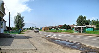
Urazovka is a rural locality and the administrative center of Krasnooktyabrsky District, Nizhny Novgorod Oblast, Russia. Population: 1,626 (2010 Census); 1,916 (2002 Census); 2,303 (1989 Census).

Sechenovo is a rural locality and the administrative center of Sechenovsky District, Nizhny Novgorod Oblast, Russia. Population: 5,263 (2010 Census); 5,239 (2002 Census); 4,085 (1989 Census).

Spasskoye is a rural locality and the administrative center of Spassky District, Nizhny Novgorod Oblast, Russia. Population: 3,947 (2010 Census); 4,092 (2002 Census); 4,044 (1989 Census).

References

Notes

  1. 1 2 3 4 5 Order #1-od; revision prior to July 3, 2012
  2. 1 2 Resolution #670; revision prior to July 3, 2012
  3. 1 2 Russian Federal State Statistics Service (2011). "Всероссийская перепись населения 2010 года. Том 1" [2010 All-Russian Population Census, vol. 1]. Всероссийская перепись населения 2010 года (2010 All-Russia Population Census) (in Russian). Federal State Statistics Service . Retrieved June 29, 2012.
  4. Russian Federal State Statistics Service (May 21, 2004). "Численность населения России, субъектов Российской Федерации в составе федеральных округов, районов, городских поселений, сельских населённых пунктов – районных центров и сельских населённых пунктов с населением 3 тысячи и более человек" [Population of Russia, Its Federal Districts, Federal Subjects, Districts, Urban Localities, Rural Localities—Administrative Centers, and Rural Localities with Population of Over 3,000](XLS). Всероссийская перепись населения 2002 года [All-Russia Population Census of 2002] (in Russian). Retrieved August 9, 2014.
  5. Demoscope Weekly (1989). "Всесоюзная перепись населения 1989 г. Численность наличного населения союзных и автономных республик, автономных областей и округов, краёв, областей, районов, городских поселений и сёл-райцентров" [All Union Population Census of 1989: Present Population of Union and Autonomous Republics, Autonomous Oblasts and Okrugs, Krais, Oblasts, Districts, Urban Settlements, and Villages Serving as District Administrative Centers]. Всесоюзная перепись населения 1989 года [All-Union Population Census of 1989] (in Russian). Институт демографии Национального исследовательского университета: Высшая школа экономики [Institute of Demography at the National Research University: Higher School of Economics]. Retrieved August 9, 2014.

Sources