
The blue petrel is a small seabird in the shearwater and petrel family, Procellariidae. This small petrel is the only member of the genus Halobaena, but is closely allied to the prions. It is distributed across the Southern Ocean but breeds at a few island sites, all close to the Antarctic Convergence zone.
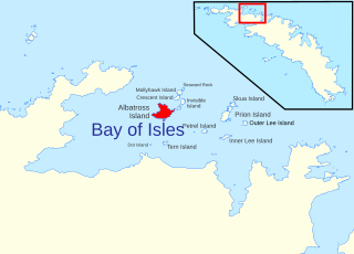
Albatross Island is an island 2 miles (3 km) southeast of Cape Buller, lying in the Bay of Isles, South Georgia. Charted in 1912–13 by Robert Cushman Murphy, American naturalist aboard the brig Daisy, who gave this name because he observed albatrosses there. The eastern headland of the island is called The Pricker, a name which first appeared on a 1931 British Admiralty chart.

The Antarctic prion also known as the dove prion, or totorore in Māori, is the largest of the prions, a genus of small petrels of the Southern Ocean.
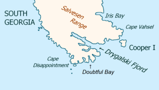
Cooper Island is a small island, 2 miles (3.2 km) long, which lies at the north side of the entrance to Drygalski Fjord, off the southeast end of South Georgia. It was discovered by a British expedition under James Cook in 1775, and named for Lieutenant Robert Palliser Cooper, an officer aboard HMS Resolution.

Schlieper Bay is a bay 1 mile (1.6 km) wide, entered between Romerof Head and Weddell Point along the south coast of South Georgia. It is separated from Church Bay by the Scree Gap. Schlieper Bay was named between 1905 and 1912 after the director of the Compañía Argentina de Pesca.
You may be looking for Undine South Harbour near Ducloz Head, South Georgia
Prion Island is an island 2.4 km (1.5 mi) north-northeast of Luck Point, lying in the Bay of Isles, South Georgia. It was charted in 1912-13 by Robert Cushman Murphy, American naturalist aboard the brig Daisy, and so named because he observed prions on the island.
Mollyhawk Island is a small, tussock-covered island lying between Seaward Rock and Crescent Island in the northern part of the Bay of Isles, South Georgia. It was charted in 1912–13 by Robert Cushman Murphy, an American naturalist aboard the brig Daisy. The island was surveyed in 1929–30 by Discovery Investigations personnel and named in association with Albatross Island, Prion Island and other natural history names in the Bay of Isles given by Murphy, "mollyhawk" being a name for a type of young gull.

The Bay of Isles is a bay 9 miles (14 km) wide and receding 3 miles (5 km), lying between Cape Buller and Cape Wilson along the north coast of South Georgia. It was discovered in 1775 by a British expedition under James Cook and so named by him because numerous islands lie in the bay. Of South Georgia's 31 breeding bird species, 17 are found here.
Skua Island is an island immediately northeast of Prion Island in the entrance to the Bay of Isles, South Georgia. Charted in 1912-13 by Robert Cushman Murphy, American naturalist aboard the brig Daisy. Surveyed in 1929-30 by DI personnel and named in association with Albatross Island, Prion Island and other natural history names given in the Bay of Isles by Murphy in 1912–13.
Tern Island in the south part of the Bay of Isles, South Georgia is a small, tussock-covered island lying 1.6 km south of Albatross Island and 10 km east of Dot Island.

Larsen Harbour is a narrow 2.6 miles (4.2 km) long inlet of indenting volcanic rocks and sheeted dykes known as the Larsen Harbour Formation. It is a branch of Drygalski Fjord, entered 2.5 miles (4 km) west-northwest of Nattriss Head, at the southeast end of South Georgia Island. It was charted by the Second German Antarctic Expedition, 1911–12, under Filchner, who named it for Captain Carl Anton Larsen a Norwegian explorer, who made significant contributions to the exploration of Antarctica. The most significant of these was the first discovery of fossils on the continent, for which he received the Back Grant from the Royal Geographical Society. Larsen is also considered the founder of the Antarctic whaling industry and the settlement and whaling station of Grytviken, South Georgia.
The Southern Indian Ocean Islands tundra is a tundra ecoregion that includes several subantarctic islands in the southern Indian Ocean.
Inner Lee Island is a small island 1.3 km (0.8 mi) north-northeast of Luck Point, lying in the Bay of Isles, South Georgia. This island was charted in 1912–13 by Robert Cushman Murphy, an American naturalist abroad the brig Daisy, who included it as one of two islands which called the "Lee Islands". These islands were recharted in 1929–30 by Discovery Investigations personnel, who renamed this southwestern of the two, Inner Lee Island. The northeastern island is now known as Outer Lee Island.

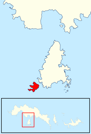
Saddle Island is 1.98 kilometres long and 980 metres wide, situated on the south side of the entrance to Wilson Harbour on the west coast of South Georgia Island in the Antarctic. The island is separated from the mainland of South Georgia by a 280 metres wide passage.
Outer Lee Island is a small island 1.5 nautical miles (2.8 km) north-northwest of Bellingshausen Point, lying in the outer part of the Bay of Isles, South Georgia. This island was charted in 1912-13 by Robert Cushman Murphy, American naturalist aboard the brig Daisy, who included it as one of two islands which he called the Lee Islands. These islands were recharted in 1929-30 by DI personnel, who renamed this northeastern of the two, Outer Lee Island. The southwestern island is now known as Inner Lee Island.
Coal Island is a small tussock-covered island with off-lying rocks marking the west side of the entrance to Coal Harbor, near the west end of South Georgia. It was charted by Discovery Investigations personnel on the Discovery during the period 1926–30, and by HMS Owen in 1960–61. It was named by the UK Antarctic Place-Names Committee in 1963 in association with Coal Harbor.
Moe Island is an island 2 km (1.2 mi) long in the South Orkney Islands off Antarctica, separated from the south-west end of Signy Island by Fyr Channel. It was charted by Captain Petter Sørlle in 1912–13, and named after M. Thoralf Moe of Sandefjord, Norway, a contemporary whaling captain who worked in this area. The northernmost point of the island is Spaull Point, named by United Kingdom Antarctic Place-Names Committee (UK-APC) after Vaughan W. Spaull, British Antarctic Survey (BAS) biologist on Signy Island, 1969.