The Sioux or Oceti Sakowin are groups of Native American tribes and First Nations people from the Great Plains of North America. The Sioux have two major linguistic divisions: the Dakota and Lakota peoples. Collectively, they are the Očhéthi Šakówiŋ, or "Seven Council Fires". The term "Sioux", an exonym from a French transcription ("Nadouessioux") of the Ojibwe term "Nadowessi", can refer to any ethnic group within the Great Sioux Nation or to any of the nation's many language dialects.

Dakota County is the third-most populous county in the U.S. state of Minnesota, located in the east central portion of the state. As of the 2020 census, the population was 439,882. The population of Dakota County was estimated to be 447,440 in 2023. The county seat is Hastings. Dakota County is named for the Dakota Sioux tribal bands who inhabited the area.

Mendota is a city in Dakota County, Minnesota, United States. The name is a mispronunciation of the Dakota word for the location, bdóte, which in Dakota tradition is the center of the world. The word in this use means "the confluence of the Minnesota and Mississippi Rivers," and generally "mouth or junction of one river with another." The population was 198 at the 2010 census.

Fort Snelling is a former military fortification and National Historic Landmark in the U.S. state of Minnesota on the bluffs overlooking the confluence of the Minnesota and Mississippi Rivers. The military site was initially named Fort Saint Anthony, but it was renamed Fort Snelling once its construction was completed in 1825.

Henry Hastings Sibley was a fur trader with the American Fur Company, the first U.S. Congressional representative for Minnesota Territory, the first governor of the state of Minnesota, and a U.S. military leader in the Dakota War of 1862 and a subsequent expedition into Dakota Territory in 1863.
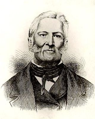
Jean-Baptiste Faribault was a trader with varipus groups of Native Americans and early settler in Minnesota.
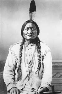
The Mdewakanton or Mdewakantonwan are one of the sub-tribes of the Isanti (Santee) Dakota (Sioux). Their historic home is Mille Lacs Lake in central Minnesota. Together with the Wahpekute, they form the so-called Upper Council of the Dakota or Santee Sioux. Today their descendants are members of federally recognized tribes in Minnesota, South Dakota and Nebraska of the United States, and First Nations in Manitoba, Canada.

Fort Snelling State Park is a state park of the U.S. state of Minnesota, at the confluence of the Mississippi and Minnesota rivers. For many centuries, the area of the modern park has been of importance to the Mdewakanton Dakota people who consider it the center of the Earth. The state park, which opened in 1962, is named for the historic Fort Snelling, which dates from 1820. The fort structure is maintained and operated by the Minnesota Historical Society. The bulk of the state park preserves the bottomland forest, rivers, and backwater lakes below the river bluffs. Both the state and historic fort structure are part of the Mississippi National River and Recreation Area, a National Park Service site.

Kaposia or Kapozha was a seasonal and migratory Dakota settlement, also known as "Little Crow's village," once located on the east side of the Mississippi River in present-day Saint Paul, Minnesota. The Kaposia band of Mdewakanton Dakota was established in the late 18th century and led by a succession of chiefs known as Little Crow or "Petit Corbeau." After a flood in 1826, the band moved to the west side of the river, about nine miles below Fort Snelling.

Coldwater Spring is a spring in the Fort Snelling unorganized territory of the U.S. state of Minnesota, that is considered a sacred site by the Dakota people, and was also the site of the U.S. Army's Camp Coldwater for troops that constructed Fort Snelling. Coldwater Spring is located on the west bluffs of the Mississippi River directly south of Minnehaha Park and adjacent to Fort Snelling State Park. Waters from the naturally occurring spring flow continuously year round and remain unfrozen in winter months. The spring and surrounding area is managed as a protected historic site and natural park by the National Park Service as part of the Mississippi National River and Recreation Area.
The Dakota are a Native American tribe and First Nations band government in North America. They compose two of the three main subcultures of the Sioux people, and are typically divided into the Eastern Dakota and the Western Dakota.

Tamaha, also known as Standing Moose or "L'Orignal Levé," was one of two Mdewakanton Dakota scouts for the United States in the War of 1812, when most Sioux sided with the British. He was a member of Chief Red Wing's band and was presented with a medal and certificate by Governor William Clark of Missouri Territory for his loyalty to the U.S. The certificate was treasured by Tamaha, who called himself "the 'only' American Sioux," and can now be seen at the Minnesota History Center.

Shepard Road and Warner Road are the names given to a four-lane road running along the banks of the Mississippi River in Saint Paul, Minnesota. Shepard Road runs from the southwestern boundary of the county to downtown Saint Paul. From downtown east the road is known as Warner Road (County Road 36; it runs to a junction with US Highways 61 and 10.
Shakopee or Chief Shakopee may refer to one of at least three Mdewakanton Dakota leaders who lived in the area that became Minnesota from the late 18th century through 1865. The name comes from the Dakota Śakpe meaning "Six." According to tribal histories, the very first "Shakpe" was called that because he was the sixth child of a set of sextuplets.

Wabasha II, also known as Wapahasha, Wapasha, or "The Leaf," succeeded his father as head chief of the Mdewakanton Dakota tribe in the early 1800s. He led the Dakota forces fighting with the British in the War of 1812, but sided with the United States in the Black Hawk War of 1832. Chief Wabasha II signed the Treaties of Prairie du Chien in 1825 and 1830.
Cloud Man was a Dakota chief. The child of French and Mdewakanton parents, he founded the agricultural community Ḣeyate Otuŋwe on the shores of Bde Maka Ska in 1829 after being trapped in a snowstorm for three days. The village was seen by white settlers as a progressive step towards assimilation, yet members of the community maintained a distinctly Dakota way of life. The community was abandoned in 1839 and Cloud Man's band moved along the Minnesota River to join the Hazelwood Republic.
Red Wing II, also known as Tatankamani was a leader of the Mdewakanton Dakota in the upper Mississippi Valley. During the War of 1812, Chief Red Wing II initially supported the British together with other Dakota chiefs, but switched sides to support the Americans in 1814. His village was at Barn Bluff in present-day Red Wing, Minnesota.

Mendota Mdewakanton Dakota Tribal Community is a Dakota community centered in Mendota, Minnesota. The Mendota Mdewakanton Dakota Tribal Community (MMDTC) is an organization that works to continue Dakota cultural practices and tribal organization. Officially formed in 1997, the MMDTC has sought to be a federally recognized tribe by the US Bureau of Indian Affairs, as well as offering community activities such as pow wows, Dakota language and culture classes, and partnership with the Minnesota Historical Society.

Oheyawahi-Pilot Knob is a scenic overlook, and a Native American gathering place and burial ground in Mendota Heights, Minnesota, United States. The overlook provides views of the confluence of the Minnesota and Mississippi Rivers, Fort Snelling, and the Minneapolis and St. Paul skylines. It was the site of the 1851 Treaty of Mendota between the United States federal government and the Dakota people of Minnesota, who consider the site sacred. In 2017, Oheyawahi-Pilot Knob was listed on the National Register of Historic Places.

Bdóte is a significant Dakota sacred landscape where the Minnesota and Mississippi Rivers meet, encompassing Pike Island, Fort Snelling, Coldwater Spring, Indian Mounds Park, and surrounding areas in present-day Minneapolis and Saint Paul, Minnesota, United States. In Dakota geographic memory, it is a single contiguous area not delineated by any contemporary areas' borders. According to Dakota oral tradition, it is the site of creation; the interconnectedness between the rivers, earth, and sky are important to the Dakota worldview and the site maintains its significance to the Dakota people.


