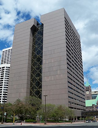
Hennepin County is a county in the U.S. state of Minnesota. Its county seat is Minneapolis, the state's most populous city. The county is named for the 17th-century explorer Louis Hennepin. It extends from Minneapolis to the suburbs and outlying cities in the western part of the county. Its natural areas are covered by extensive woods, hills, and lakes. As of the 2020 census, the population was 1,281,565. It is Minnesota's most populous county and the 34th-most populous county in the U.S.; more than one in five Minnesotans live in Hennepin County. It is included in the Minneapolis–Saint Paul–Bloomington Metropolitan Statistical Area.

Minnetonka is a city in Hennepin County, Minnesota, United States. A western suburb of the Twin Cities, Minnetonka is located about 10 miles (16 km) west of Minneapolis. At the 2020 census, the city's population was 53,781.

Saint Anthony Falls, or the Falls of Saint Anthony, located at the northeastern edge of downtown Minneapolis, Minnesota, was the only natural major waterfall on the Mississippi River. Throughout the mid-to-late 1800s, various dams were built atop the east and west faces of the falls to support the milling industry that spurred the growth of the city of Minneapolis. In 1880, the central face of the falls was reinforced with a sloping timber apron to stop the upstream erosion of the falls. In the 1950s, the apron was rebuilt with concrete, which makes up the most visible portion of the falls today. A series of locks were constructed in the 1950s and 1960s to extend navigation to points upstream.

The North Loop is a neighborhood in the Central community of Minneapolis.

Minnehaha Park is a city park in Minneapolis, Minnesota, United States, and home to Minnehaha Falls and the lower reaches of Minnehaha Creek. Officially named Minnehaha Regional Park, it is part of the Minneapolis Park and Recreation Board system and lies within the Mississippi National River and Recreation Area, a unit of the National Park Service. The park was designed by landscape architect Horace W.S. Cleveland in 1883 as part of the Grand Rounds Scenic Byway system, and was part of the popular steamboat Upper Mississippi River "Fashionable Tour" in the 1800s.

Minneapolis is officially defined by its city council as divided into 83 neighborhoods. The neighborhoods are historically grouped into 11 communities. Informally, there are city areas with colloquial labels. Residents may also group themselves by their city street suffixes: North, Northeast, South, and Southeast.

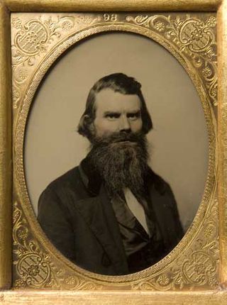
John Harrington Stevens was the first authorized colonial resident on the west bank of the Mississippi River in what would become Minneapolis, Minnesota. He was granted permission to occupy the site, then part of the Fort Snelling military reservation, in exchange for providing ferry service to St. Anthony across the river. The Stevens House was moved several times, finally to Minnehaha Park in south Minneapolis in 1896. The house is now a museum, with tours available on summer weekends. The home was considered to be a civic and social hub of the city, and was used to organize both Hennepin County and the city of Minneapolis.

The Midtown Greenway is a 5.7-mile (9.2 km) rail trail in Minneapolis, Minnesota that follows the path of an abandoned route of the Milwaukee Road railway. It is considered under segregated cycle facilities.

This is a list of sites in Minnesota which are included in the National Register of Historic Places. There are more than 1,700 properties and historic districts listed on the NRHP; each of Minnesota's 87 counties has at least 2 listings. Twenty-two sites are also National Historic Landmarks.

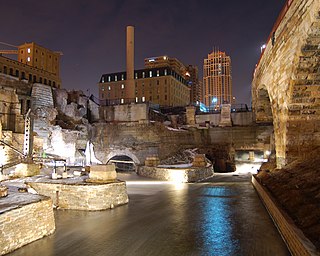
Mill Ruins Park is a park in downtown Minneapolis, Minnesota, United States, standing on the west side of Saint Anthony Falls on the Mississippi River and running from 3rd Ave. S. to about 9th Ave. S. The park interprets the history of flour milling in Minneapolis and shows the ruins of several flour mills that were abandoned.

The following are all the contributing resources to the Saint Anthony Falls Historic District in Minneapolis, Minnesota, United States. The District is listed on the National Register of Historic Places, thus these properties are on the NRHP. The "period of significance" of the District was 1858–1941. The district's archaeological record is considered to be one of the most-endangered historic sites in Minnesota.

King Field is a neighborhood in the Southwest community in Minneapolis, Minnesota. Its boundaries are 36th Street to the north, Interstate 35W to the east, 46th Street to the south, and Lyndale Avenue to the west. King Field, within the King Field neighborhood is a park named after Martin Luther King Jr.

The Charles H. Burwell House is a historic house museum in Minnetonka, Minnesota, United States, built in 1883. Charles H. Burwell (1838–1917) was the secretary and manager of the Minnetonka Mills Company, the first mill west of Minneapolis, around which grew the first permanent Euro-American settlement in Hennepin County west of Minneapolis. This property on Minnehaha Creek, including the house and two outbuildings, is listed on the National Register of Historic Places for its Carpenter Gothic/Stick style architecture and association with Minnetonka's early milling history.

This list is of the properties and historic districts which are designated on the National Register of Historic Places or that were formerly so designated, in Hennepin County, Minnesota; there are 194 entries as of November 2024. A significant number of these properties are a result of the establishment of Fort Snelling, the development of water power at Saint Anthony Falls, and the thriving city of Minneapolis that developed around the falls. Many historic sites outside the Minneapolis city limits are associated with pioneers who established missions, farms, and schools in areas that are now suburbs in that metropolitan area.

The Longfellow House in Minneapolis, Minnesota, United States, is a 2/3-scale replica of Henry Wadsworth Longfellow's home in Cambridge, Massachusetts. Built in 1907, the house was neither seen nor lived in by Longfellow, but was the home of an admiring Minneapolis businessman named Robert "Fish" Jones. Longfellow House stands within Minnehaha Park and is a contributing property to the Minnehaha Historic District.

The Bardwell–Ferrant House is a house in the Phillips West neighborhood of Minneapolis, Minnesota, United States. It was built in 1883 at 1800 Park Avenue for its first owner, Charles Bardwell, and its original plan was in the Queen Anne style. In 1890 its second owner, Emil Ferrant, had the house remodeled in the Moorish Revival style that was popular at the time. Norwegian-born architect Carl F. Struck added two onion domed towers, a wraparound porch with spindlework columns, ogee arches, and deep-toned stained glass windows. The house was later moved to its present location at 2500 Portland Ave. S. in 1898 to make way for a bank building.

False rumors of a police shooting resulted in rioting, arson, and looting in the U.S. city of Minneapolis from August 26–28, 2020. The events began as a reaction to the suicide of Eddie Sole Jr., a 38-year old black man who was being pursued by Minneapolis police officers for his alleged involvement in a homicide. At approximately 2 p.m. on August 26, Sole died after he shot himself in the head as officers approached to arrest him. False rumors quickly spread on social media that Minneapolis police officers had fatally shot Sole. To quell unrest, Minneapolis police released closed-circuit television surveillance footage that captured Sole's suicide, which was later confirmed by a Hennepin County Medical Examiner's autopsy report.

The aftermath of the George Floyd protests in Minneapolis–Saint Paul describes the result of civil disorder between May 26 and June 7, 2020, in the Twin Cities metropolitan area of the U.S. state of Minnesota. Protests began as a response to the murder of George Floyd, a 46-year-old African-American man on May 25, after Minneapolis police officer Derek Chauvin knelt on Floyd's neck for 9 minutes and 29 seconds as three other officers assisted during an arrest. The incident was captured on a bystander's video and it drew public outrage as video quickly circulated in the news media by the following day.

The U.S. city of Minneapolis featured officially and unofficially designated camp sites in city parks for people experiencing homelessness that operated from June 10, 2020, to January 7, 2021. The emergence of encampments on public property in Minneapolis was the result of pervasive homelessness, mitigations measures related to the COVID-19 pandemic in Minnesota, local unrest after the murder of George Floyd, and local policies that permitted encampments. At its peak in the summer of 2020, there were thousands of people camping at dozens of park sites across the city. Many of the encampment residents came from outside of Minneapolis to live in the parks. By the end of the permit experiment, four people had died in the city's park encampments, including the city's first homicide victim of 2021, who was stabbed to death inside a tent at Minnehaha Park on January 3, 2021.

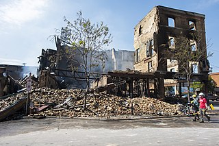
The FBI and ATF tracked 164 structure fires from arson that occurred May 27–30, 2020, during the George Floyd protests in Minneapolis–Saint Paul. Rioters started fires by igniting flammable materials within or next to buildings and in some cases by deploying Molotov cocktails. Property locations were damaged by spreading flames, heat, and smoke, and by suppressant waters from fire hoses and fire sprinkler systems. Many of the impacted structures suffered heavy damage or were destroyed, with some being reduced to piles of rubble after collapsing.


