
Socorro is a city in Socorro County in the U.S. state of New Mexico. It is in the Rio Grande Valley at an elevation of 4,579 feet (1,396 m). In 2010 the population was 9,051. It is the county seat of Socorro County. Socorro is located 74 miles (119 km) south of Albuquerque and 146 miles (235 km) north of Las Cruces.

Socorro is a city in El Paso County, Texas, United States. It is located on the north bank of the Rio Grande southeast of El Paso, and on the border of Mexico. El Paso adjoins it on the west and the smaller city of San Elizario on the southeast; small unincorporated areas of El Paso County separate it from the nearby municipalities of Horizon City to the north and Clint to the east. As of the 2020 census, the city population was 34,306. By the 2010 census, the number had grown to 32,013. As of July 1, 2019, the population estimate for the city from the U.S. Census was 34,370. It is part of the El Paso Metropolitan Statistical Area. The city is El Paso County's second-largest municipality, after El Paso. It has a council-manager type of government with five city council members. Socorro is the 93rd-largest community in Texas.
Tiwa is a group of two, possibly three, related Tanoan languages spoken by the Tiwa Pueblo, and possibly Piro Pueblo, in the U.S. state of New Mexico.
The Pueblo Revolt of 1680, also known as Popé's Rebellion or Popay's Rebellion, was an uprising of most of the indigenous Pueblo people against the Spanish colonizers in the province of Santa Fe de Nuevo México, larger than present-day New Mexico. The Pueblo Revolt killed 400 Spaniards and drove the remaining 2,000 settlers out of the province. The Spaniards reconquered New Mexico twelve years later.
Piro people were a Native American tribe who lived in New Mexico during the 16th and 17th century. (The Piros They lived in a number of pueblos in the Rio Grande Valley around modern Socorro, New Mexico, USA. The now extinct Piro language may have been a Tanoan language. Numbering several thousand at the time of first contact with the Spanish, by the time of the Pueblo Revolt in 1680 the Piro had been decimated by European-introduced diseases and Apache attacks and most of the survivors resettled near El Paso, Texas.

The Spanish Missions in Texas comprise a series of religious outposts established by Spanish Catholic Dominicans, Jesuits, and Franciscans to spread the Catholic doctrine among area Native Americans, but with the added benefit of giving Spain a toehold in the frontier land. The missions introduced European livestock, fruits, vegetables, and industry into the Texas area. In addition to the presidio and pueblo (town), the misión was one of the three major agencies employed by the Spanish crown to extend its borders and consolidate its colonial territories. In all, twenty-six missions were maintained for different lengths of time within the future boundaries of the state of Texas.
The Spanish Missions in New Mexico were a series of religious outposts in the Province of Santa Fe de Nuevo México — present day New Mexico. They were established by Franciscan friars under charter from the monarchs of the Spanish Empire and the government of the Viceroyalty of New Spain in a policy called Reductions to facilitate the conversion of Native Americans into Christianity.
Mission Valley is an area of El Paso, Texas, United States, which includes part of Eastside and all Lower Valley districts. It is the third largest area of the city, behind East El Paso and Central El Paso. Hawkins Road and Interstate 10 border the Mission Valley. This location is considered the oldest area of El Paso, dating back to the late 17th century when present-day Texas was under the rule of Nueva España.

The Camino Real de Tierra Adentro, also known as the Silver Route, was a Spanish 2,560-kilometre-long (1,590 mi) road between Mexico City and San Juan Pueblo, New Mexico, USA, that was used from 1598 to 1882. It was the northernmost of the four major "royal roads" that linked Mexico City to its major tributaries during and after the Spanish colonial era.

San Miguel de Socorro is the Catholic church in Socorro, New Mexico, built on the ruins of the old Nuestra Señora de Socorro mission. The old mission was built around 1626, but was destroyed in 1680 during the Pueblo Revolt. A portion of the adobe wall of the old church remains today and still can be seen behind glass just left of the altar. The building was listed on the National Register of Historic Places in 2016.
Teypana was the first pueblo to be called Socorro. This Piro pueblo was located close to present-day Socorro, New Mexico. A reference from 1598 suggests Teypana was on the west bank of the Rio Grande, downriver from the pueblo of Pilabó. Found in a partly flawed list of Piro pueblos, the reference is somewhat problematic. In 1598, Juan de Oñate and an advance party of his colonists were given food and water by the people of Teypana. In response, they named the settlement “Socorro”, which means “help” or “aid” in Spanish. By 1626, the name had become associated with the Piro pueblo of Pilabó, site of the first permanent mission in Piro territory, now buried under the town of Socorro, NM.
The Piro pueblo of Senecú was the southernmost occupied pueblo in New Mexico prior to the Pueblo Revolt of 1680. It was located on the west bank of the Rio Grande within sight of the Piro pueblo of San Pasqual. Colonial Spanish documents consistently place the pueblo opposite of Black Mesa, which is near San Marcial. Due to changes in the floodplain and the establishment of San Marcial, however, no surface remains of the pueblo survive in the area.
La Iglesia de Nuestra Señora la Reina de los Ángeles is a historic Catholic church in El Pueblo de los Ángeles Historical Monument in northern downtown Los Angeles, California. The church was founded by the Spanish in the early 19th century when modern-day California was under Spanish rule and known as Alta California in the Viceroyalty of New Spain.
By 1659 Piro Indians had begun settling in the area of Paso del Norte. The Mission Nuestra Señora de Guadalupe was established by Fray García for them. This mission became the southernmost of the New Mexico chain of missions along El Camino Real from Mexico City to Santa Fe. The original structure remains as a side chapel of the Cathedral of Juarez. The Piro settlement formed the core of the original Ciudad del El Paso del Norte, which later became La Ciudad de Benito Juárez and is in the present-day state of Chihuahua. The festival which began there, Tortugas Pueblo Fiesta of Our Lady of Guadalupe, moved later to Tortugas.

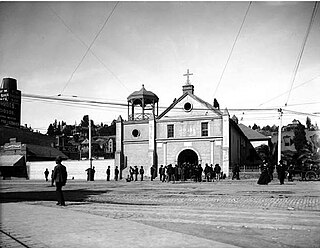
The original Franciscan mission, Nuestra Señora de la Concepción del Socorro, was founded in 1682 by the Franciscan order, to serve displaced Spanish families, American Indians from New Mexico, who fled the central New Mexico region during the Pueblo Revolt. The present Socorro Mission was constructed around 1840 to replace an earlier 18th-century mission destroyed in 1829 by flooding of the Rio Grande. The mission, constructed of adobe surfaced with stucco, is particularly notable for its interior. The finely painted and decorated beams, or vigas, are from the 18th-century mission and were reused when the present church was constructed. The massing, details and use of decorative elements of the Socorro Mission show strong relationships to the building traditions of 17th-century Spanish New Mexico.
Senecú is a small Mexican village, now on the outskirts of Ciudad Juárez, Chihuahua. It is at an altitude of 1,123 m. and lies within the Chihuahuan Desert ecosystem.
Polvadera is an unincorporated community and census-designated place in Socorro County in central New Mexico, United States. It is located on the west bank of the Rio Grande, near the mouth of the Rio Salado, and on the western spur of El Camino Real de Tierra Adentro.

The Ysleta Mission, located in the Ysleta del Sur Pueblo within the municipality of El Paso, Texas, is recognized as the oldest continuously operated parish in the State of Texas. The Ysleta community is also recognized as the oldest in Texas and claims to have the oldest continuously cultivated plot of land in the United States.
The Manso Indians were an indigenous people who lived along the Rio Grande, from the 16th to the 17th century. Present-day Las Cruces, New Mexico developed in this area. The Manso were one of the indigenous groups to be resettled at the Guadalupe Mission in what is now Ciudad Juarez, Mexico. Some of their descendants remain in the area to this day.
Tortugas, New Mexico or Tortugas Pueblo is a community in Doña Ana County, New Mexico, just outside of Las Cruces, New Mexico. As of the 2020 census, the CDP's population was 579.
