Pine Flat, Alabama | |
|---|---|
 Pine Flat, Alabama  Pine Flat, Alabama | |
| Coordinates: 31°50′21″N86°53′22″W / 31.83917°N 86.88944°W | |
| Country | United States |
| State | Alabama |
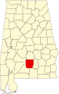
| County | Butler |
| Elevation | 210 ft (60 m) |
| Time zone | UTC-6 (Central (CST)) |
| • Summer (DST) | UTC-5 (CDT) |
| Area code | 334 |
| GNIS feature ID | 155363 [1] |
Pine Flat, also known as Dogwood Flat, is an unincorporated community in Butler County, Alabama, United States, located on Alabama State Route 10.