Piotrowice-Ochojec

Last updated
Piotrowice-Ochojec
Osiedle Targowisko.jpg
Targowisko housing estate
Katowice-Piotrowice-Ochojec.svg
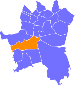
Location of Piotrowice-Ochojec within Katowice
Coordinates: 50°12′33.2″N18°58′50.9″E / 50.209222°N 18.980806°E / 50.209222; 18.980806
CountryFlag of Poland.svg  Poland
Voivodeship Silesian
County/City Katowice
Area
  Total1,208 km2 (466 sq mi)
Population
 (2007)
  Total25,110
  Density21/km2 (54/sq mi)
Time zone UTC+1 (CET)
  Summer (DST) UTC+2 (CEST)
Area code (+48) 032

Piotrowice-Ochojec is a district of Katowice, Poland. It has an area of 12,08 km2 and in 2007 had 25,110 inhabitants. [1]

Contents

History

The area became part of the emerging Polish state in the 10th century. Following the fragmentation of Poland, it formed part of various smaller duchies, including the duchies of Silesia and Opole, later falling under Bohemian suzerainty.

Piotrowice

The oldest settlement in the area of what are now the districts Piotrowice, Podlesie and Zarzecze was Uniczowy, a village that existed in the 12th century and was first mentioned in the year 1287.

During the political upheaval caused by Matthias Corvinus, the land around Pszczyna was overtaken by Casimir II, Duke of Cieszyn, who sold it in 1517 to the Hungarian magnates of the Thurzó family, forming the Pless state country. In the accompanying sales document issued on 21 February 1517 the village was mentioned as Petrowicze Vnicziowy. [2] The Kingdom of Bohemia in 1526 became part of the Habsburg monarchy. In the War of the Austrian Succession most of Silesia was conquered by the Kingdom of Prussia, including the village.

Uniczowy was somewhat replaced by Piotrowice in the 17th century. It was merged with Katowice in 1939.

During the German occupation of Poland (World War II), on January 18, 1940, the German police carried out a massacre of 39 Polish farmers, craftsmen and workers in Piotrowice (see Nazi crimes against the Polish nation ). [3]

Ochojec

The area of Ochojec was covered with forests until the middle of the 17th century. Around 1650 a folwark was established here by Promnitz family, the owners of Pless (Pszczyna). The small settlement emerged in 1770. The meaningful growth of Ochojec began after World War I.

Related Research Articles

<span class="mw-page-title-main">Zarzecze, Katowice</span> Katowice District in Silesian Voivodeship, Poland

Zarzecze is a district of Katowice in southern Poland. It has an area of 5.1 km2 and in 2007 had 1,902 inhabitants.

<span class="mw-page-title-main">Podlesie, Katowice</span> Katowice District in Silesian Voivodeship, Poland

Podlesie is a district of Katowice. It has an area of 8.28 km2 and in 2007 had 5,240 inhabitants.

<span class="mw-page-title-main">Brzeźce</span> Village in Silesian Voivodeship, Poland

Brzeźce is a village in the administrative district of Gmina Pszczyna, within Pszczyna County, Silesian Voivodeship, in southern Poland. It lies approximately 10 kilometres (6 mi) west of Pszczyna and 35 km (22 mi) south-west of the regional capital Katowice.

<span class="mw-page-title-main">Czarków, Pszczyna County</span> Village in Silesian Voivodeship, Poland

Czarków is a village in the administrative district of Gmina Pszczyna, within Pszczyna County, Silesian Voivodeship, in southern Poland. It lies approximately 5 kilometres (3 mi) north-west of Pszczyna and 27 km (17 mi) south of the regional capital Katowice.

<span class="mw-page-title-main">Jankowice, Pszczyna County</span> Village in Silesian Voivodeship, Poland

Jankowice is a village in the administrative district of Gmina Pszczyna, within Pszczyna County, Silesian Voivodeship, in southern Poland. It lies approximately 4 km north-east of Pszczyna and 28 km south of the regional capital Katowice.

<span class="mw-page-title-main">Łąka, Silesian Voivodeship</span> Village in Silesian Voivodeship, Poland

Łąka is a village in the administrative district of Gmina Pszczyna, within Pszczyna County, Silesian Voivodeship, in southern Poland. It lies approximately 4 kilometres (2 mi) south-west of Pszczyna and 32 km (20 mi) south of the regional capital Katowice.

<span class="mw-page-title-main">Piasek</span> Village in Silesian Voivodeship, Poland

Piasek is a village in the administrative district of Gmina Pszczyna, within Pszczyna County, Silesian Voivodeship, southern Poland. It lies approximately 4 km north of Pszczyna and 27 km south of the regional capital Katowice.

<span class="mw-page-title-main">Rudołtowice</span> Village in Silesian Voivodeship, Poland

Rudołtowice is a village in the administrative district of Gmina Pszczyna, within Pszczyna County, Silesian Voivodeship, in southern Poland. It lies approximately 5 kilometres (3 mi) south-east of Pszczyna and 32 km (20 mi) south of the regional capital Katowice.

<span class="mw-page-title-main">Studzienice, Silesian Voivodeship</span> Village in Silesian Voivodeship, Poland

Studzienice is a village in the administrative district of Gmina Pszczyna, within Pszczyna County, Silesian Voivodeship, in southern Poland.

<span class="mw-page-title-main">Wisła Wielka</span> Village in Silesian Voivodeship, Poland

Wisła Wielka is a village in the administrative district of Gmina Pszczyna, within Pszczyna County, Silesian Voivodeship, in southern Poland. It lies approximately 8 kilometres (5 mi) south-west of Pszczyna and 35 km (22 mi) south of the regional capital Katowice.

<span class="mw-page-title-main">Grzawa</span> Village in Silesian Voivodeship, Poland

Grzawa is a village in the administrative district of Gmina Miedźna, within Pszczyna County, Silesian Voivodeship, in southern Poland.

<span class="mw-page-title-main">Miedźna</span> Village in Silesian Voivodeship, Poland

Miedźna is a village in Pszczyna County, Silesian Voivodeship, in southern Poland. It is the seat of the gmina called Gmina Miedźna. It lies approximately 8 kilometres (5 mi) east of Pszczyna and 30 km (19 mi) south of the regional capital Katowice.

<span class="mw-page-title-main">Kobiór</span> Village in Silesian Voivodeship, Poland

Kobiór is a village in Pszczyna County, Silesian Voivodeship, in southern Poland. It is the seat of the gmina called Gmina Kobiór. It lies approximately 9 kilometres (6 mi) north of Pszczyna and 22 km (14 mi) south of the regional capital Katowice.

<span class="mw-page-title-main">Wola, Silesian Voivodeship</span> Village in Silesian Voivodeship, Poland

Wola is a village in the administrative district of Gmina Miedźna, within Pszczyna County, Silesian Voivodeship, in southern Poland. It lies approximately 14 kilometres (9 mi) east of Pszczyna and 28 km (17 mi) south of the regional capital Katowice.

<span class="mw-page-title-main">Krzyżowice, Silesian Voivodeship</span> Village in Silesian Voivodeship, Poland

Krzyżowice is a village in the administrative district of Gmina Pawłowice, within Pszczyna County, Silesian Voivodeship, in southern Poland. It lies approximately 5 kilometres (3 mi) north-west of Pawłowice, 20 km (12 mi) west of Pszczyna, and 38 km (24 mi) south-west of the regional capital Katowice.

<span class="mw-page-title-main">Warszowice</span> Village in Silesian Voivodeship, Poland

Warszowice is a village in the administrative district of Gmina Pawłowice, within Pszczyna County, Silesian Voivodeship, in southern Poland. It lies approximately 17 kilometres (11 mi) west of Pszczyna and 35 km (22 mi) south-west of the regional capital Katowice.

Radostowice is a village in the administrative district of Gmina Suszec, within Pszczyna County, Silesian Voivodeship, in southern Poland. It lies approximately 8 kilometres (5 mi) east of Suszec, 6 km (4 mi) north-west of Pszczyna, and 27 km (17 mi) south of the regional capital Katowice.

<span class="mw-page-title-main">Kryry, Poland</span> Village in Silesian Voivodeship, Poland

Kryry is a village in the administrative district of Gmina Suszec, within Pszczyna County, Silesian Voivodeship, in southern Poland. It lies approximately 4 kilometres (2 mi) south of Suszec, 11 km (7 mi) west of Pszczyna, and 32 km (20 mi) south-west of the regional capital Katowice.

<span class="mw-page-title-main">Stara Wieś, Pszczyna</span> District of Pszczyna in Silesian Voivodeship, Poland

Stara Wieś is a dzielnica (district) of Pszczyna, Silesian Voivodeship, southern Poland.

<span class="mw-page-title-main">Brzezinka, Mysłowice</span> Mysłowice District in Silesian Voivodeship, Poland

Brzezinka is a dzielnica (district) of Mysłowice, Silesian Voivodeship, southern Poland. It was previously an independent village and gmina, but was absorbed by Mysłowice in 1951.

References

  1. Urząd Miasta Katowice. "Katowice - Studium uwarunkowań i kierunków zagospodarowania przestrzennego" (PDF) (in Polish). Archived from the original (PDF) on 2011-11-04. Retrieved 2011-06-16.
  2. Musioł, Ludwik (1930). "Dokument sprzedaży księstwa pszczyńskiego z dn. 21. lutego 1517 R." Roczniki Towarzystwa Przyjaciół Nauk na Śląsku. R. 2. Katowice: nakł. Towarzystwa ; Drukiem K. Miarki: 235–237. Archived from the original on 11 September 2014. Retrieved 12 September 2014.
  3. Wardzyńska, Maria (2009). Był rok 1939. Operacja niemieckiej policji bezpieczeństwa w Polsce. Intelligenzaktion (in Polish). Warszawa: IPN. p. 142.