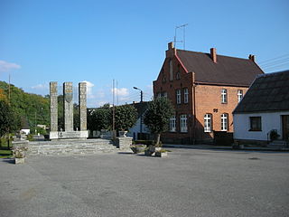
Miasteczko Krajeńskie is a town in Piła County, Greater Poland Voivodeship, in west-central Poland. It is the seat of the gmina called Gmina Miasteczko Krajeńskie. It lies approximately 20 kilometres (12 mi) south-east of Piła and 77 km (48 mi) north of the regional capital Poznań.

Borek Wielkopolski is a town in Poland, in the Gostyń County in the Greater Poland Voivodeship, with 2,485 inhabitants as of June 2021.

Rzgów is a town in Łódź East County, Łódź Voivodeship, in central Poland, with 3,382 inhabitants (2020). It is situated on the Ner River within the Sieradz Land. The town is a member of Cittaslow.

Jankowo Dolne is a village in the administrative district of Gmina Gniezno, within Gniezno County, Greater Poland Voivodeship, in west-central Poland. It lies approximately 8 kilometres (5 mi) east of Gniezno and 56 km (35 mi) east of the regional capital Poznań.

Modliszewo is a village in the administrative district of Gmina Gniezno, within Gniezno County, Greater Poland Voivodeship, in west-central Poland. It lies approximately 8 kilometres (5 mi) north of Gniezno and 52 km (32 mi) north-east of the regional capital Poznań.

Kędzierzyn is a village in the administrative district of Gmina Niechanowo, within Gniezno County, Greater Poland Voivodeship, in west-central Poland. It lies approximately 5 kilometres (3 mi) north of Niechanowo, 7 km (4 mi) south-east of Gniezno, and 54 km (34 mi) east of the regional capital Poznań.
Malenin is a village in the administrative district of Gmina Witkowo, within Gniezno County, Greater Poland Voivodeship, in west-central Poland. It lies approximately 4 kilometres (2 mi) south-west of Witkowo, 16 km (10 mi) south-east of Gniezno, and 56 km (35 mi) east of the regional capital Poznań.

Jaraczewo is a town in Jarocin County, Greater Poland Voivodeship, in west-central Poland. It is the seat of the gmina called Gmina Jaraczewo. It lies approximately 14 kilometres (9 mi) west of Jarocin and 55 km (34 mi) south-east of the regional capital Poznań.
Kuczewola is a village in the administrative district of Gmina Szczytniki, within Kalisz County, Greater Poland Voivodeship, in central Poland. It lies approximately 5 kilometres (3 mi) west of Szczytniki, 17 km (11 mi) south-east of Kalisz, and 124 km (77 mi) south-east of the regional capital Poznań.

Bralin is a village in Kępno County, Greater Poland Voivodeship, in west-central Poland. It is the seat of the gmina called Gmina Bralin. It lies approximately 6 kilometres (4 mi) west of Kępno and 142 km (88 mi) south-east of the regional capital Poznań.

Chojęcin is a village in the administrative district of Gmina Bralin, within Kępno County, Greater Poland Voivodeship, in west-central Poland. It lies approximately 4 kilometres (2 mi) south-east of Bralin, 3 km (2 mi) south-west of Kępno, and 145 km (90 mi) south-east of the regional capital Poznań.
Barbarka is a village in the administrative district of Gmina Golina, within Konin County, Greater Poland Voivodeship, in west-central Poland. It lies approximately 7 kilometres (4 mi) south-west of Golina, 17 km (11 mi) west of Konin, and 78 km (48 mi) east of the regional capital Poznań.

Rzuchów is a village in the administrative district of Gmina Dąbie, within Koło County, Greater Poland Voivodeship, in central Poland. It lies approximately 9 kilometres (6 mi) north-west of Dąbie, 11 km (7 mi) south-east of Koło, and 127 km (79 mi) east of the regional capital Poznań.

Kościelec is a village in Koło County, Greater Poland Voivodeship, in central Poland. It is the seat of the gmina called Gmina Kościelec. It lies approximately 6 kilometres (4 mi) south-west of Koło and 116 km (72 mi) east of the regional capital Poznań.

Przygodzice is a village in Ostrów Wielkopolski County, Greater Poland Voivodeship, in west-central Poland. It is the seat of the gmina called Gmina Przygodzice. It lies approximately 5 kilometres (3 mi) south of the town of Ostrów Wielkopolski.

Morzewo is a village in the administrative district of Gmina Kaczory, within Piła County, Greater Poland Voivodeship, in west-central Poland. It lies approximately 2 kilometres (1 mi) south of Kaczory, 13 km (8 mi) south-east of Piła, and 76 km (47 mi) north of the regional capital Poznań.

Chocz is a town in Pleszew County, Greater Poland Voivodeship, in west-central Poland. It is the seat of the gmina called Gmina Chocz. It lies approximately 11 kilometres (7 mi) north-east of Pleszew and 81 km (50 mi) south-east of the regional capital Poznań.
Markowice is a village in the administrative district of Gmina Kleszczewo, within Poznań County, Greater Poland Voivodeship, in west-central Poland. It lies approximately 6 kilometres (4 mi) south-east of Kleszczewo and 25 km (16 mi) south-east of the regional capital Poznań.

Mieścisko is a town in Wągrowiec County, Greater Poland Voivodeship, in west-central Poland. It is the seat of the gmina called Gmina Mieścisko. It lies approximately 11 kilometres (7 mi) south-east of Wągrowiec and 48 km (30 mi) north-east of the regional capital Poznań. It is situated on the Wełna River.

Podlesie Kościelne is a village in the administrative district of Gmina Mieścisko, within Wągrowiec County, Greater Poland Voivodeship, in west-central Poland. It lies approximately 11 kilometres (7 mi) south-east of Wągrowiec and 46 km (29 mi) north-east of the regional capital Poznań.


