Piriápolis

Last updated • 3 min readFrom Wikipedia, The Free Encyclopedia
Piriápolis
City & Municipality
Piriapolis from Cerro San Antonio.jpg
Uruguay location map.svg
Red pog.svg
Piriápolis
Coordinates: 34°54′0″S55°17′0″W / 34.90000°S 55.28333°W / -34.90000; -55.28333
CountryFlag of Uruguay.svg  Uruguay
Department Flag of Maldonado Department.png  Maldonado
Founded1890
Founded byFrancisco Piria
Area
  Total25 km2 (10 sq mi)
Population
 (2011 Census)
  Total8,830
Time zone UTC -3
Postal code
20200
Dial plan +598 443 (+5 digits)
Climate Cfa

Piriápolis is a city in the Maldonado Department of Uruguay. It is an important summer resort in the country, predating the larger and better known resort town of Punta del Este. Because it is mainly used as a resort, it has a relatively small permanent population for a city of its size.

Contents

Piriápolis is also the name of the municipality to which the city belongs. It includes the following zones: Piriápolis, Playa Grande, Playa Hermosa, Playa Verde, Punta Colorada, San Francisco, Punta Negra, Sauce de Portezuelo, Ocean Park, Barra de Portezuelo, La Capuera, Puntas de la Sierra, La Falda, Miramar, Colonia V. Suárez, Sierras del Tirol.

Geography

It is located on the coast of Río de la Plata, on Route 10 and its intersection with Route 37. It is about 100 kilometres (62 mi) east of the national capital, Montevideo (via Ruta Interbalnearia and Route 37).

History

Piriápolis was founded on 5 November 1890 as El Balneario del Porvenir (the Resort of the Future). In 1890, businessman Francisco Piria had bought a very big stretch of land, including the hills Cerro Pan de Azúcar, Cerro del Inglés and Cerro del Toro, all the way south to the beach. In 1897 he finished the construction of his personal residence, Piria´s Castle, in 1905 the construction of "Hotel Piriápolis", today known as "Colonia Escolar de Vacaciones", in 1910 he constructed the coastal avenue Rambla de los Argentinos finished in 1916. From 1920 to 1930 he constructed the Argentino Hotel, one of the biggest hotels of South America of the times. When Piria died in 1933, his natural and legal children started fighting each other over the inheritance.[ citation needed ]

On 10 September 1937, the status of the populated centre was elevated to "Pueblo" (village) by the Act of Ley Nº 9.687. [1] On 21 June 1960 its status was further elevated to "Ciudad" (city) by the Act of Ley Nº 12.736. [2]

Population

In 2011 Piriápolis had a population of 8,830 permanent inhabitants [3] and 8,489 dwellings. [4] According to the Intendencia Departamental de Maldonado, the municipality of Piriápolis has a population of 14,000. [5]

Location map of the municipality of Piriapolis MunMaldPiria.svg
Location map of the municipality of Piriápolis
YearPopulationDwellings
19634,5462,620
19755,2403,661
19855,8784,289
19967,5705,640
20047,8997,123
20118,8308,489

Source: Instituto Nacional de Estadística de Uruguay [6] [7]

Places of interest

Piria's Castle. Castillo Piria.jpg
Piria's Castle.
The Hotel Argentino, during the 2008 Piriapolis Grand Prix. 2008 Piriapolis Grand Prix - Argentino Hotel.jpg
The Hotel Argentino, during the 2008 Piriápolis Grand Prix.
Hotel Colon de Piriapolis. Hotel Colon Piriapolis.jpg
Hotel Colón de Piriápolis.
Piriapolis coast in winter low season. Piriapolis, Maldonado.jpg
Piriápolis coast in winter low season.
Punta Fria from the San Antonio hill Piriapolis 4.JPG
Punta Fría from the San Antonio hill

The city is centered on the Rambla de los Argentinos, a waterfront promenade. With a tourism-centered economy, Piriápolis has opulent hotels, large casinos, an active nightlife scene, and public parks. The Templo de San Antonio, situated atop one of the hills surrounding the city, can be reached by chair lift and offers a panoramic view of the coast. For more adventurous travelers, Uruguay's third-highest point, the Cerro Pan de Azúcar, can be found 10 km outside of town. The peak presents a challenging climb as well as a nature reserve. Boat tours and saltwater fishing are available at the Piriápolis port.[ citation needed ]

The Castle of Piria, near Piriápolis, is open to the public. The poet Julio Herrera y Reissig resided at the Castle for a period.

Places of worship

In fiction

See also

Related Research Articles

<span class="mw-page-title-main">Punta del Este</span> City in Uruguay

Punta del Este is a seaside city and peninsula on the Atlantic Coast in the Maldonado Department of southeastern Uruguay. Starting as a small town, Punta del Este later became internationally known as a resort for the Latin and North American jet set and tourists. The city has been referred to as "the Monaco of the South", "The Pearl of the Atlantic", "the Hamptons of South America","the Miami Beach of South America", or "the St. Tropez of South America".

<span class="mw-page-title-main">Maldonado Department</span> Department of Uruguay

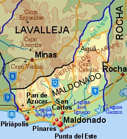
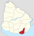
The Maldonado Department, with an area of 4,793 km2 (1,851 sq mi) and 164,300 inhabitants (2011), is located to the southeast of Uruguay. Its capital is Maldonado.

<span class="mw-page-title-main">Pan de Azúcar, Uruguay</span> City Municipality in Maldonado, Uruguay

Pan de Azúcar is a city in the southwest of the Maldonado Department in Uruguay. It takes its name from a nearby hill, topped by a huge cross.

<span class="mw-page-title-main">Maldonado, Uruguay</span> Capital city in Maldonado, Uruguay

Maldonado is the capital of Maldonado Department of Uruguay. As of the census of 2021, it is the ninth most populated city in the country.

<span class="mw-page-title-main">Punta Colorada</span> Resort in Maldonado Department, Uruguay

Punta Colorada is a small peninsula and a resort in the Maldonado Department of Uruguay.

La Floresta is a city and resort on the Costa de Oro of the Canelones Department in Uruguay.

<span class="mw-page-title-main">Aiguá</span> City & Municipality in Maldonado, Uruguay

Aiguá is a city of the Maldonado Department in Uruguay. Its name means running water in the Guaraní language. It is also the name of the municipality to which the city belongs. It includes the following zones: Aiguá, Sauce de Aiguá, Sarandí de Aiguá, Alférez, Valdivia, Salamanca, Coronilla, Rincón de Aparicio, Los Talas, Paso de los Talas.

<span class="mw-page-title-main">Tourism in Uruguay</span>

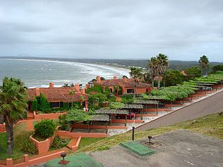
Tourism in Uruguay is an important part of the nation's economy.

<span class="mw-page-title-main">Cerro Pan de Azúcar</span> Mountain in Maldonado Department, Uruguay

Cerro Pan de Azúcar is among the top 10 highest points of Uruguay, with an altitude of 423 metres (1,387.8 ft).

<span class="mw-page-title-main">Barros Blancos</span> City in Canelones, Uruguay

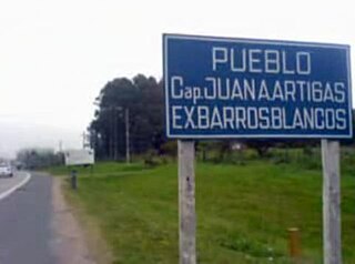
Barros Blancos is a city in the Canelones Department of southern Uruguay. In 1976, it had been renamed to Juan Antonio Artigas, after commanding officer Juan Antonio Artigas, grandfather of the national hero José Gervasio Artigas, but the old name was reinstated in 2007.

<span class="mw-page-title-main">Garzón, Uruguay</span> Village in Maldonado, Uruguay

Garzón is a village in the Maldonado Department of southeastern Uruguay.

<span class="mw-page-title-main">Route 10 (Uruguay)</span> Road in Uruguay

Route 10 is a national route of Uruguay. In 1983, it was assigned the name Juan Díaz de Solís, honouring the Spanish navigator.

<span class="mw-page-title-main">Ruta Interbalnearia</span> Road in Uruguay

Ruta Interbalnearia or Ruta Líber Seregni is a national route of Uruguay. It connects Montevideo with Punta del Este to the east along the coast. The road is approximately 90 kilometres (56 mi) in length. It is marked on maps and signs as IB.

<span class="mw-page-title-main">Punta Ballena</span> Resort in Maldonado Department, Uruguay

Punta Ballena is a small peninsula (punta) and a resort (balneario), as well as an important tourist attraction on the coast of Río de la Plata in the Maldonado Department of southeastern Uruguay. It comprises an approximately 12 kilometres (7.5 mi) long stripe of beaches and landforms and extends on both sides of Route 10.

<span class="mw-page-title-main">Punta Negra, Uruguay</span> Resort in Maldonado Department, Uruguay

Punta Negra is a small peninsula (punta) and a resort (balneario) in the Maldonado Department of Uruguay.

Sauce de Portezuelo is a resort (balneario) in the Maldonado Department of Uruguay.

<span class="mw-page-title-main">Chihuahua, Uruguay</span> Resort in Maldonado Department, Uruguay

Chihuahua is a resort (balneario) in the Maldonado Department of Uruguay.

Ocean Park is a resort (balneario) in the Maldonado Department of Uruguay.

La Estación de cría y fauna autóctona Cerro Pan de Azúcar is a nature park and zoo located close to the coastal city of Piriápolis in the Department of Maldonado, in southeastern Uruguay. The park belongs to the Municipal Administration Department of Maldonado. Some 250 examples of 53 species of Uruguayan animals are housed within an area of 86 hectares, surrounded by native trees and bushes. 300,000 people visit the park annually, many of which are groups of students.

<span class="mw-page-title-main">Municipality of Maldonado</span> Municipality in Maldonado, Uruguay

The Municipality of Maldonado is one of the eight municipalities of Maldonado Department, Uruguay. It was created by Law N° 18653 of 15 March 2010.

References

  1. "Ley Nº 9.687". República Oriental del Uruguay, Poder Legislativo. 1937. Retrieved 8 September 2012.
  2. "Ley Nº 12.736". República Oriental del Uruguay, Poder Legislativo. 1960. Archived from the original on 6 October 2014. Retrieved 8 September 2012.
  3. "Censos 2011 Cuadros Maldonado". INE. 2012. Retrieved 25 August 2012.
  4. "Censos 2011 Maldonado". INE. 2012. Retrieved 25 August 2012.
  5. "Presupuesto-2011-2015". Intendencia Departamnetal de Maldonado. 2012. Archived from the original on 24 April 2011. Retrieved 11 September 2012.
  6. "Statistics of urban localities (1963–2004)" (PDF). INE. 2012. Retrieved 8 September 2012.
  7. "1963–1996 Statistics / P" (DOC). Instituto Nacional de Estadística de Uruguay. 2004. Retrieved 26 July 2011.