Pleasant View, Colorado

Last updated

Pleasant View, Colorado
Pleasant View, Colorado.JPG
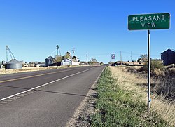
Looking north along Highway 491 in Pleasant View
USA Colorado location map.svg
Red pog.svg
Pleasant View
Usa edcp location map.svg
Red pog.svg
Pleasant View
Coordinates: 37°35′18″N108°45′57″W / 37.58833°N 108.76583°W / 37.58833; -108.76583
Country Flag of the United States.svg  United States
State Flag of Colorado.svg  Colorado
County Montezuma [1]
Elevation
[1]
6,913 ft (2,107 m)
Time zone UTC-7 (MST)
  Summer (DST) UTC-6 (MDT)
ZIP code [2]
81331
Area code 970
GNIS feature ID 0176857

Pleasant View is an unincorporated community and a U.S. Post Office located in Montezuma County, Colorado, United States. The Pleasant View Post Office has the ZIP Code 81331. [2]

Contents

Pleasant View should not be confused with the census-designated places in Jefferson County known as West Pleasant View and East Pleasant View.

History

Several historic places near or in Pleasant View are on the Colorado State Register of Historic Properties or the National Register of Historic Places: [3] [4]

Geography

Pleasant View is located at 37°35′18″N108°45′57″W / 37.58833°N 108.76583°W / 37.58833; -108.76583 (37.588391,-108.765850).

Demographics

The median income for a household was $16,631 in 2009. In 2000, the median income for a household was $45,897.

The median resident age was 38.6 years. [5]

Education

Pleasant View Public Schools are part of the Montezuma-Cortez School District RE-1. The district has one preschool, five elementary schools, one middle school and one high school.

Pleasant View Elementary School is located in Pleasant View. The other schools in the district are located in Cortez, and include Montezuma-Cortez RE-1 Pre-School, Kemper Elementary School, Lewis-Arriola Elementary School, Manaugh Elementary School, Mesa Elementary Schools, Cortez Middle School and Montezuma-Cortez High School. The high school mascot is the Panthers.

See also

Related Research Articles

<span class="mw-page-title-main">Montezuma County, Colorado</span> County in Colorado, United States

Montezuma County is a county located in the U.S. state of Colorado. As of the 2020 census, the population was 25,849. The county seat is Cortez.

<span class="mw-page-title-main">Dolores County, Colorado</span> County in Colorado, United States

Dolores County is a county located in the U.S. state of Colorado. As of the 2020 census, the population was 2,326. The county seat is Dove Creek.

<span class="mw-page-title-main">Las Animas, Colorado</span> City in Colorado, United States

Las Animas is the statutory city that is the county seat, the most populous community, and the only incorporated municipality in Bent County, Colorado, United States. The city population was 2,300 at the 2020 United States Census. Las Animas is located on the Arkansas River, just west of its confluence with the Purgatoire River, in southeast Colorado east of Pueblo, near the historic Bent's Fort.

<span class="mw-page-title-main">Dove Creek, Colorado</span> Town in Colorado, United States

Dove Creek is a statutory town that is the county seat and the most populous municipality of Dolores County, Colorado, United States. The town population was 635 at the 2020 United States Census. The community takes its name from the nearby Dove Creek. Dove Creek is the self-proclaimed Pinto Bean Capital of the World.

<span class="mw-page-title-main">Cortez, Colorado</span> City in Colorado, United States

Cortez is a home rule municipality that is the county seat and the most populous municipality of Montezuma County, Colorado, United States. The city population was 8,766 at the 2020 United States Census.

<span class="mw-page-title-main">Dolores, Colorado</span> Town in Montezuma County, Colorado, United States

Dolores is a Statutory Town located in Montezuma County, Colorado, United States. The town population was 885 at the 2020 United States Census.

<span class="mw-page-title-main">Mancos, Colorado</span> Town in Colorado, United States

Mancos is a statutory town in Montezuma County, Colorado, United States. The population was 1,196 at the 2020 census, down from 1,336 in 2010.

<span class="mw-page-title-main">Yucca House National Monument</span> Archaeological site in Colorado, United States

Yucca House National Monument is a United States National Monument located in Montezuma County, Colorado between the towns of Towaoc and Cortez, Colorado. Yucca House is a large, unexcavated Ancestral Puebloan archaeological site.

<span class="mw-page-title-main">Hawkins Preserve</span> Conservation easement in Colorado

Hawkins Preserve is a 122-acre (0.49 km2) property within the city limits of Cortez, Colorado. It is protected by a conservation easement held by the Montezuma Land Conservancy.

<span class="mw-page-title-main">Canyons of the Ancients National Monument</span> Monument protecting significant sites of ancient Native Americans

Canyons of the Ancients National Monument is a national monument protecting an archaeologically significant landscape located in the southwestern region of the U.S. state of Colorado. The monument's 176,056 acres (71,247 ha) are managed by the Bureau of Land Management, as directed in the presidential proclamation which created the site on June 9, 2000. Canyons of the Ancients National Monument is part of the National Landscape Conservation System, better known as the National Conservation Lands. This system comprises 32 million acres managed by the Bureau of Land Management to conserve, protect, and restore these nationally significant landscapes recognized for their outstanding cultural, ecological, and scientific values. Canyons of the Ancients encompasses and surrounds three of the four separate sections of Hovenweep National Monument, which is administered by the National Park Service. The monument was proclaimed in order to preserve the largest concentration of archaeological sites in the United States, primarily Ancestral Puebloan ruins. As of 2022, over 8,500 individual archeological sites had been documented within the monument.

<span class="mw-page-title-main">Whitewater, Colorado</span> Unincorporated community in Colorado, United States

Whitewater is an unincorporated community with a U.S. Post Office in Mesa County, Colorado, United States, just south of Grand Junction. The Whitewater Post Office has the ZIP Code 81527. It is located on the banks of the Gunnison River near the confluences with Whitewater Creek and Kannah Creek to the south.

<span class="mw-page-title-main">Yellow Jacket, Colorado</span> Unincorporated community in Colorado, United States

Yellow Jacket is an unincorporated community and a U.S. post office located in Montezuma County, Colorado, United States. The Yellow Jacket post office has the ZIP Code 81335.

<span class="mw-page-title-main">Lowry Pueblo</span> Archaeological site in Colorado, United States

The Lowry Pueblo is an Ancestral Puebloan archaeological site located in Canyons of the Ancients National Monument near Pleasant View, Colorado, United States. The pueblo was constructed around 1060 AD atop abandoned pithouses from an earlier period of occupation. It was occupied by 40 to 100 people at a time for 165 years. The site is one of the northernmost to be associated with the Puebloan cultures. The site was declared a National Historic Landmark in 1964.

<span class="mw-page-title-main">National Register of Historic Places listings in Montezuma County, Colorado</span> List of National Register of Historic Places in Montezuma County, Colorado, United States

This is a list of the National Register of Historic Places listings in Montezuma County, Colorado.

Lowry House may refer to:

<span class="mw-page-title-main">Trail of the Ancients</span> National Scenic Byways in Arizona, Colorado, New Mexico, and Utah, United States

The Trail of the Ancients is a collection of National Scenic Byways located in the U.S. Four Corners states of Utah, Colorado, New Mexico, and Arizona. These byways comprise:

<span class="mw-page-title-main">Ansel Hall Ruin</span> Archaeological site in Colorado, United States

The Ansel Hall Ruin, also known as Cahone Ruin, is located in Cahone, Dolores County, Colorado. A pre-historic ruins from the Pueblo II period, the Northern San Juan pueblo was added to the National Register of Historic Places in 1997.

Joe Ben Wheat Site Complex is a set of archaeological sites dated from AD 600 to 1300 that are located near Yellow Jacket in Montezuma County, Colorado. The complex is also known by its collective site ID of 5MT16722. In 2004, the Joe Ben Wheat Site Complex was added to the National Register of Historic Places.

<span class="mw-page-title-main">Montezuma-Cortez High School</span> Public high school in Cortez, Colorado, United States

Montezuma-Cortez High School (M-CHS) is a public senior high school located in Cortez, Colorado, United States, serving 721 students in grades 9–12. It is part of the Montezuma-Cortez School District RE-1.

References

  1. 1 2 "US Board on Geographic Names". United States Geological Survey. October 25, 2007. Retrieved January 31, 2008.
  2. 1 2 "ZIP Code Lookup" (JavaScript/HTML). United States Postal Service. January 2, 2007. Retrieved January 2, 2007.
  3. National & State Registers for Montezuma County, Colorado. Archived 2012-04-24 at the Wayback Machine Colorado Historical Society, Office of Archaeology and Historic Preservation. Retrieved 10-8-2011.
  4. <<</state.html National Register of Historic Places in <<< County American Dreams, Inc. Retrieved 2011-10-6.
  5. "Pleasant View, Colorado". City-Data.com. Retrieved July 7, 2012.