Yellow Jacket, Colorado

Last updated

Yellow Jacket, Colorado
Yellow Jacket, Colorado.JPG
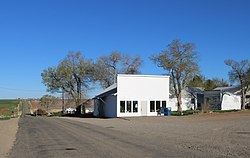
County Road Y (left) and the post office in Yellow Jacket.
USA Colorado location map.svg
Red pog.svg
Yellow Jacket
Usa edcp location map.svg
Red pog.svg
Yellow Jacket
Coordinates: 37°31′58″N108°43′11″W / 37.53278°N 108.71972°W / 37.53278; -108.71972
Country Flag of the United States.svg  United States
State Flag of Colorado.svg  Colorado
County Montezuma County [1]
Elevation
[1]
6,900 ft (2,103 m)
Time zone UTC-7 (MST)
  Summer (DST) UTC-6 (MDT)
ZIP code [2]
81335
Area code 970
GNIS feature ID 0176860

Yellow Jacket is an unincorporated community and a U.S. post office located in Montezuma County, Colorado, United States. The Yellow Jacket post office has the ZIP Code 81335. [2]

Contents

Geography

Yellow Jacket is located at 37°31′58″N108°43′11″W / 37.53278°N 108.71972°W / 37.53278; -108.71972 (37.532871,-108.719845).

History

A post office called Yellow Jacket has been in operation since 1914. [3] The community was named for the abundance of yellow jackets near the original town site. [4]

There are a number of prehistoric archaeological sites of the Ancient Pueblo People (Anasazi) during the Pueblo II Era and Pueblo III Eras near Yellow Jacket that are listed on the National Register of Historic Places and the Colorado State Register of Historic Properties: [5] [6]

See also

Related Research Articles

<span class="mw-page-title-main">Dove Creek, Colorado</span> Town in Colorado, United States

Dove Creek is a statutory town that is the county seat and the most populous municipality of Dolores County, Colorado, United States. The town population was 635 at the 2020 United States Census. The community takes its name from the nearby Dove Creek. Dove Creek is the self-proclaimed Pinto Bean Capital of the World.

<span class="mw-page-title-main">Cortez, Colorado</span> City in Colorado, United States

Cortez is a home rule municipality that is the county seat and the most populous municipality of Montezuma County, Colorado, United States. The city population was 8,766 at the 2020 United States Census.

<span class="mw-page-title-main">Dolores, Colorado</span> Town in Montezuma County, Colorado, United States

Dolores is a Statutory Town located in Montezuma County, Colorado, United States. The town population was 885 at the 2020 United States Census.

<span class="mw-page-title-main">Mancos, Colorado</span> Town in Colorado, United States

Mancos is a statutory town in Montezuma County, Colorado, United States. The population was 1,196 at the 2020 census, down from 1,336 in 2010.

<span class="mw-page-title-main">Uravan, Colorado</span> Uranium mining ghost town in Montrose County, Colorado

Uravan is a former uranium mining town in western Montrose County, Colorado, United States, which still appears on some maps. The town was a company town established by U. S. Vanadium Corporation in 1936 to extract the rich vanadium ore in the region. As a byproduct of vanadium extraction, small amounts of uranium were also produced, at the time mostly used as a yellow pigment for ceramics.

<span class="mw-page-title-main">Yucca House National Monument</span> Archaeological site in Colorado, United States

Yucca House National Monument is a United States National Monument located in Montezuma County, Colorado between the towns of Towaoc and Cortez, Colorado. Yucca House is a large, unexcavated Ancestral Puebloan archaeological site.

<span class="mw-page-title-main">Sinagua</span> Pre-Columbian culture in Arizona, US

The Sinagua were a pre-Columbian culture that occupied a large area in central Arizona from the Little Colorado River, near Flagstaff, to the Verde River, near Sedona, including the Verde Valley, area around San Francisco Mountain, and significant portions of the Mogollon Rim country, between approximately 500 and 1425 CE.

<span class="mw-page-title-main">Lebanon, Colorado</span>

Lebanon is a small, unincorporated community in Montezuma County, Colorado, United States. It is located north of Cortez, Colorado and is served by the Dolores Post Office, Zip Code 81323.

<span class="mw-page-title-main">Hawkins Preserve</span>

Hawkins Preserve is a 122-acre (0.49 km2) property within the city limits of Cortez, Colorado. It is protected by a conservation easement held by the Montezuma Land Conservancy.

Austin is a small unincorporated community within the boundaries of the incorporated town of Orchard City in Delta County, Colorado, United States. There is a U.S. Post Office in Austin, the ZIP Code for which is 81410.

<span class="mw-page-title-main">Garcia, Colorado</span> Unincorporated community in Colorado, United States

Garcia is an unincorporated community located in Costilla County, Colorado, United States. The San Luis post office (Zip Code 81152) serves Garcia postal addresses.

<span class="mw-page-title-main">Hesperus, Colorado</span> Unincorporated community in La Plata County, Colorado, United States

Hesperus is an unincorporated community and a U.S. Post Office in La Plata County, Colorado, United States. The Hesperus Post Office has the ZIP Code 81326.

<span class="mw-page-title-main">Pleasant View, Colorado</span> Unincorporated community in Colorado, United States

Pleasant View is an unincorporated community and a U.S. Post Office located in Montezuma County, Colorado, United States. The Pleasant View Post Office has the ZIP Code 81331.

<span class="mw-page-title-main">Whitewater, Colorado</span> Unincorporated community in Colorado, United States

Whitewater is an unincorporated community with a U.S. Post Office in Mesa County, Colorado, United States, just south of Grand Junction. The Whitewater Post Office has the ZIP Code 81527. It is located on the banks of the Gunnison River near the confluences with Whitewater Creek and Kannah Creek to the south.

Joe Ben Wheat (1916–1997) was an American archaeologist, curator, teacher, and author known for his expertise on blanket weavings and textiles of the Navajo and other Indians in Arizona, New Mexico, and Colorado. His research focused on Mogollon, Anasazi, Great Plains Paleo-Indian, and African Paleolithic archaeology.

<span class="mw-page-title-main">Trail of the Ancients</span> National Scenic Byways in Arizona, Colorado, New Mexico, and Utah, United States

The Trail of the Ancients is a collection of National Scenic Byways located in the U.S. Four Corners states of Utah, Colorado, New Mexico, and Arizona. These byways comprise:

<span class="mw-page-title-main">Canyons of the Ancients Visitor Center and Museum</span> Archaeological museum in Dolores, Colorado

The Canyons of the Ancients Visitor Center and Museum located in Dolores, Colorado, is an archaeological museum of Native American pueblo and hunter-gatherer cultures. Two 12th-century archaeological sites, the Escalante and Dominguez Pueblos, at the center were once home to Ancient Pueblo peoples. The museum's permanent and special exhibits display some of the 3 million mostly Ancestral Puebloan artifacts curated at the facility. The center also houses a public research library, educational resources and a museum shop. Wheelchair-accessible facilities include a picnic area and an interpreted nature and cultural trail.

<span class="mw-page-title-main">Ansel Hall Ruin</span> Archaeological site in Colorado, United States

The Ansel Hall Ruin, also known as Cahone Ruin, is located in Cahone, Dolores County, Colorado. A pre-historic ruins from the Pueblo II period, the Northern San Juan pueblo was added to the National Register of Historic Places in 1997.

Joe Ben Wheat Site Complex is a set of archaeological sites dated from AD 600 to 1300 that are located near Yellow Jacket in Montezuma County, Colorado. The complex is also known by its collective site ID of 5MT16722. In 2004, the Joe Ben Wheat Site Complex was added to the National Register of Historic Places.

References

  1. 1 2 "US Board on Geographic Names". United States Geological Survey. October 25, 2007. Retrieved January 31, 2008.
  2. 1 2 "ZIP Code Lookup" (JavaScript/HTML). United States Postal Service. January 3, 2007. Retrieved January 3, 2007.
  3. "Post offices". Jim Forte Postal History. Retrieved July 11, 2016.
  4. Dawson, John Frank. Place names in Colorado: why 700 communities were so named, 150 of Spanish or Indian origin. Denver, CO: The J. Frank Dawson Publishing Co. p. 52.
  5. National & State Registers for Montezuma County, Colorado. Colorado Historical Society, Office of Archaeology and Historic Preservation. Retrieved 10-8-2011.
  6. National Register of Historic Places American Dreams, Inc. Retrieved 2011-10-6.