Related Research Articles

Watauga County is a county located in the U.S. state of North Carolina. As of the 2020 census, the population was 54,086. Its county seat and largest community is Boone. The county is in an exceptionally mountainous region, known as the High Country. It is the home of Appalachian State University, which has approximately 20,023 students as of August 2020. Watauga County comprises the Boone, NC Micropolitan Statistical Area.

Boone County is a county located on the Ohio River in the northernmost part of the Commonwealth of Kentucky. As of the 2020 census, the population was 135,968, making it the fourth-most populous county in Kentucky. Its county seat is Burlington. The county was formed in 1798 from a portion of Campbell County and was named for frontiersman Daniel Boone. Boone County, with Kenton and Campbell Counties, is of the Northern Kentucky metro area, and the Cincinnati-Middletown, OH-KY-IN Metropolitan Statistical Area. It is the location of the Cincinnati/Northern Kentucky International Airport, which serves Cincinnati and the tri-state area.

The Cumberland River is a major waterway of the Southern United States. The 688-mile-long (1,107 km) river drains almost 18,000 square miles (47,000 km2) of southern Kentucky and north-central Tennessee. The river flows generally west from a source in the Appalachian Mountains to its confluence with the Ohio River near Paducah, Kentucky, and the mouth of the Tennessee River. Major tributaries include the Obey, Caney Fork, Stones, and Red Rivers.

The Tug Fork is a tributary of the Big Sandy River, 159 miles (256 km) long, in southwestern West Virginia, southwestern Virginia, and eastern Kentucky in the United States. Via the Big Sandy and Ohio rivers, it is part of the watershed of the Mississippi River.

The Levisa Fork is a tributary of the Big Sandy River, approximately 164 miles (264 km) long, in southwestern Virginia and eastern Kentucky in the United States.

The Watauga River is a large stream of western North Carolina and East Tennessee. It is 78.5 miles (126.3 km) long with its headwaters in Linville Gap to the South Fork Holston River at Boone Lake.
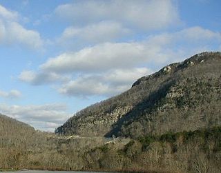
The Cumberland Gap is a pass in the eastern United States through the long ridge of the Cumberland Mountains, within the Appalachian Mountains and near the tripoint of Kentucky, Virginia, and Tennessee. At an elevation of 1,631 feet (497 m) above sea level, it is famous in American colonial history for its role as a key passageway through the lower central Appalachians.

The Tygart Valley River — also known as the Tygart River — is a principal tributary of the Monongahela River, approximately 135 miles (217 km) long, in east-central West Virginia in the United States. Via the Monongahela and Ohio rivers, it is part of the watershed of the Mississippi River, draining an area of 1,329 square miles (3,440 km2) in the Allegheny Mountains and the unglaciated portion of the Allegheny Plateau.
Circleville is an unincorporated community located in Pendleton County, West Virginia, United States. Circleville was originally named Zirkleville after John Zirkle, who ran a dry goods store in the town. The old Circleville School is listed on the National Register of Historic Places.
French Creek is an unincorporated community in Upshur County, West Virginia, United States.
Emmons is an unincorporated community located on the Big Coal River in Boone and Kanawha counties in the U.S. state of West Virginia. Jay Rockefeller's political affiliation with West Virginia began in 1964–1965 while he served as a VISTA volunteer in Emmons.

The Sycamore Shoals of the Watauga River, usually shortened to Sycamore Shoals, is a rocky stretch of river rapids along the Watauga River in Elizabethton, Tennessee. Archeological excavations have found Native Americans lived near the shoals since prehistoric times, and Cherokees gathered there. As Europeans began settling the Trans-Appalachian frontier, the shoals proved strategic militarily, as well as shaped the economies of Tennessee and Kentucky. Today, the shoals are protected as a National Historic Landmark and are maintained as part of Sycamore Shoals State Historic Park.

Nellis is an unincorporated community coal town in Boone County, West Virginia, United States on Brush Creek. The Nellis Historic District was listed on the National Register of Historic Places in 2000. Nellis was named by mine owners Matthew Slush and T.E.B. Siler after Frank E. Nellis, editor of the "Mount Clemens Independent" in Michigan.
Ice Mountain is a mountain ridge and algific talus slope that is part of a 149-acre (60 ha) preserve near the community of North River Mills in Hampshire County, West Virginia, United States. It was designated a National Natural Landmark in 2012.

Glady Fork is a 31.9-mile-long (51.3 km) river in the Allegheny Mountains of eastern West Virginia, USA. It is considered one of the five principal headwaters tributaries of the Cheat River — known as the Forks of Cheat.

Moccasin Gap, also known as Big Moccasin Gap, is a pass in Clinch Mountain, a long ridge within the Appalachian Mountains, at Gate City, Virginia. This gap has a long history as a passageway through the mountain. It was used by the Cherokee and Shawnee, and was the first gap through which the Daniel Boone Wilderness Road passed on its way to the better-known Cumberland Gap and Kentucky. Today it serves as a primary commercial route for industry, retail, and tourism businesses.

Snake Mountain is a mountain located along the border of North Carolina and Tennessee, east of the community of Zionville, in the southeastern United States. It is part of the Blue Ridge Mountains, and includes parts of Watauga County, North Carolina, and Johnson County, Tennessee. It has two peaks, the higher of which reaches an elevation of 5,564 feet (1,696 m). The lower peak, at 5,518 feet (1,682 m), is Johnson County's high point.
Morrisvale is an unincorporated community and coal town in Boone County, West Virginia, United States. Morrisvale is located on County Route 8 and Jack Smith Run, 7 miles (11 km) northwest of Madison.
References
- ↑ Development Concept Plan, Environmental Assessment: Glade Creek, New River Gorge National River, West Virginia. U.S. Department of the Interior, National Park Service. 1989.
- ↑ "Plumley Mountain". Geographic Names Information System . United States Geological Survey, United States Department of the Interior . Retrieved November 25, 2022.
- ↑ Boone County, West Virginia History. Boone County Genealogy Society. 1990.
- ↑ "Plumley Mountain". peakery.com. Retrieved November 2, 2022.
| | This article about a location in the Potomac Highlands of West Virginia is a stub. You can help Wikipedia by expanding it. |