
Saint-Eustache is an off-island suburb of Montreal, in western Quebec, Canada, west of Montreal on the north shore of the Rivière des Mille Îles. It is located 35 km (22 mi) northwest of Montreal.
Tadoussac is a village municipality in La Haute-Côte-Nord RCM, on the north shore of the maritime section of the estuary of St. Lawrence river, in Côte-Nord region, Quebec, Canada.
Baie-Comeau is a city in the Côte-Nord region of the province of Quebec, Canada. It is located on the shores of the St. Lawrence River, and is the seat of Manicouagan Regional County Municipality. It is near the mouth of the Manicouagan River, named after the adjacent Comeau Bay. It has a population of 20,687 in the 2021 Canadian census, and the census agglomeration population is 26,643.

Minganie is a regional county municipality bathes in the Gulf of St. Lawrence water's, in Côte-Nord region, Quebec, Canada, its territory includes Anticosti Island.

Baie-Trinité is part of the Manicouagan Regional County Municipality, in Côte-Nord region, Quebec province, Canada.

Château-Richer is a small town situated in the Capitale-Nationale region of Quebec, Canada. Located on the north shore of the Saint Lawrence River east of Quebec City, Château-Richer is the seat for the Côte-de-Beaupré Regional County Municipality.
Pohénégamook, Quebec is a Canadian town on the Canada–United States border in Quebec's Témiscouata Regional County Municipality.

Donnacona is an industrial town located about 40 kilometres (25 mi) west of Quebec City in Portneuf County, Quebec, Canada.

Pessamit, is a First Nations reserve and Innu community in the Canadian province of Quebec, located about 50 kilometres (31 mi) southwest from Baie-Comeau along the north shore of the Saint Lawrence River at the mouth of the Betsiamites River. It is across the river directly north of Rimouski, Quebec. It belongs to the Pessamit Innu Band.

Port-Cartier is a city in the Côte-Nord region of Quebec, Canada. It is located on the north shore of the St. Lawrence River at the mouth of the Aux-Rochers River, 63 kilometres (39 mi) southwest of Sept-Îles, Quebec.

Forestville is a town in the Côte-Nord region of Quebec, Canada. It is located on the north shore of the Saint Lawrence River along Route 138, approximately 103 kilometres (64 mi) southwest of Baie-Comeau. There is a vehicle and passenger ferry service from Forestville to Rimouski, on the south shore of the St. Lawrence that is over 50 kilometres (31 mi) wide at this point. The city operates the Forestville Airport.

Beaupré is a ville in the Canadian province of Quebec, located in La Côte-de-Beaupré Regional County Municipality. The town is along the Saint Lawrence River and Route 138 at the mouth of the Sainte-Anne-du-Nord River.

Dundee is a township municipality in Le Haut-Saint-Laurent Regional County Municipality in the Montérégie administrative region of Quebec, Canada. At the 2021 Canadian census, the population was 386. It is primarily an agricultural area consisting of dairy and grain farms.

Neuville is a village on the north shore of the Saint Lawrence River, just west of Quebec City, part of the Portneuf Regional County Municipality, Quebec, Canada. Founded in 1684, it remains picturesque.

Pointe-des-Cascades is a village municipality in Vaudreuil-Soulanges Regional County Municipality in the Montérégie region of Quebec, Canada. It is located on a spit of land where the St. Lawrence River flows into Lake Saint-Louis. The river has here a significant drop, forming several cascades which give the village its name. The islands of Île des Cascades and Île des Joybert are connected by a narrow causeway, but Île des Cascades and Pointe-des-Cascades are only connected artificially.

Chute-aux-Outardes is a village municipality in Quebec, Canada, at the mouth of the Outardes River. It is about 20 kilometres (12 mi) south-west of Baie-Comeau along Route 138.

Godbout is a village municipality in the Côte-Nord region of Quebec, Canada. It is located at the mouth of the Godbout River on the north shore of the Saint Lawrence River.
Pointe-Lebel is a village municipality in the Côte-Nord region of Quebec, Canada. Its territory makes up the western half of the Manicouagan Peninsula between the mouths of the Outardes and Manicouagan Rivers.

Ragueneau is a parish municipality located on Outardes Bay, on the north shore of the maritime estuary of the St. Lawrence River, in Côte-Nord region, Manicouagan RCM, in Quebec, Canada.

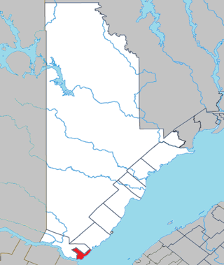
Rivière-aux-Outardes is an unorganized territory in the Côte-Nord region of Quebec, Canada. It makes up almost 95% of the Manicouagan Regional County Municipality.

