Political Divisions of Wayanad

Last updated

Map of Wayanad District Wayanad-district-map-en.svg
Map of Wayanad District

Wayanad District has four types of administrative hierarchies:

Contents

Administration of Wayanad


District Headquarters: Kalpetta. District Collector, District Police Chief and District Judge are based at Kalpetta.

Kalpetta Municipality in Kerala, India

Kalpetta is a town and a municipality in the Wayanad district, state of Kerala, India. Kalpetta is the headquarters of Wayanad district as well as the headquarters of Vythiri taluk. It is a bustling town surrounded by dense coffee and tea plantations and mountains. It lies on the Kozhikode-Mysore National Highway NH 766 at an altitude of about 780 m above sea level. Kalpetta is 72 km from Kozhikode and 140 km from Mysore.

Taluks of Wayanad

No. of Taluks: 3

Mananthavady City in Kerala, India

Mananthavady is a municipality and taluk in the Wayanad district of Kerala, India.The town is located on the banks of Mananthavady River, a tributary of the Kabini River. Mananthavady has been referred to as "Hosenkadi" in a dictum scribbled under a copper artefact found at the Ananthanathaswamy Temple at Varadoor. The dominant view on the etymology is that the word is derived from "Mane Eytha Vady ". This view is strengthened by the existence of a place called Ambukuthy, literally the location where the arrow pierced, on the outskirts of the town. This area was once ruled by the Pazhassi dynasty and the tomb of Pazhassi Raja is an important heritage site located in the heart of the town. Mananthavady was a major army camp for the British during their campaign against Pazhassi. One can still see the vestiges of the colonial period - canteen, club, barracks, rest house, cemetery - around Mananthavady. This is also the headquarters of the Adivasi Gothra Mahasabha. The District Hospital in Mananthavady is the only major treatment facility for the service of the tribal communities and other less privileged sections of Wayanad.

Assembly Seats

No. of state Assembly Legislators: 3 [1]

Wayanad Parliament Constituency

Wayanad Lok Sabha constituency is one of twenty Lok Sabha (lower house of the Parliament of India) constituencies in Kerala state in southern India. Wayanad is a newly created constituency consisting of seven assembly constituency segments.

Lok Sabha Lower house of the Parliament of India

The Lok Sabha or House of the People is the lower house of India's bicameral Parliament, with the upper house being the Rajya Sabha. Members of the Lok Sabha are elected by adult universal suffrage and a first-past-the-post system to represent their respective constituencies, and they hold their seats for five years or until the body is dissolved by the President on the advice of the council of ministers. The house meets in the Lok Sabha Chambers of the Sansad Bhavan in New Delhi.

Parliament of India National bicameral legislature of the Republic of India

The Parliament of India is the supreme legislative body of the Republic of India. It is a bicameral legislature composed of the President of India and the two houses: the Rajya Sabha and the Lok Sabha. The President in his role as head of legislature has full powers to summon and prorogue either house of Parliament or to dissolve Lok Sabha. The president can exercise these powers only upon the advice of the Prime Minister and his Union Council of Ministers.

Kerala State in southern India

Kerala is a state on the southwestern Malabar Coast of India. It was formed on 1 November 1956, following passage of the States Reorganisation Act, by combining Malayalam-speaking regions. Spread over 38,863 km2 (15,005 sq mi), Kerala is the twenty-second largest Indian state by area. It is bordered by Karnataka to the north and northeast, Tamil Nadu to the east and south, and the Lakshadweep Sea to the west. With 33,387,677 inhabitants as per the 2011 Census, Kerala is the thirteenth-largest Indian state by population. It is divided into 14 districts with the capital being Thiruvananthapuram. Malayalam is the most widely spoken language and is also the official language of the state.

Assembly segments

Wayanad Lok Sabha constituency is composed of the following assembly segments:

Thiruvambady Town in Kerala, India

Thiruvambady is a major hill town and a suburb in southeastern Kozhikode district in Kerala, India. Thiruvambady is a Panchayat headquarters, and a legislative assembly constituency, situated 35 kilometres (22 mi) from the district headquarters of Kozhikode.

Nilambur Town in Kerala, India

Nilambur is a municipality and a taluk in the Malappuram district of the Indian state of Kerala. It is located close to the Nilgiris range of the Western Ghats on the banks of the Chaliyar River. It is about 53.2 kilometers from Malappuram city and 26.8 kilometers from Manjeri on the Kozhikode–Gudalur road called CNG road.

Wandoor human settlement in India

Wandoor is a town in Malappuram district of Kerala, India at 11°11′44″N76°14′09″E. It is located 20 km away from Manjeri

Members of Parliament

M. I. Shanavas was an Indian politician. He was the working president of the Kerala Pradesh Congress Committee and a Member of Parliament of the 16th Lok Sabha of India.

Indian National Congress Major political party in India

The Indian National Congress(pronunciation ) is a political party in India with widespread roots. Founded in 1885, it was the first modern nationalist movement to emerge in the British Empire in Asia and Africa. From the late 19th century, and especially after 1920, under the leadership of Mahatma Gandhi, Congress became the principal leader of the Indian independence movement. Congress led India to independence from Great Britain, and powerfully influenced other anti-colonial nationalist movements in the British Empire.

Indian general election, 2014

Indian general election, 2014  : Wayanad
PartyCandidateVotes%±
AAP Adv. P P A Sageer10,6841.16
Trinamool Congress Satheesh Chandran741
BSP Vappan13170.14
BJP P R Rasmilnath80,7528.83%+4.98%
CPI Sathyan Mokeri356,16538.92%+7.69%
CPI(ML) Red Star Sam P Mathew1222
Independent P V Anwar37,1234.06
INC M I Shanavas 377,03541.21%-8.65%
SDPI Jaleel Neelambra14,3271.56
WPI Ramla Mampad12,6451.38
NOTA  10,7351.17% 
Margin of victory20,8702.28%-16.35%
Turnout 9,14,01573.28
INC hold Swing

See also

Coordinates: 11°38′02″N75°59′31″E / 11.634°N 75.992°E / 11.634; 75.992

Geographic coordinate system Coordinate system

A geographic coordinate system is a coordinate system that enables every location on Earth to be specified by a set of numbers, letters or symbols. The coordinates are often chosen such that one of the numbers represents a vertical position and two or three of the numbers represent a horizontal position; alternatively, a geographic position may be expressed in a combined three-dimensional Cartesian vector. A common choice of coordinates is latitude, longitude and elevation. To specify a location on a plane requires a map projection.

Related Research Articles

Wayanad district District in Kerala, India

Wayanad is an Indian district in the north-east of Kerala state with administrative headquarters at the municipality of Kalpetta. It is set high on the Western Ghats with altitudes ranging from 700 to 2100. The district was formed on 1 November 1980 as the 12th district in Kerala by carving out areas from Kozhikode and Kannur districts. About 885.92 sq.km of area of the district is under forest. Wayanad has three municipal towns—Kalpetta, Mananthavady and Sulthan Bathery. There are many indigenous tribals in this area.

Sultan Bathery City / Municipality in Kerala, India

Sulthan Bathery, formerly known as Sultan's Battery, is a town and municipality in Wayanad district of Kerala, India, near the borders with Tamil Nadu and Karnataka states. The largest city in Wayanad district, it is the headquarters of Sultan Bathery taluq. It is a quiet and peaceful town. The place came to be known by its new name after Mysore ruler Tipu Sultan invaded the region and used the Jain Temple located here as a battery. The pleasant weather in this beautiful town, coupled with excellent opportunities for shopping and spectacular historical sites makes the town of Sultan Bathery a popular tourist destination that is visited by tourists all year round. Located at an altitude of 1000 meters above the sea level, the town of Sultan Bathery boasts of a fantastic topography: majestic hills interspersed with valleys, cliffs and plains. Not only is Sultan Bathery now the largest town in the entire Wayanad district, but the place is also reputed for its tourism and commercial activities. The main attractions for the tourists are the pre-historic caves, jungle trails, sparkling streams and rivers and lush greenery of the undulating hills, along with many options to explore the city and its surroundings. Stopovers such as the Edakkal Caves, Chethalayam Falls, the Jain Temple, Muthanga Wildlife Sanctuary, Ambalavayal Heritage Museum and St. Mary's and Yakoob Church make this town a suitable choice for every kind of traveller, having something for everyone to see.

Nadapuram Town in Kerala, India

Nadapuram is a census town and a special grade Panchayath located in Kozhikode District of Kerala, coming under Nadapuram assembly constituency. It is in North Malabar region of Kerala, India; spread over an area of 20.44 km2.

Nadavayal is a town near Sultan Bathery in Wayanad district, Kerala, India. This small town hosted early migrants from Travancore (Thiruvithaamkoor).

Anchukunnu village in Kerala, India

Anjukunnu is a village in Wayanad district in the state of Kerala, India.

Kuppadi village in Kerala, India

Kuppadi is a village near Sultan Bathery in Wayanad district in the state of Kerala, India.The famous St Mary's College, Sulthan Bathery is situated in this village.

Noolpuzha village in Kerala, India

Noolpuzha is a village near Sulthan bathery in Wayanad district in the state of Kerala, India.

Panamaram Village in Kerala, India

Panamaram is a village in Wayanad district in the state of Kerala, India..

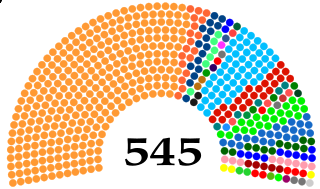
Wayanad is one of the 20 Lok Sabha (parliamentary) constituencies in the state of Kerala in southern India. The constituency was formed in 2009 and consists of seven assembly segments spread over three districts—Wayanad, Kozhikode and Malappuram.

Vythiri Taluk in Kerala, India

Vythiri is a small town and tourist destination located in the Wayanad district in the Indian state of Kerala. It is one of the three Taluks in the district with the other two being Mananthavady and Sulthan Bathery.

National Highway 766 (India) national highway in India

National Highway 766 is a National Highway in Southern India. NH 766 connects Kozhikode in Kerala with Kollegal in Karnataka via Mysore. Of the total distance of 272 km, 117 km is in Kerala and 155 is in Karnataka. At Kollegal, it joins National Highway 948, which connects Bengaluru and Coimbatore. The highway passes through dense forests of Western ghats of India. The NH-766 passes through Bandipur National Park and other reserve forests. The rapid rise in traffic of vehicles (Automobiles) in this highway has led to deaths of wild animals due to the speeding traffic, even though vehicles are not allowed from 9 P.M to 6 A.M in some stretches.

Meenangadi Town in Kerala, India

Meenangadi is an old town situated on the highway NH 766 between Kalpetta and Sulthan Bathery in Wayanad District, in Kerala, India. This place is one among the Provinces where the existence of Dolmens provide an historical evidence of earlier civilisation. Coffee bean, Black pepper, Ginger, Rice and Areca are the main crops of this area. Meenangadi is famous for its Fish Market,Cattle Market.The nearest railway station is at Kozhikode at 87 Km and airport is Kannur International Airport with 94 Km from Meenangadi. Meenangadi is surrounded by, Ambalavayal Panchayat, Kalpetta Taluk towards west, Gudalur Taluk towards East, Mananthavady Taluk towards west. Kalpetta, Sultan Bathery, Kozhikode are the nearby Cities and towns to Meenangadi.
Kerala's first carbon neutrality project launched in Meenangadi on June 2016. Upon achieving the goals of the project, Meenangadi will be the first village in India to go completely carbon neutral. Meenangadi has a population of 33450 According to 2011 Census with two Villages Purakkadi and (Part)Krishnagiri.

Transportation in Wayanad describes the transportation in Wayanad

The district capital of Wayanad is Kalpetta town. Kalpetta has very good road connectivity with the rest of Kerala and neighboring South Indian cities. National Highway 766 (India) NH766 connects Kalpetta with Kozhikode and Mysore. State Highways connect Kalpetta with Ooty in Tamil Nadu and Madikeri in Karnataka.

Kattikkulam(Kartikulam) is a small town near Mananthavady in Wayanad district, Kerala, India. It is also the headquarters of the Thirunelli gramapanchayath.

Educational Organizations are located mainly in Kalpetta and Sultan Battery.

Tourist attractions in Wayanad

The Wayanad District of Kerala, India has a wide variety of tourist attractions ranging from religious sites to natural, and historical sites. This district is divided into three towns, Kalpetta, Sultan Bathery and Mananthavady.

Krishnagiri Village Village in Kerala, India

Krishnagiri Village is a village in Wayanad District in the state of Kerala, India. It is in a rural area of Wayanad and one of the 15 villages in Sultan Bathery Tehsil.. It is about 16 km (9.9 mi) from Kalpetta and 9 km (5.6 mi) from Sultan Bathery in NH766

References

  1. "Assembly Constituencies – Corresponding Districts and Parliamentary Constituencies" (PDF). Kerala. Election Commission of India. Archived from the original (PDF) on 4 March 2009. Retrieved 18 October 2008.