Pontelandolfo

Last updated
Pontelandolfo
Comune di Pontelandolfo
Pontelandolfo - Scorcio del centro storico.jpg
Pontelandolfo-Stemma.gif
Location of Pontelandolfo
Pontelandolfo
Italy provincial location map 2016.svg
Red pog.svg
Pontelandolfo
Location of Pontelandolfo in Italy
Italy Campania location map.svg
Red pog.svg
Pontelandolfo
Pontelandolfo (Campania)
Coordinates: 41°17′N14°41′E / 41.283°N 14.683°E / 41.283; 14.683 Coordinates: 41°17′N14°41′E / 41.283°N 14.683°E / 41.283; 14.683
Country Italy
Region Campania
Province Benevento (BN)
Frazioni Acqua del Campo, Carluni, Ciccotto, Giallonardo, Grotte, Guitto, Lena, Malepara, Marziello, Pianelle, Pontelandolfo Scalo, Pontenuovo, Santa Caterina, Santillo, Sorgenza
Government
  MayorGianfranco Rinaldi
Area
[1]
  Total28 km2 (11 sq mi)
Elevation
510 m (1,670 ft)
Population
 (1 January 2022) [2]
  Total1,989
  Density71/km2 (180/sq mi)
Demonym(s) Pontelandolfesi
Time zone UTC+1 (CET)
  Summer (DST) UTC+2 (CEST)
Postal code
82027
Dialing code 0824
ISTAT code 062054
Patron saint Saint Donato and Saint Anthony [3]
Saint day7 August and 13 June
Website Official website

Pontelandolfo is an Italian town and comune in the Sannio Hills in the province of Benevento, approximately halfway between Naples and Campobasso.

Contents

Geography

Pontelandolfo is located on a mountainous area of Italy. The area that surrounds Pontelandolfo has a wide range of altitudes (400-1,017 meters), with the center of population situated at 525 meters.

There are three prominent mountains that surround Pontelandolfo. These include Mount Calvello, which has an altitude of 1,017 meters, Toppo Mangialardo (917 m) and Mount Forgioso (850 m).

History

The name of the village comes from the legendary Pontis Landulphi, or the Bridge of Landolfo , named after a soldier who died defending the bridge against the Romans while the villagers fled to safety, an event memorialized in the village's crest. The bridge is believed to have spanned the Alenta Creek, whose source is the Calore Irpino. [4]

According to local ancient folklore, the regional surname Guerrera derived from the Latin spelling Gverrera meaning warrior or man of war, is said to have origins dating back to the soldier who died defending the bridge against the Romans. The Guerrera clan for centuries inhabited the fertile lands south of the Alenta Creek stretching between San Lupo and Pontelandolfo centred in and around the current village of Giallonardo.

Pontelandolfo is mostly remembered as the location, along with Casalduni, of a massacre of largely civilian population by the Piedmontese occupation troops in 1861.

Memorial remembering the Pontelandoldo and Casalduni massacre (1861) Casalduni - Monumento in memoria delle vittime del massacro di Pontelandolfo e Casalduni (1861).png
Memorial remembering the Pontelandoldo and Casalduni massacre (1861)

Many villagers emigrated to the United States, with a large community settling in and around Waterbury, Connecticut, where they founded the Pontelandolfo Community Club. A large number also moved to Canada, specifically to the city of Montreal. A significant number also emigrated to Australia in the period post World War 2 to the early 1970s and settled predominantly on Sydney's North Shore and Eastern Suburbs area, and whose family surnames include: Guerrera; Orsini; Mucciacciaro; Rubbo; and Mancini. A small number also settled in and around Melbourne. The early Australian emigrants worked in the Queensland sugar cane fields before moving to Sydney where they settled and were later joined by their extended families.[ citation needed ]

Main sights

Economy

Much of the surrounding area of Pontelandolfo (14.91 km2) is used for agriculture thanks to the fertility of the ground, which was already well known by the ancient Greeks. The primary use of the land is for olive-tree orchards, pastures and for the culture of cereals.

Twin towns

Pontelandolfo is twinned with:

Related Research Articles

Province of Benevento Province of Italy

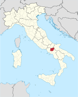
The Province of Benevento is a province in the Campania region of Italy. Its capital is the city of Benevento.

San Lupo is the name of a hill town and comune in the province of Benevento, in the Campania region of southern Italy. It is a member of the Titerno "Local Action Group".

Mirabello Sannitico Comune in Molise, Italy

Mirabello Sannitico is a small town in the province of Campobasso, Molise, southern Italy. The population is about 2,100 inhabitants. It has anagrarian-based culture and history, dating back to at least the 12th century. Nearby towns include Campobasso to the northwest and Vinchiaturo to the southwest. The Tappino River flows on either side of the town on the north and south.

Cantalupo nel Sannio is a town and comune in the province of Isernia, in the Molise region of southern Italy.

Apice Comune in Campania, Italy

Apice is a comune (municipality) in the Province of Benevento in the Italian region Campania, located about 70 km northeast of Naples and about 13 km east of Benevento.

Apollosa is a comune (municipality) in the Province of Benevento in the Italian region Campania, located about 50 km northeast of Naples and about 8 km southwest of Benevento.

Calvi, Campania Comune in Campania, Italy


Calvi is a comune (municipality) in the Province of Benevento in the southern Italian region Campania, located about 60 km northeast of Naples and about 10 km southeast of Benevento. It also belongs to the Samnium historical region. Its territory has an altitude of between 169m and 388m above sea level.

Campolattaro Comune in Campania, Italy

Campolattaro is a comune (municipality) of 995 inhabitants in the Province of Benevento in the Italian region of Campania, located about 60 kilometres (37 mi) northeast of Naples and about 20 kilometers north of Benevento, its Provincial Capital. Bordering the municipalities of Casalduni, Circello, Fragneto l'Abate, Fragneto Monforte, Morcone, and Pontelandolfo, Campolattaro is part of the historic region of Samnium.

Castelpagano is a comune (municipality) in the Province of Benevento in the Italian region Campania, located about 80 km northeast of Naples and about 30 km north of Benevento.

Castelvetere in Val Fortore Comune in Campania, Italy

Castelvetere in Val Fortore is a comune (municipality) in the Province of Benevento in the Italian region Campania, located about 90 km northeast of Naples and about 35 km northeast of Benevento in the upper valley of the Fortore River (Sannio).

Cerreto Sannita Comune in Campania, Italy

Cerreto Sannita is a comune (municipality) in the Province of Benevento in the Italian region Campania, located about 60 km northeast of Naples and about 25 km northwest of Benevento.

Fragneto Monforte Comune in Campania, Italy

Fragneto Monforte is a comune (municipality) in the Province of Benevento in the Italian region Campania.

Morcone Comune in Campania, Italy


Morcone is a comune (municipality) in the Province of Benevento in the Italian region Campania, located about 70 km northeast of Naples and about 25 km northwest of Benevento. The villages (Contrade) of Morcone include: Canepino, Cuffiano, Coste, Torre, Fuschi, Piana.

Pietraroja Comune in Campania, Italy

Pietraroja is a mountain comune (municipality) in the province of Benevento in Campania, southern Italy. It is approximately 50 km by car from Benevento, in direction north-west, 83 km from Naples in direction north-east and approximately 223 km from Rome in direction south-east.

San Giorgio del Sannio is a comune (municipality) in the Province of Benevento in the Italian region Campania, located about 60 km northeast of Naples and about 9 km southeast of Benevento. As of 31 December 2004, it had a population of 9,785 and an area of 22.3 km2.

San Leucio del Sannio is a comune (municipality) in the Province of Benevento in the Italian region Campania, located about 50 km northeast of Naples and about 6 km south of Benevento. As of 31 December 2004, it had a population of 3,269 and an area of 10.0 km2.

SantAngelo a Cupolo Comune in Campania, Italy

Sant'Angelo a Cupolo is a comune (municipality) in the Province of Benevento in the Italian region Campania, located about 50 km northeast of Naples and about 8 km south of Benevento. As of 31 December 2004, it had a population of 4,262 and an area of 10.9 km2.

San Giovanni in Galdo Comune in Molise, Italy

San Giovanni in Galdo is a comune (municipality) in the Province of Campobasso in the Italian region of Molise, located about 7 kilometres (4 mi) east of Campobasso.

San Massimo is a comune (municipality) in the Province of Campobasso in the Italian region Molise, located about 25 kilometres (16 mi) southwest of Campobasso, comprising 27.6 square kilometres (10.7 sq mi).

Tiana, Tìana in Sardinian language, is a comune (municipality) in the Province of Nuoro in the Italian region Sardinia, located in a valley on the slopes of Gennargentu mountain in the Ollolai Barbagia, about 150 kilometres (93 mi) north of Cagliari and about 50 kilometres (31 mi) southwest of Nuoro. As of 31 December 2004, it had a population of 547 and an area of 19.3 square kilometres (7.5 sq mi).

References

  1. "Superficie di Comuni Province e Regioni italiane al 9 ottobre 2011". Italian National Institute of Statistics. Retrieved 16 March 2019.
  2. "Resident population". Istat. 1 January 2022. Retrieved 23 April 2022.
  3. "Comune di Pontelandolfo". Comuni di Italia. Retrieved 23 April 2022.
  4. (in Italian) A. Iamalio, P. Federico, G. Ardia: La Regina del Sannio. Naples, 1918, pg. 226.