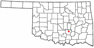
Pontotoc County is a county in the south central part of Oklahoma. As of the 2020 census, the population was 38,065. Its county seat is Ada. The county was created at statehood from part of the Chickasaw Nation in Indian Territory. It was named for a historic Chickasaw tribal area in Mississippi. According to the Encyclopedia of Oklahoma History and Culture, Pontotoc is usually translated "cattail prairie" or "land of hanging grapes."

Murray County is a county located in the southern part of the U.S. state of Oklahoma. As of the 2020 census, the population was 13,904. The county seat is Sulphur. The county was named for William H. Murray, a member and president of the Oklahoma Constitutional Convention and later a Governor of Oklahoma.

McClain County is a county located in south central Oklahoma. As of the 2020 census, the population was 41,662. Its county seat is Purcell. The county was named for Charles M. McClain, an Oklahoma constitutional convention attendee.

Johnston County is a county located in the U.S. state of Oklahoma. As of the 2020 census, the population was 10,272. Its county seat is Tishomingo. It was established at statehood on November 16, 1907, and named for Douglas H. Johnston, a governor of the Chickasaw Nation.
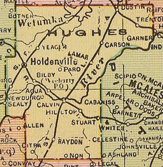
Hughes County is a county located in south central U.S. state of Oklahoma. As of the 2020 census, the population was 13,367. Its county seat is Holdenville. The county was named for W. C. Hughes, an Oklahoma City lawyer who was a member of the Oklahoma Constitutional Convention.

Garvin County is a county in south-central Oklahoma, United States. As of the 2020 census, the population was 25,656. Its county seat is Pauls Valley. In 1906, delegates to Constitution Convention formed Garvin County from part of the Chickasaw Nation, Indian Territory. The county was named for Samuel J. Garvin, a local Chickasaw rancher, merchant and banker. Its economy is largely based on farming, ranching and oil production.

Coal County is a county located in the U.S. state of Oklahoma. As of the 2020 census, the population was 5,266. Its county seat is Coalgate.

Union County is a county located in the U.S. state of Mississippi. It was formed in 1870 from Tippah and Pontotoc counties, and in 1874 a portion of Lee County was added. As of the 2020 census, the population was 27,777. Its county seat is New Albany. According to most sources, the county received its name by being a union of pieces of several large counties, like other Union counties in other states. However, other sources say that the name was meant to mark the re-union of Mississippi and the other Confederate states after the Civil War.
Pontotoc County is a county located in the U.S. state of Mississippi. As of the 2020 census, the population was 31,184. Its county seat is Pontotoc. It was created on February 9, 1836, from lands ceded to the United States under the Chickasaw Cession. Pontotoc is a Chickasaw word meaning "land of hanging grapes". The original Natchez Trace and the current-day Natchez Trace Parkway both pass through the southeast corner of Pontotoc County.
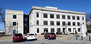
Ada is a city in and the county seat of Pontotoc County, Oklahoma, United States. The population was 16,481 at the 2020 United States Census. The city was named for Ada Reed, the daughter of an early settler, and was incorporated in 1901. Ada is home to East Central University, and is the capital of the Chickasaw Nation. Ada is an Oklahoma Main Street City, an Oklahoma Certified City, and a Tree City USA member.

Byng is a town in Pontotoc County, Oklahoma, United States. The population was 1,175 at the 2010 census.

Fitzhugh is a town in Pontotoc County, Oklahoma, United States. The population was 204 at the 2000 census.

Francis is a town in Pontotoc County, Oklahoma, United States. The population was 332 at the 2000 census.

Roff is a town in Pontotoc County, Oklahoma, United States. The population was 725 at the 2010 census.

Stonewall is a town in Pontotoc County, Oklahoma, United States. Named for Confederate General Stonewall Jackson, the settlement's post office was established in December 1874.
Allen is a town in Hughes and Pontotoc counties in the U.S. state of Oklahoma. The population was 805 at the 2020 census.
Fittstown is an unincorporated community in Pontotoc County, Oklahoma, United States. Fittstown is located on U.S. Route 377, 11 miles (18 km) south-southeast of Ada. Fittstown has a post office with ZIP code 74842.
Vanoss is an unincorporated community in Pontotoc County, Oklahoma, United States. The community is located 10 miles west of Ada. The town was originally named Midland and was located a few miles away from its present location. When the Oklahoma Central Railroad was built, the townspeople moved the town so it would be next to the railroad, and they changed its name to Vanoss in honor of Salomon Frederik van Oss, who was a Dutch director and financier of the Oklahoma Central Railroad. Though little remains of the community, Vanoss Public Schools, including an elementary school, a middle school, and Vanoss High School, continue to serve the surrounding area.
Latta is an unincorporated community and census-designated place in Pontotoc County, Oklahoma, United States. Its population was 1,172 as of 2016. Oklahoma State Highway 1 passes through the community.
Pickett is an unincorporated community and census-designated place (CDP) in Pontotoc County, Oklahoma, United States. It was first listed as a CDP prior to the 2020 census.


