
The Potomac River is a major river in the Mid-Atlantic region of the United States that flows from the Potomac Highlands in West Virginia to the Chesapeake Bay in Maryland. It is 405 miles (652 km) long, with a drainage area of 14,700 square miles (38,000 km2), and is the fourth-largest river along the East Coast of the United States. More than 6 million people live within its watershed.

Paw Paw is a town in Morgan County, West Virginia, United States. The population was 410 at the 2020 census. The town is known for the nearby Paw Paw Tunnel. Paw Paw was incorporated by the Circuit Court of Morgan County on April 8, 1891, and named after pawpaw, a wild fruit that grows in abundance throughout this region. Paw Paw is the westernmost incorporated community in Morgan County, and the Hagerstown-Martinsburg, MD-WV Metropolitan Statistical Area.

The Chesapeake and Ohio Canal, abbreviated as the C&O Canal and occasionally called the Grand Old Ditch, operated from 1831 until 1924 along the Potomac River between Washington, D.C. and Cumberland, Maryland. It replaced the Potomac Canal, which shut down completely in 1828, and could operate during months in which the water level was too low for the former canal. The canal's principal cargo was coal from the Allegheny Mountains.

The James River is a river in Virginia that begins in the Appalachian Mountains and flows from the confluence of the Cowpasture and Jackson Rivers in Botetourt County 348 miles (560 km) to the Chesapeake Bay. The river length extends to 444 miles (715 km) if the Jackson River is included, the longer of its two headwaters. It is the longest river in Virginia. Jamestown and Williamsburg, Virginia's first colonial capitals, and Richmond, Virginia's current capital, lie on the James River.
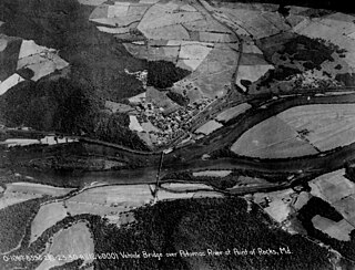
Point of Rocks is an unincorporated community and census-designated place (CDP) in Frederick County, Maryland. As of the 2010 census, it had a population of 1,466.

The Paw Paw Tunnel is a 3,118-foot-long (950 m) canal tunnel on the Chesapeake and Ohio Canal (C&O) in Allegany County, Maryland. Located near Paw Paw, West Virginia, it was built to bypass the Paw Paw Bends, a six-mile (9.7 km) stretch of the Potomac River containing five horseshoe-shaped bends. The town, the bends, and the tunnel take their name from the pawpaw trees that grow prolifically along nearby ridges.

The Chesapeake and Ohio Canal National Historical Park is located in the District of Columbia and the state of Maryland. The park was established in 1961 as a National Monument by President Dwight D. Eisenhower to preserve the neglected remains of the Chesapeake and Ohio Canal and many of its original structures.

The Patowmack Canal, sometimes called the Potomac Canal, is a series of five inoperative canals located in Maryland and Virginia, United States, that was designed to bypass rapids in the Potomac River upstream of the present Washington, D.C., area. The most well known of them is the Great Falls skirting canal, whose remains are managed by the National Park Service since it is within Great Falls Park, an integral part of the George Washington Memorial Parkway.

The James River and Kanawha Canal was a partially built canal in Virginia intended to facilitate shipments of passengers and freight by water between the western counties of Virginia and the coast. Ultimately its towpath became the roadbed for a rail line following the same course.
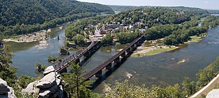
Harpers Ferry National Historical Park, originally Harpers Ferry National Monument, is located at the confluence of the Potomac and Shenandoah rivers in and around Harpers Ferry, West Virginia. The park includes the historic center of Harpers Ferry, notable as a key 19th-century industrial area and as the scene of John Brown's failed abolitionist uprising. It contains the most visited historic site in the state of West Virginia, John Brown's Fort.

The Tidewater Lock is a dam in Washington, D.C. to the west of the mouth of Rock Creek at the Potomac River, on the east side of Georgetown. Built to connect the Chesapeake and Ohio Canal, opened in 1831, with the Potomac, it was a busy maritime intersection during several decades of the canal's heyday. C&O documents refer to it variously as Lock 0 and Tide Lock A.

The Locks on the Chesapeake and Ohio Canal, located in Maryland, West Virginia, and Washington, D.C. of the United States, were of three types: lift locks; river locks; and guard, or inlet, locks.

Milner Dam is a rockfill dam near Burley in south central Idaho. It impounds the Snake River in a reservoir named Milner Lake. The dam spans the river across two islands, with three embankments.
Edward Colston was a Virginia lawyer, slaveholder and Federalist politician who served in the Virginia House of Delegates and United States House of Representatives.

The Harpers Ferry Historic District comprises about one hundred historic structures in Harpers Ferry, West Virginia. The historic district includes the portions of the central town not included in Harpers Ferry National Historical Park, including large numbers of early 19th-century houses built by the United States Government for the workers at the Harpers Ferry Armory. Significant buildings and sites include the site of the Armory, the U.S Armory Potomac Canal, the Harpers Ferry Train Station, and Shenandoah Street, Potomac Street, and High or Washington Street. The National Historic Park essentially comprises the lower, flood-prone areas of the town, while the Historic District comprises the upper town.

Power Plant and Dam No. 4 is a historic hydroelectric power generation station on the Potomac River, located near Shepherdstown on the county line between Berkeley and Jefferson County, West Virginia. The power plant is a tall one-story, limestone building on a high stone foundation. It is five bays long and has a gable roof. Dam 4 uses horizontal shaft turbines connected by rope drives to horizontal shaft generators. This plant is probably the last commercially operated rope-driven hydroelectric plant in the United States. The building is built into a hillside, so the main floor is the top floor. The power plant was originally built by the Martinsburg Electric Company.
The Chesapeake and Ohio Canal (C&O) used 11 navigable aqueducts to carry the canal over rivers and streams that were too wide for a culvert to contain. Aqueducts, like locks and other masonry structures, were called "works of art" by the canal board of directors.
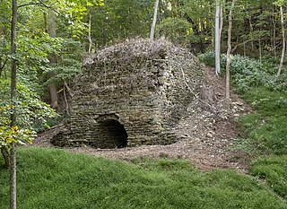
The Potomac Mills was a mill complex located along the Potomac River roughly .5 miles (0.80 km) downriver of Shepherdstown. Built in 1826, the complex was originally used as a gristmill. In 1829, the mill began producing cement for the Chesapeake and Ohio Canal's construction. The factory continued to produce cement after the canal opened, and it shipped its product along the canal to other cities. Flooding and drought conditions in the 1880s led the mill to reduce its operations, and by 1901 the mill closed permanently.
Seneca Dam was the last in a series of dams proposed on the Potomac River in the area of the Great Falls of the Potomac. Apart from small-scale dams intended to divert water for municipal use in the District of Columbia and into the Chesapeake and Ohio Canal, no version of any scheme was ever built. In most cases the proposed reservoir would have extended upriver to Harpers Ferry, West Virginia. The project was part of a program of as many as sixteen major dams in the Potomac watershed, most of which were never built.

Violette's Lock is part of the 184.5-mile (296.9 km) Chesapeake and Ohio Canal that operated in the United States along the Potomac River from the 1830s through 1923. It is located at towpath mile-marker 22.1, in Montgomery County, Maryland. The name Violette comes from Alfred L. "Ap" Violette and his wife Kate, who were lock keepers from the beginning of the 20th century through the permanent closure of the canal in 1924.


