Punta Cornour

Last updated
Punta Cornour
Punta Cournour
Punta Cornour.JPG
Late autumn view
Highest point
Elevation 2,868 m (9,409 ft) [1]
Prominence 418 m (1,371 ft) [2] [3]
Listing Alpine mountains 2500-2999 m
Coordinates 44°51′01″N7°05′33″E / 44.8501817°N 7.0924816°E / 44.8501817; 7.0924816 Coordinates: 44°51′01″N7°05′33″E / 44.8501817°N 7.0924816°E / 44.8501817; 7.0924816
Geography
Alps location map.png
Red triangle with thick white border.svg
Punta Cornour
Location in the Alps
Location Piemonte, Italy
Parent range Cottian Alps
Climbing
First ascent 1836, Captain Cossato of the Royal Sardinian Army [4]
Easiest route Hike with some scabbling

The Punta Cornour is a 2,868 [4] metres high mountain on the Italian side of the Cottian Alps.

Contents

Toponymy

View from the Tredici Laghi plateau. Altopiano dei Tredici Laghi - lago della Drajo.jpg
View from the Tredici Laghi plateau.

The mountain is also named Punta Cournour. While Punta Cornour appears in most of the available maps (i.e. the 1:50.000 scale IGC map Valli di Susa Chisone e Germanasca, based on the IGM official Italian 1:25.000 cartography ), Punta Cournour is reported by some older sources as, for instance, the Encyclopædia Britannica in its 1911 edition. [5]

Geography

The Punta Cornour is located on the water divide between val Germanasca (North) and val Pellice. It consists in a prominent peak clearly distinguishable also from the Po plain. The main ridge runs from SW to NE; from the summit branches out another ridge heading South. The summit of the mountain is the tripoint where the comune of Prali (Val Germanasca) meets Bobbio Pellice and Villar Pellice (both in Val Pellice). [6] The SE slopes, belonging to the comune of Villar Pellice, are made of steep rock cliffs, while the other faces have gentler slopes with a lot of blocks.

On the summit a small metallic pillar points out a trigpoint named 067905 Punta Cornour, whish belonging to the primary IGM network. [7]

SOIUSA classification

According to SOIUSA (International Standardized Mountain Subdivision of the Alps) the mountain can be classified in the following way: [8]

Geology

From a geological point of view the mountain belongs to the Dora-Maira massif series, and is mainly composed of gneiss and mica-schists, with lenses of Augen gneiss, dating back to the pre-Triassic era. [9]

Access to the summit

View from Grand Truc. Punta Cornour 001.JPG
View from Grand Truc.

The normal route follows the NE ridge of the mountain. [4] An access itinerary starts from Ghigo (comune of Prali) close to the valley station of the cable car Seggiovia dei 13 Laghi, which can be used in order to shorten the walk. [10]

Related Research Articles

Mont dAmbin Mountain in the Cottian Alps on the French-Italian border

Mont d'Ambin or Rocca d'Ambin is a mountain on the border of Savoie, France and of the Province of Turin, Italy. It lies in the Ambin group of the Cottian Alps. On the Italian side, it commands the view of the Val di Susa. It has an elevation of 3,378 metres (11,083 ft) above sea level. The Mont d'Ambin base tunnel of the Lyon–Turin rail link is being dug at its base.

Pointe de Paumont

Pointe de Paumont or Cima del Vallone is a mountain of Savoie, France and of the Province of Turin, Italy. It lies in the Cottian Alps range. It has an elevation of 3,171 metres above sea level.

Punta Bagnà

Punta Bagnà or Cime du Grand Vallon is a mountain of Savoie, France and of the Province of Turin, Italy. It lies in the Cottian Alps range. It has an elevation of 3,129 metres above sea level.

Punta Sommeiller

Punta Sommeiller or Pointe Sommeiller is a mountain of the Province of Turin, Italy and of Savoie, France. It lies in the Cottian Alps range. It has an elevation of 3,333 metres (10,935 ft) above sea level.

Rognosa dEtiache

Rognosa d'Etiache or Rognosa d'Étache is a mountain in the Cottian Alps on the border of Turin, Italy, and Savoie, France. It has an elevation of 3,382 metres above sea level.

Ambin group Sub-range of the Cottian Alps on the French-Italian border

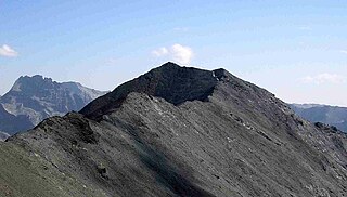
The Ambin group is a sub-range of the Cottian Alps located on the French-Italian border.

Monte Orsiera

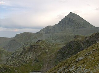
Monte Orsiera is a mountain in the Cottian Alps belonging to the Province of Turin (Italy).

Colle della Croce Pedestrian pass of the Cottian Alps

The Colle della Croce (Italian) or Col Lacroix is a pedestrian pass of the Cottian Alps.

Punta Sulè Mountain in Italy

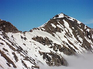
Punta Sulè is a 3,384 m a.s.l.mountain of the Graian Alps, located in Italy.

Bric Ghinivert Mountain in Italy

Bric Ghinivert or Eiminàl is a mountain of the Cottian Alps located in Italy.

Monte Politri Mountain in Italy

Monte Politri or Bric Rosso is a 3,026 m a.s.l. mountain of the Cottian Alps, located in Italy.

Monte Albergian Mountain in Italy

Monte Albergian is a 3,041 m a.s.l. mountain of the Cottian Alps, located in Italy. A battalion of 3rd Alpini Regiment, which during World War I earned a Silver Medal of Military Valor, was named after Monte Albergian.

Punta Tempesta Mountain in Italy

Punta Tempesta is a 2,679 m a.s.l. mountain of the Cottian Alps, located in Italy.

Punta Merciantaira

The Punta Merciantaira or Grand Glaiza is a 3,293 metres high mountain of the Cottian Alps.

Viso Mozzo Mountain in Italy

The Viso Mozzo is a 3,019 metres high mountain on the Italian side of the Cottian Alps.

Grand Queyron

The Gran Queyron or Grand Queyron is a 3,060 metres high mountain of the Cottian Alps.

Punta Nera

The Punta Nera is a mountain of Savoie (France) and of the Province of Turin (Italy). It lies in the Cottian Alps range. It has an elevation of 3,047 metres above sea level.

Pointe Rochers Charniers Mountain in France

The Pointe Rochers Charniers is a mountain of the Cottian Alps at an elevation of 3,063 metres above sea level, located in France.

Punta Lunella Mountain in Italy

The Punta Lunella is a mountain of the Graian Alps, with an elevation of 2,772 m.

Cima Ciantiplagna Mountain in Italy

The Cima Ciantiplagna is a mountain in the Cottian Alps belonging to the Province of Turin (Italy).

References

  1. Istituto Geografico Centrale, Carta dei sentieri 1:50.000 scale nr. 6, Monviso
  2. Key col: Passo di Brard, 2,450 m, see Peakbagger entry
  3. Punta Cornour, Italy at Peakbagger.com
  4. 1 2 3 Ferreri, Eugenio (1982). Alpi Cozie centrali. Guida dei Monti d'Italia (in Italian). Milano: CAI / TCI. pp. 171–173.
  5. Chisholm, Hugh, ed. (1911). "Alps"  . Encyclopædia Britannica . Vol. 1 (11th ed.). Cambridge University Press. p. 741.
  6. "IGM 1:25.000 maps". Istituto Geografico Militare . Retrieved 2020-02-23.
  7. Divisione geodetica. "067905 PUNTA CORNOUR". Istituto Geografico Militare . Retrieved 2020-02-22.
  8. Marazzi, Sergio (2005). Atlante Orografico delle Alpi. SOIUSA (in Italian). Priuli & Verlucca. p. 88. ISBN   978-88-8068-273-8.
  9. Carta Geologica d'Italia scala 1:100.000 - foglio 67 - Pinerolo. ISPRA (Istituto Superiore per la Protezione e la Ricerca Ambientale). Servizio Geologico d'Italia. Retrieved 2020-02-22.
  10. "Cornour (Punta) da Ghigo di Prali, per la cresta NE" (in Italian). Retrieved 2020-02-23.

Maps