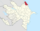
Qarğalıq, Khachmaz

Last updated

Coordinates: 41°27′20″N48°58′20″E / 41.45556°N 48.97222°E / 41.45556; 48.97222

Geographic coordinate system Coordinate system

A geographic coordinate system is a coordinate system that enables every location on Earth to be specified by a set of numbers, letters or symbols. The coordinates are often chosen such that one of the numbers represents a vertical position and two or three of the numbers represent a horizontal position; alternatively, a geographic position may be expressed in a combined three-dimensional Cartesian vector. A common choice of coordinates is latitude, longitude and elevation. To specify a location on a plane requires a map projection.

Qarğalıq
Azerbaijan adm location map.svg
Red pog.svg
Qarğalıq
Coordinates: 41°27′20″N48°58′20″E / 41.45556°N 48.97222°E / 41.45556; 48.97222
CountryFlag of Azerbaijan.svg  Azerbaijan
Rayon Khachmaz
Municipality İlxıçı
Time zone AZT (UTC+4)
  Summer (DST) AZT (UTC+5)

Qarğalıq (also, Kargalyk and Il’kychy-Gasanefendi) is a village in the Khachmaz Rayon of Azerbaijan. The village forms part of the municipality of İlxıçı. [1]

Azerbaijan Country in the South Caucasus

Azerbaijan, officially the Republic of Azerbaijan, is a country in the South Caucasus region of Eurasia at the crossroads of Eastern Europe and Western Asia. It is bounded by the Caspian Sea to the east, Russia to the north, Georgia to the northwest, Armenia to the west and Iran to the south. The exclave of Nakhchivan is bounded by Armenia to the north and east, Iran to the south and west, and has an 11 km long border with Turkey in the northwest.

İlxıçı, Khachmaz Municipality in Khachmaz, Azerbaijan

İlxıçı is a village and municipality in the Khachmaz Rayon of Azerbaijan. It has a population of 617. The municipality consists of the villages of İlxıçı and Qarğalıq.

Related Research Articles

Sumağavaqazma Place in Davachi, Azerbaijan

Sumağavaqazma is a village in the Davachi Rayon of Azerbaijan. The village forms part of the municipality of Pirəbədil.

Xallanlı Place in Kalbajar

Xallanlı is a village in the Kalbajar Rayon of Azerbaijan.

Qarğalıq, Masally Municipality in Masally, Azerbaijan

Qarğalıq is a village and municipality in the Masally Rayon of Azerbaijan. It has a population of 1,516.

Çətgün Place in Qusar, Azerbaijan

Çətgün is a village in the Qusar Rayon of Azerbaijan. The village forms part of the municipality of Kuzun.

Novonikolayevka, Azerbaijan Place in Quba, Azerbaijan

Novonikolayevka is a village in the Quba Rayon of Azerbaijan. The village forms part of the municipality of Hacıhüseynli.

Rük Place in Quba, Azerbaijan

Rük is a village in the Quba Rayon of Azerbaijan. The village forms part of the municipality of Söhüb.

Zeyid Place in Quba, Azerbaijan

Zeyid is a village in the Quba Rayon of Azerbaijan. The village forms part of the municipality of Buduq.

Ağarəhimoba Place in Khachmaz, Azerbaijan

Ağarəhimoba is a village in the Khachmaz Rayon of Azerbaijan. The village forms part of the municipality of Qadaşoba.

Hacıməmmədoba Place in Khachmaz, Azerbaijan

Hacıməmmədoba is a village in the Khachmaz Rayon of Azerbaijan. The village forms part of the municipality of Pirquluoba.

Kapanly Place in Davachi, Azerbaijan

Kapanly is a village in the Davachi Rayon of Azerbaijan.

Adur, Azerbaijan Place in Quba, Azerbaijan

Adur is a village in the Quba Rayon of Azerbaijan. The village forms part of the municipality of Qarxun.

Şimal Place in Khachmaz, Azerbaijan

Şimal is a village in the Khachmaz Rayon of Azerbaijan. The village forms part of the municipality of Nabran.

Urmis Place in Nakhchivan, Azerbaijan

Urmis is a village in the Nakhchivan Autonomous Republic of Azerbaijan.

Müşfiq Place in Khachmaz, Azerbaijan

Müşfiq is a village in the municipality of Müşkür in the Khachmaz Rayon of Azerbaijan.

Paşaoba is a village and municipality in the Quba Rayon of Azerbaijan. It has a population of 993.

Xaspolad is a village in the municipality of Zərqava in the Quba Rayon of Azerbaijan.

Nowy Folwark, Pomeranian Voivodeship Village in Pomeranian, Poland

Nowy Folwark is a village in the administrative district of Gmina Stary Dzierzgoń, within Sztum County, Pomeranian Voivodeship, in northern Poland. It lies approximately 5 kilometres (3 mi) north-east of Stary Dzierzgoń, 29 km (18 mi) east of Sztum, and 78 km (48 mi) south-east of the regional capital Gdańsk.

Männiku is a village in Märjamaa Parish, Rapla County in western Estonia.

Ujan-e Gharbi Rural District is a rural district (dehestan) in the Central District of Bostanabad County, East Azerbaijan Province, Iran. At the 2006 census, its population was 10,458, in 1,940 families. The rural district has 25 villages.

References

  1. "Belediyye Informasiya Sistemi" (in Azerbaijani). Archived from the original on September 24, 2008.