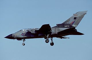
Royal Air Force Cottesmore or more simply RAF Cottesmore is a former Royal Air Force station in Rutland, England, situated between Cottesmore and Market Overton. On 15 December 2009, Defence Secretary Bob Ainsworth announced that the station would close in 2013 as part of defence spending cuts, along with the retirement of the Harrier GR9 and the disbandment of Joint Force Harrier. The formal closing ceremony took place on 31 March 2011, and the airfield became a satellite of RAF Wittering until March 2012.

Royal Air Force Aldermaston, or more simply RAF Aldermaston, is a former Royal Air Force station located 8 miles (13 km) east of Newbury, Berkshire and 9.8 miles (15.8 km) southwest of Reading, Berkshire, England.
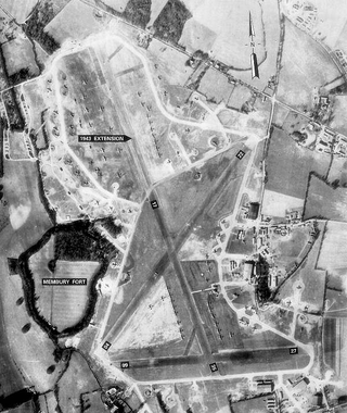
Royal Air Force Membury or more simply RAF Membury is a former Royal Air Force station built in the civil parish of Lambourn in Berkshire, England, approximately 4.6 miles (7.4 km) north-northwest of Hungerford. The airfield was opened on the site of a civil airfield in August 1942, and closed in October 1946.
Royal Air Force Foulsham, more commonly known as RAF Foulsham is a former Royal Air Force station, a military airfield, located 15 miles North-West of Norwich, in the English county of Norfolk, East Anglia, from 1942 to 1945.
Royal Air Force East Wretham or more simply RAF East Wretham is a former Royal Air Force station located 6 miles (9.7 km) northeast of Thetford, Norfolk, England.

Royal Air Force Great Ashfield or more simply RAF Great Ashfield is a former Royal Air Force station in Suffolk, England. It is located 10 miles (16 km) east of Bury St Edmunds and 2 miles (3.2 km) south of Great Ashfield.
Royal Air Force Attlebridge, or simply RAF Attlebridge, is a former Royal Air Force station located near Attlebridge and 8 miles (13 km) northwest of Norwich, Norfolk, England.

Royal Air Force Keevil or more simply RAF Keevil is a former Royal Air Force station, now controlled by the Army Air Corps. It lies between the villages of Keevil and Steeple Ashton, about 4 miles (6.4 km) east of the town of Trowbridge, in Wiltshire, England.
Royal Air Force Ramsbury or more simply RAF Ramsbury is a former Royal Air Force station, 5 miles (8 km) east-northeast of Marlborough, Wiltshire, England.

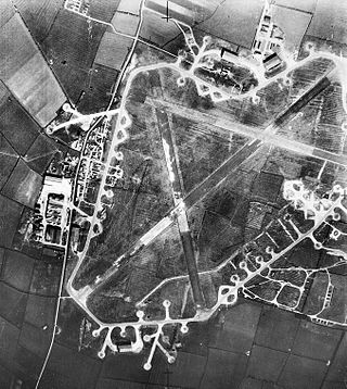
Royal Air Force Fulbeck or more simply RAF Fulbeck is a former Royal Air Force station located 6.3 miles (10.1 km) east of Newark-on-Trent, Nottinghamshire and 10.9 miles (17.5 km) west of Sleaford, Lincolnshire, England.
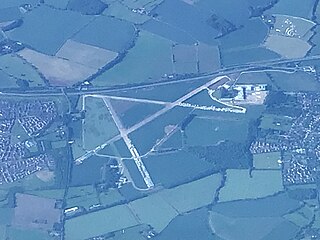
Royal Air Force Langar or more simply RAF Langar is a former Royal Air Force station located near the village of Langar, Nottinghamshire, England. The airfield is located approximately 6 miles (9.7 km) east-southeast of Radcliffe on Trent.

Royal Air Force Gosfield or more simply RAF Gosfield is a former Royal Air Force station in Essex, England. The airfield is located approximately 5 miles (8.0 km) north of Braintree; about 40 miles (64 km) north-northeast of London
Royal Air Force Beaulieu or more simply RAF Beaulieu is a former Royal Air Force station in the New Forest, Hampshire, England. It was also known as Beaulieu airfield, Beaulieu aerodrome and USAAF Station AAF 408. It is located on Hatchet Moor 1 mile (2 km) west of the village of East Boldre, about 2 miles (3 km) west-southwest of the village of Beaulieu and 4 miles (6 km) north-east of Lymington.

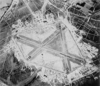
Royal Air Force Balderton or more simply RAF Balderton was a former Royal Air Force satellite station located 2.0 miles (3.2 km) south of Newark-on-Trent, sandwiched between the now extinct Great Northern Railway (GNR) Bottesford-Newark line and the A1 road in Nottinghamshire, England.

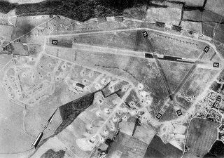
Royal Air Force Bottesford or more simply RAF Bottesford is a former Royal Air Force station located on the Leicestershire-Lincolnshire county border, 6.8 miles (10.9 km) north west of Grantham, Lincolnshire and 7.6 miles (12.2 km) south of Newark-on-Trent, Nottinghamshire.

Royal Air Force Merryfield or more simply RAF Merryfield is a former Royal Air Force station in the village of Ilton near Ilminster in southwest Somerset, England. The airfield is located approximately 7 miles (11 km) north of Chard, about 130 miles (210 km) southwest of London. It is now RNAS Merryfield and serves as a satellite to the larger RNAS Yeovilton; it is used mainly as a training facility for helicopter pilots.
Royal Air Force Bourn or more simply RAF Bourn is a former Royal Air Force station located 2 miles (3.2 km) north of Bourn, Cambridgeshire and 6.9 miles (11.1 km) west of Cambridge, Cambridgeshire, England.

Royal Air Force High Ercall or more simply RAF High Ercall is a former Royal Air Force sector station situated near the village of High Ercall, 7 miles (11 km) northeast of Shrewsbury, Shropshire, England.
Royal Air Force Wymeswold, or more simply RAF Wymeswold, is a former Royal Air Force satellite station located 3.5 miles (5.6 km) north-east of Loughborough, Leicestershire, England. The airfield is situated between Hoton, Wymeswold and Burton on the Wolds, lying in the current district of Charnwood.

Royal Air Force Cheddington or more simply RAF Cheddington is a former Royal Air Force station located 1 mile (1.6 km) south-west of Cheddington, Buckinghamshire, England. The airfield was closed in 1952.


