Royal Air Force Feltwell or more simply RAF Feltwell is a Royal Air Force station in Norfolk, East Anglia that is used by the United States Air Forces in Europe – Air Forces Africa. The station is located about 10 miles west of Thetford, and is in the borough of King's Lynn and West Norfolk at approximate Ordnance Survey grid reference TL 715 900. The site served as a Second World War bomber station, but is now used as a support site for regional AAFES logistics and as a housing estate for United States Air Force personnel stationed nearby at RAF Lakenheath. It is under the administrative control of the 48th Fighter Wing.
Royal Air Force Foulsham, more commonly known as RAF Foulsham is a former Royal Air Force station, a military airfield, located 15 miles North-West of Norwich, in the English county of Norfolk, East Anglia, from 1942 to 1945.

Royal Air Force Polebrook or more simply RAF Polebrook is a former Royal Air Force station located 3.5 miles (5.6 km) east-south-east of Oundle, at Polebrook, Northamptonshire, England. The airfield was built on Rothschild estate land starting in August 1940.

Royal Air Force Goxhill or RAF Goxhill is a former Royal Air Force station located east of Goxhill, on the south bank of the Humber Estuary, opposite the city of Kingston upon Hull, in north Lincolnshire, England.

Royal Air Force Podington, more commonly known as RAF Podington, is a former Royal Air Force station in northern Bedfordshire, England, 6 miles south-east of Wellingborough, Northamptonshire.

Royal Air Force Bassingbourn or more simply RAF Bassingbourn is a former Royal Air Force station located in Cambridgeshire approximately 3 mi (5 km) north of Royston, Hertfordshire and 11 mi (18 km) south west of Cambridge, Cambridgeshire, England.

Royal Air Force Tibenham or more simply RAF Tibenham is a former Royal Air Force station located 13.5 miles (21.7 km) southwest of Norwich and 5.8 miles (9.3 km) north of Diss, Norfolk, England.

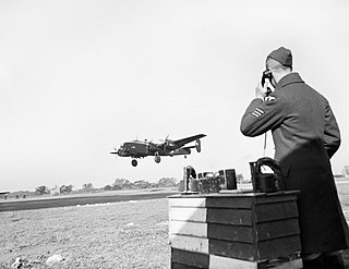
Royal Air Force Wendling or RAF Wendling is a former Royal Air Force station located 5 miles (8.0 km) west-northwest of East Dereham, Norfolk, England.

Royal Air Force Hardwick or more simply RAF Hardwick is a former Royal Air Force station located between the Norfolk villages of Topcroft and Hardwick in England. It is around 5 miles (8.0 km) west of Bungay, Suffolk.

Royal Air Force Seething, or more simply RAF Seething , is a former Royal Air Force station located around 9 NM south-east of Norwich, Norfolk, England. The base was located on the parish boundaries of Seething, Mundham and Hedenham.

Royal Air Force Halesworth or more simply RAF Halesworth is a former Royal Air Force station located 2 miles (3 km) north east of the town of Halesworth, Suffolk, England and 7 miles (11 km) west of Southwold.

Royal Air Force Rackheath, more commonly known as RAF Rackheath, is a former Royal Air Force station located near the village of Rackheath, approximately 6 miles north-east of Norwich, in the county of Norfolk in England.
Royal Air Force Attlebridge, or simply RAF Attlebridge, is a former Royal Air Force station located near Attlebridge and 8 miles (13 km) northwest of Norwich, Norfolk, England.

Royal Air Force Thorpe Abbotts or more simply RAF Thorpe Abbotts is a former Royal Air Force station located 4 miles (6.4 km) east of Diss, Norfolk, in eastern England.
Royal Air Force Framlingham or more simply RAF Framlingham is a former United States Army Air Forces WWII airfield located 3 miles (4.8 km) southeast of Framlingham, and 13 miles (21 km) northeast of Ipswich, Suffolk, England.
Royal Air Force North Creake or more simply RAF North Creake is a former Royal Air Force station located 3.3 miles (5.3 km) southwest of Wells-next-the-Sea, Norfolk and 5.7 miles (9.2 km) northwest of Fakenham, Norfolk, England.
Royal Air Force Lindholme or more simply RAF Lindholme is a former Royal Air Force station in South Yorkshire, England. It was located 3.9 miles (6.3 km) south of Thorne and 6.9 miles (11.1 km) north east of Doncaster and was initially called RAF Hatfield Woodhouse.
Royal Air Force Downham Market, or more simply RAF Downham Market, was a Royal Air Force station in the west of the county of Norfolk, England, which operated during the second half of the Second World War.

Tortorella Airfield is an abandoned World War II military airfield in Italy. It was located 9.4 kilometers east-northeast of Foggia, in the Province of Foggia. The airfield was abandoned and dismantled after the end of the war in 1945.
RAF Holme-on-Spalding Moor, or more simply RAF Holme is a former Royal Air Force station located in Holme-on-Spalding-Moor, East Riding of Yorkshire, England.


