| Raggedtop Mountain | |
|---|---|
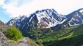
 North aspect | |
| Highest point | |
| Elevation | 5,215 ft (1,590 m) [1] [2] |
| Prominence | 965 ft (294 m) [2] |
| Parent peak | Magpie Peak (5,812 ft) [2] |
| Isolation | 1.77 mi (2.85 km) [2] |
| Coordinates | 61°00′58″N149°08′40″W / 61.0161035°N 149.1444715°W [3] |
| Geography | |
 Raggedtop Mountain Location in Alaska | |
 | |
| Interactive map of Raggedtop Mountain | |
| Location | Municipality of Anchorage |
| Country | United States |
| State | Alaska |
| Protected area | Chugach National Forest [1] |
| Parent range | Chugach Mountains [1] |
| Topo map | USGS Anchorage A-6 |
Raggedtop Mountain is a 5,215-foot-elevation (1,590-meter) mountain summit in Alaska, United States.