Bohol, officially the Province of Bohol, is an island province of the Philippines located in the Central Visayas region, consisting of the island itself and 75 minor surrounding islands. Its capital is Tagbilaran, the largest city of the province. With a land area of 4,821 km2 (1,861 sq mi) and a coastline 261 km (162 mi) long, Bohol is the tenth largest island of the Philippines.

Tagbilaran, officially the City of Tagbilaran, is a 3rd class component city and capital of the province of Bohol, Philippines. According to the 2020 census, it has a population of 104,976 people making it the most populous in the province.

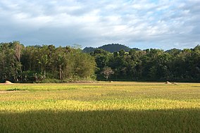
Bilar, officially the Municipality of Bilar, is a 4th class municipality in the province of Bohol, Philippines. According to the 2020 census, it has a population of 18,512 people.

Sikatuna, officially the Municipality of Sikatuna, is a 5th class municipality in the province of Bohol, Philippines. According to the 2020 census, it has a population of 6,906 people.
Datu Sikatuna was a Datu or chieftain of the Bool Kingdom in the island of Bohol in the Philippines. He made a blood compact (sanduguan) and alliance with the Spanish explorer Miguel López de Legazpi on March 25, 1565 at Hinawanan Bay, barangay Hinawanan, Loay. Their blood compact is the first Treaty of Friendship between Spain and the Philippines. The previous site of the pact was thought to have been at barangay Bool, Tagbilaran City but later a panel of historians concluded that the event actually happened at barangay Hinawanan, Loay, Bohol as ratified through Resolution No. 4, issued by the National Historical Institute in 2005.
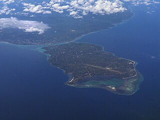
Panglao is an island in the north Bohol Sea, located in the Central Visayas region of the Visayas island group, in the south-central Philippines.

Tagbilaran Airport was an airport that served the general area of Tagbilaran, the capital city of the province of Bohol in the Philippines. The airport was built and opened in the 1960s until it was closed for scheduled passenger services on November 27, 2018, when it was replaced by the new Bohol–Panglao International Airport.
The legislative districts of Bohol are the representations of the province of Bohol in the various national legislatures of the Philippines. The province is currently represented in the lower house of the Congress of the Philippines through its first, second, and third congressional districts.

The rufous-fronted tailorbird is a species of bird formerly placed in the Old World warbler assemblage, but now placed in the family Cisticolidae. It is native to the southern and eastern Philippines. Its natural habitats are tropical moist lowland forests and tropical mangrove forests.

The yellow-breasted tailorbird is a species of passerine bird formerly placed in the "Old World warbler" assemblage, but now placed in the family Cisticolidae. This species is endemic to Philippines on the islands of Bohol, Samar and Leyte. It is known for its bright color relative to other tailorbirds with a yellow body and a striking black head with a white spot under its chin. Its natural habitat is tropical moist lowland forests. It is threatened by habitat loss.
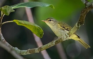
The Philippine leaf warbler is a species of Old World warbler in the family Phylloscopidae. It is endemic to the Philippines on the islands Bohol, Samar, Leyte, Negros, Mindanao, Basilan and the Sulu Archipelago.
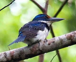
The rufous-lored kingfisher, also known as Winchell's kingfisher, is a species of bird in the kingfisher family Alcedinidae. It is endemic to the Philippines, its natural habitat being lowland forests. It is threatened by deforestation, and the International Union for Conservation of Nature (IUCN) has assessed it as a vulnerable species.

The azure-breasted pitta is a species of bird in the family Pittidae. It is a striking and colorful bird having colors of red, azure, green, black and white, It is endemic to the islands of Mindanao, Bohol, Leyte and Samar in the Philippines. Along with the Whiskered pitta, it is one of two endemic pittas in the country. Its natural habitat is tropical moist lowland forest. It is threatened by habitat loss.

The Philippine jungle flycatcher is a species of passerine bird in the Old World flycatcher family Muscicapidae. It is endemic to the Philippines. Its natural habitat is tropical moist lowland forests up to 1,000 meters above sea level.

The Visayan babbler also known as the Visayan Black-crowned Babbler. is a species of bird in the family Zosteropidae. It is endemic to the Philippines. It is found on Samar, Leyte and Bohol. Its natural habitat is tropical moist lowland forest. It was formerly conspecific to the northern population of the Calabarzon black-crowned babbler but has since been split as a species due to differences in its yellowish throat and whiter belly.

The Philippine hawk-cuckoo is a bird belonging to the cuckoo family. It is found only in the Philippines. It was formerly classified as a subspecies of Hodgson's hawk-cuckoo but is now its own species.

The Visayan blue fantail is a species of bird in the family Rhipiduridae. It is endemic to the Philippines on the islands of Bohol, Leyte and Samar. Its natural habitat is tropical moist lowland forests. It was previously conspecific with the Mindanao blue fantail.

The northern silvery kingfisher is a species of bird in the family Alcedinidae that is endemic to the Philippines being found in the Visayas on the islands of Bohol, Leyte and Samar. This species and the southern silvery kingfisher, which is found on Mindanao, were formerly considered conspecific and called the silvery kingfisher. Its natural habitats are tropical moist lowland forests, streams and rivers. It is threatened by habitat loss.

The Inabanga River is the largest river in Bohol, Philippines. It is 25 kilometres (16 mi) long and up to 7 to 10 metres deep at its mouth at the town of Inabanga.