Yavatmal district, [jəʋət̪maːɭ] formerly known as Yeotmal, is a district of the Indian state of Maharashtra. It is located in the region of Vidarbha, in the east-central part of the state. It is Vidarbha's third-largest district by population, after Nagpur and Amravati. Yavatmal city is the administrative headquarters of the district.
Wardha is a city and a municipal council in Wardha district in the Indian state of Maharashtra. The administrative headquarter of Wardha district is situated here. Wardha gets its name from the Wardha River which flows on the northern, western and southern boundaries of the district. Founded in 1866, the town is now an important centre for cotton trade. Wardha was an important part of the Gandhian era.

Chandrapur district is a district in the Nagpur Division in the Indian state of Maharashtra. Chandrapur was the largest district in India until the Gadchiroli and Sironcha tehsils were separated as Gadchiroli district in 1981. In 2011, the district population was 2,204,307.

Amravati district is a district of Maharashtra state in central India. It is the administrative headquarter of Amravati division, which is one of the two divisions in Vidarbha, out of total 6 regions in state of Maharashtra.

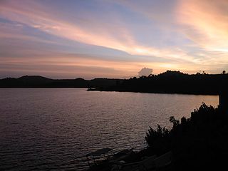
Vengurla is a town in Sindhudurg district of Maharashtra, India just north of Goa. It is surrounded by a semicircular range of hills with lush green foliage mainly of cashew, mango, coconut, and different kinds of berry trees. The hills of Dabholi, Tulas, and Mochemad respectively lie in the north, the east, and the south of Vengurla, while the Arabian Sea is located on its west.

Guna (Gwalior United National Army) is a city and a municipality in Guna district in the Indian state of Madhya Pradesh. It is the administrative headquarters of Guna District under Gwalior Division and is located on the banks of Parbati river.

Amreli is a city and a municipality in Amreli district in Indian state of Gujarat.
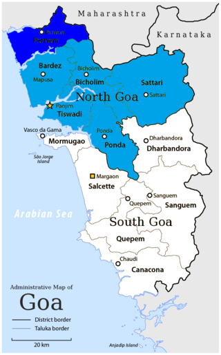
Pernem is a northmost administrative region or sub-district in North Goa in India. It acts as the Gateway of Goa from Maharashtra side. It is also the name of the town of Pernem, which is its headquarters. It has a Municipal Council. Geographically, Pernem is surrounded by Sawantwadi sub-district on East, Arabian Sea on West, Bardez and Bicholim sub-district on south and Sawantwadi sub-district on north. The two rivers which decide the boundary of this sub-district are Terekhol River and Chapora River. Terekhol river acts as a border of Maharashtra and Goa while Chapora river acts as a border of Pernem sub-district and Bardez sub-district.
Udgir is the largest city in Udgir district and Municipal Corporation of the Indian state of Maharashtra. It is located in the Marathwada division of the state. The city is located very close to the borders of Karnataka and Telangana states. Udgir is home to the historical Udgir Fort. The town and nearby villages rely mainly on agriculture, which serves as a major source of income for the population. Udgir city is proposed to be become district, Before independence Udgir is a part of Bidar District Hyderabad kingdom under the rule of Nizam Asifjah VI, After integration of Hyderabad kingdom into India it's become part of Osmanabad district Maharastra Now it is part of Latur District
Ghugus is a census town in Chandrapur district in the Indian state of Maharashtra.
Khanauri is a town and a nagar panchayat in Sangrur district in the state of Punjab, India. It is located at NH 52 at the border of Punjab and Haryana.
Manchar is a census town and Nagar panchayat in Ambegaon taluka of Pune district in the Indian state of Maharashtra. Nearby villages are Kalamb, Pimpalgoan, and Landewadi. It is governed by Manchar Nagar Panchayat which is second Nagar panchayat in the Pune district.
Mowad is a town and a municipal council in Nagpur district of Maharashtra, India. The town is located on the Wardha River.
Pathardi is a town and a municipal council in Ahmednagar district in the Indian state of Maharashtra.

Wani is a 3rd largest city in Yavatmal district in the Indian state of Maharashtra.
Tiosa, or Tivsa, is a town, municipal council, and tehsil in Amravati district in the state of Maharashtra, India.
Peth or Peint is the smallest tehsil of Nashik subdivision of Nashik district in Maharashtra, India. It belongs to Northern Maharashtra region. It belongs to Nashik Division. Peth is a Taluka headquarter. It is located 54 km to the West of Nashik District headquarters. It is also called as Peint. Pin code of Peth is 422208 and postal head office is Peth.
Arvi is a city and municipal council in Wardha district in the state of Maharashtra, India.

Parner taluka is a taluka in Ahmednagar district in the state of Maharashtra in western India.

Khed taluka is a taluka in the subdivision, near Pune city in Pune district of the state of Maharashtra in India. Rajgurunagar is the headquarter of the taluka. The taluka is known for being the birthplace of Santaji Jagnade.The name of city is rajgurunagar on the name of Shaheed Shivram Hari Rajguru.

