
Idukki (ഇടുക്കി), IPA: [iɖukːi], is one of the 14 districts in the Indian state of Kerala. Idukki district lies amid the Cardamom Hills of Western Ghats in Kerala. Idukki district contains two municipal towns - Kattappana and Thodupuzha. The district currently includes five taluks in it.
Thekkady(Idukki district) is a town near Periyar National Park, an important tourist attraction in the Kerala state of India. The name Thekkady is derived from the word "thekku" which means teak. Temperatures are lowest in the months of December–January and highest in the months of April–May.
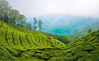
The Cardamom Hills or Yela Mala are mountain range of southern India and part of the southern Western Ghats located in Idukki district, Kerala, India. Their name comes from the cardamom spice grown in much of the hills' cool elevation, which also supports pepper and coffee. The Western Ghats and Periyar Sub-Cluster including the Cardamom Hills are UNESCO World Heritage Sites.

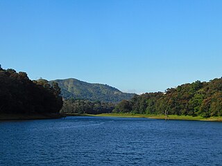
Periyar, IPA: [peɾijɐːr], is the longest river and the river with the largest discharge potential in the Indian state of Kerala. It is one of the few perennial rivers in the region and provides drinking water for several major towns. The Periyar is of utmost significance to the economy of Kerala. It generates a significant proportion of Kerala's electrical power via the Idukki Dam and flows along a region of industrial and commercial activity. The river also provides water for irrigation and domestic use throughout its course besides supporting a rich fishery. Due to these reasons, the river has been named the "Lifeline of Kerala". Kochi city, in the vicinity of the river mouth draws its water supply from Aluva, an upstream site sufficiently free of seawater intrusion. Twenty five percent of Kerala's industries are along the banks of river Periyar. These are mostly crowded within a stretch of 5 kilometres (3 mi) in the Eloor-Edayar region (Udhyogamandal), about 10 kilometres (6 mi) north of Kochi harbor.

The Anamala or Anaimalai, also known as the Elephant Mountains, are a range of mountains in the southern Western Ghats of central Kerala and span the border of western Tamil Nadu in Southern India. The name anamala is derived from the Malayalam word aana and the Tamil word yaanai, meaning elephant, or from tribal languages. Mala or Malai means 'mountain', and thus literally translatable as 'Elephant mountain'.

The Idukki Dam is a double curvature arch dam constructed across the Periyar River in a narrow gorge between two granite hills locally known as Kuravan and Kurathi in Idukki, Kerala, India. At 168.91 metres (554.2 ft), it is one of the highest arch dams in Asia. It is constructed and owned by the Kerala State Electricity Board. It supports a 780 MW hydroelectric power station in Moolamattom, which started generating power on 4 October 1975. The dam type is a concrete, double curvature parabolic, thin arc dam. The Indo-Canadian project was inaugurated by the Prime Minister Indira Gandhi on February 17, 1976.
Cumbum, natively spelt as Kambam, is a town and municipality in Theni district, an Indian state of Tamil Nadu.

Theni is a town and a municipality in Theni district in the Indian state of Tamil Nadu. As of 2011, the town had a population of 94,453. The metro area had the population of 202,100.
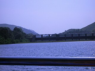
Mullaperiyar DamIPA: [mulːɐpːeɾijɐːr], is a masonry gravity dam on the Periyar River in the Indian state of Kerala It is located 881 m (2,890 ft) above the sea level, on the Cardamom Hills of the Western Ghats in Thekkady, Idukki District of Kerala, India. It was constructed between 1887 and 1895 by John Pennycuick and also reached in an agreement to divert water eastwards to the Madras Presidency area. It has a height of 53.6 m (176 ft) from the foundation, and a length of 365.7 m (1,200 ft). The Periyar National Park in Thekkady is located around the dam's reservoir. The dam is built at the confluence of Mullayar and Periyar rivers. The dam is located in Kerala on the river Periyar, but is operated and maintained by the neighbouring state of Tamil Nadu. Although the Periyar River has a total catchment area of 5398 km2 with 114 km2 downstream from the dam in Tamil Nadu, the catchment area of the Mullaperiyar Dam itself lies entirely in Kerala and thus not an inter-State river. On 21 November 2014, the water level hit 142 feet for first time in 35 years. The reservoir again hit the maximum limit of 142 feet on 15 August 2018, following incessant rains in the state of Kerala. In a UN report published in 2021, the dam was identified as one among the world's big dams which needs to be decommissioned for being 'situated in a seismically active area with significant structural flaws and poses risk to 3.5 million people if the 100+ years old dam were to fail'.

Poonjar is a small Indian town located on the eastern side of Kottayam district in Kerala state, India. Before the independence of India, Poonjar had been the part of Travancore princely state.Erattupetta, Teekoy, bharananganam, and vagamon are the nearest towns and villages of Poonjar.Taluk headquarters,pala is 18 kilometres away from poonjar and kanjirapally is 22.6 kilometres away from poonjar

Kumily, also spelt as Kumaly is a revenue village and Gram Panchayat in the Idukki district of Kerala. It is a town in Cardamom Hills near Thekkady and Periyar Tiger Reserve. Kumily is a gateway town into Kerala from Tamil Nadu.
Nedumkandam is the headquarters of Udumbanchola taluk which is situated in Idukki district of the Indian state of Kerala. Nedumkandam is among the fastest growing towns in the Idukki district. Nedumkandam is well known for its spices production and is a major contributor to the production of spices like cardamom and pepper. This town situated an average elevation of 900 meter above sea level and maximum elevation respectively 1190 meter 1100 meter and 975 meter and is a destination for economical stay and shopping for tourists in the popular Kumily-Munnar tourist route.
Thookupalam is a developing commercial centre about 10 kilometres (6.2 mi) from the Kerala-Tamil Nadu border in the Idukki district of Kerala, India. It lies on the banks of river Kallar and is one of the main tourist hubs between Thekkady, Munnar and Ramakkalmedu.
Tamil Nadu has the largest tourism industry in India with a percentage share of 21.31% and 21.86% of domestic and foreign tourist visits in the country. According to the 2020 Ministry of Tourism report, the number of domestic arrivals was at 494.8 million making the state the second most popular tourist destination in the country, and foreign arrivals numbered 6.86 million, the highest in the country, making it the most popular state for tourism in the country.
Kuravanmala is a location in Idukki district, Kerala, India. It is the location of the Idukki Dam.

Anakkara is a geographic area of around 50 square kilometres that spans across Vandanmedu, Chakkupallam Panchayats in the Udumbanchola Taluk of Idukki District. Anakkara is the administrative capital of Chakkupallam Grama Panchayat and Anakkara Revenue Village. Situated at about 18 kilometers (11 mi) from Thekkady wildlife sanctuary on the Kumily-Munnar state highway, Anakkara is a fast-growing tourist destination for its unique spice gardens and many picnic spots in and around. It is one of the 36 distinct places identified by Government of India and United Nations Development Programme for exploring and promoting the unique tourism potential of these places.

Bodimettu is a locality in Theni district in the state of Tamil Nadu in India, near the border with Kerala. It is 10 km from Poopara on the way to Bodinayakkanur by the side of National Highway 85, which runs from Dhanushkodi to Kochi. Bodimettu is the main cardamom-growing area of Tamil Nadu. It is close to famous tourist destinations such as Munnar, Marayur, Thekkady, Kodaikanal, Anayirangal Dam.
The Kuravar/Kurunjiyar/MoothaKudi is an ethnic Tamil community native to the Kurinji mountain region of Tamil Nadu and Kerala, India. As of September 2021, the Kuravars have been unable to attain status as a scheduled tribe.
Sabarimala Railway is a proposed 111 kilometres (69 mi) railway line from Angamaly to Erumeli, near Sabarimala that was sanctioned in 1998 by Indian Railways. According to a memorandum of understanding signed between the Kerala State and the Ministry of Railways on 27 January 2016, commercially viable railway projects will be identified and handed over to the Special Purpose Vehicle (SPV) to be fast-tracked on a 51:49 per cent equity basis. The SPV has discussed the extension to Punalur. The currently proposed Sabarimala railway is under PMO - Proactive government and timely implementation (Pragati); will be monitored by the Prime Minister's Office. The proposed railway line will be a great relief to the transportation problems faced by Idukki, Kottayam, and Pathanamthitta districts. Railways have agreed to start the project once the Kerala Rail Development Corporation gives the revised estimate for the project.

Panchalimedu is a hill station and view point near Kuttikkanam in Peerumedu tehsil of Idukki district in the Indian state of Kerala. On the Makar Sankranti day, many Ayyappa devotees camps there to witness the sacred Makaravilakku that appears in the Ponnambalamedu near Sabarimala temple.

 view from ramakkalmedu
 ramakkalmedu viewpoint
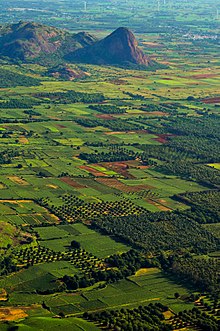
 view of tamilnadu from ramakkalmedu viewpoint
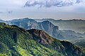 view from ramakkalmedu viewpoint
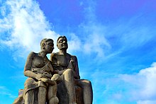
 kuravan kurathi statue, ramakkalmedu
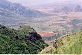 Views from Ramakkalmade
 Side view of Kuravan and Kurathi
 Tourist at Ramakkalmedu viewpoint
 an outcrop of rock jutting to tamilnadu scenery
 View of Tamil Nadu from Ramakkalmedu


