Bakkhali is a village within the jurisdiction of the Namkhana police station in the Namkhana CD block in the Kakdwip subdivision of the South 24 Parganas district in the Indian state of West Bengal.
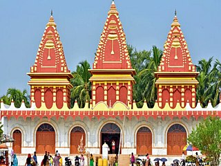
Sagar Island is an island in the Ganges delta, lying on the continental shelf of Bay of Bengal about 100 km south of Kolkata. This island forms the Sagar CD Block in Kakdwip subdivision of South 24 Parganas district in the Indian State of West Bengal. Although Sagar Island is a part of Sundarbans, it does not have any tiger habitation or mangrove forests or small river tributaries as is characteristic of the overall Sundarban delta. This island is a place of Hindu pilgrimage. Every year on the day of Makar Sankranti, hundreds of thousands of Hindus gather to take a holy dip at the confluence of river Ganges and Bay of Bengal and offer prayers (puja) in the Kapil Muni Temple. Kolkata Port Trust has a pilot station and a light house.
Basanti is a census town and a gram panchayat within the jurisdiction of the Basanti police station in the Basanti CD block in the Canning subdivision of the South 24 Parganas district in the Indian state of West Bengal.
Kultali is a village within the jurisdiction of the Kultali police station in the Kultali CD block in the Baruipur subdivision of the South 24 Parganas district in the Indian state of West Bengal.

Kakdwip subdivision is an administrative subdivision of the South 24 Parganas district in the Indian state of West Bengal.

Patharpratima is a community development block that forms an administrative division in the Kakdwip subdivision of the South 24 Parganas district in the Indian state of West Bengal.

Kakdwip is a town of the South 24 Parganas district in the Indian state of West Bengal. It is situated on the eastern banks of the Hooghly River. It is the headquarters of the Kakdwip subdivision.

Kakdwip is a community development block that forms an administrative division in the Kakdwip subdivision of the South 24 Parganas district in the Indian state of West Bengal.

Sagar is a community development block that forms an administrative division in the Kakdwip subdivision of the South 24 Parganas district in the Indian state of West Bengal.
Gangasagar is a village and a gram panchayat in the Sagar CD block in the Kakdwip subdivision of the South 24 Parganas district in the Indian state of West Bengal.

Namkhana is a village and a gram panchayat within the jurisdiction of the Namkhana police station in the Namkhana CD block in the Kakdwip subdivision of the South 24 Parganas district in the Indian state of West Bengal.
Dhola is a census town and a gram panchayat within the jurisdiction of the Kulpi police station in the Kulpi CD block in the Diamond Harbour subdivision of the South 24 Parganas district in the Indian state of West Bengal.
Ganespur is a village within the jurisdiction of the Kakdwip police station in the Kakdwip CD block in the Kakdwip subdivision of the South 24 Parganas district in the Indian state of West Bengal.
Rudranagar is a village and a gram panchayat within the jurisdiction of the Sagar police station in the Sagar CD block in the Kakdwip subdivision of the South 24 Parganas district in the Indian state of West Bengal.
Harinbari is a village within the jurisdiction of the Sagar police station in the Sagar CD block in the Kakdwip subdivision of the South 24 Parganas district in the Indian state of West Bengal.
Harwood Point is a village within the jurisdiction of the Kakdwip police station in the Kakdwip CD block in the Kakdwip subdivision of the South 24 Parganas district in the Indian state of West Bengal.
Fraserganj is a village and a gram panchayat within the jurisdiction of the Namkhana police station in the Namkhana CD block in the Kakdwip subdivision of the South 24 Parganas district in the Indian state of West Bengal.
Gobardhanpur is a village within the jurisdiction of the Patharpratima police station in the Patharpratima CD block in the Kakdwip subdivision of the South 24 Parganas district in the Indian state of West Bengal.

The Sundarbans settlements refer to the areas of the Sundarbans that were cleared of forests for human habitation in the present North 24 Paganas and the South 24 Parganas districts in the Indian state of West Bengal.
Patharpratima is a village and a gram panchayat within the jurisdiction of the Patharpratima police station in the Patharpratima CD block in the Kakdwip subdivision of the South 24 Parganas district in the Indian state of West Bengal.


