Amtala is a census town within the jurisdiction of the Bishnupur police station in the Bishnupur II CD block in the Alipore Sadar subdivision of the South 24 Parganas district in the Indian state of West Bengal.
Chak Enayetnagar is a census town and a gram panchayat within the jurisdiction of the Bishnupur police station in the Bishnupur II CD block in the Alipore Sadar subdivision of the South 24 Parganas district in the Indian state of West Bengal.
Chak Kashipur is a census town within the jurisdiction of the Nodakhali police station in the Budge Budge II CD block in the Alipore Sadar subdivision of the South 24 Parganas district in the Indian state of West Bengal.
Kanyanagar is a census town within the jurisdiction of the Bishnupur police station in the Bishnupur I CD block in the Alipore Sadar subdivision of the South 24 Parganas district in the Indian state of West Bengal.
Bishnupur is a census town within the jurisdiction of the Bishnupur police station in the Bishnupur I CD block in the Alipore Sadar subdivision of the South 24 Parganas district in the Indian state of West Bengal.
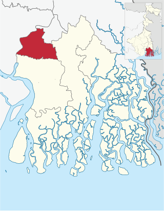
Alipore Sadar subdivision is an administrative subdivision of the South 24 Parganas district in the Indian state of West Bengal.
Asuti is a census town and a gram panchayat within the jurisdiction of the Maheshtala police station in the Thakurpukur Maheshtala CD block in the Alipore Sadar subdivision of the South 24 Parganas district in the Indian state of West Bengal.
Daulatpur is a census town in the Bishnupur I CD block in the Alipore Sadar subdivision of the South 24 Parganas district in the Indian state of West Bengal.
Bhasa is a census town within the jurisdiction of the Bishnupur police station in the Bishnupur I CD block in the Alipore Sadar subdivision of the South 24 Parganas district in the Indian state of West Bengal.
Nahazari is a census town and a gram panchayat within the jurisdiction of the Bishnupur police station in the Bishnupur II CD block in the Alipore Sadar subdivision of the South 24 Parganas district in the Indian state of West Bengal.
Nadabhanga is a census town within the jurisdiction of the Bishnupur police station in the Bishnupur II CD block in the Alipore Sadar subdivision of the South 24 Parganas district in the Indian state of West Bengal.
Kanganbaria is a census town and a gram panchayat within the jurisdiction of the Bishnupur police station in the Bishnupur II CD block in the Alipore Sadar subdivision of the South 24 Parganas district in the Indian state of West Bengal.
Bora Gagangohalia is a census town within the jurisdiction of the Bishnupur police station in the Bishnupur II CD block in the Alipore Sadar subdivision of the South 24 Parganas district in the Indian state of West Bengal.
Chandandaha is a census town within the jurisdiction of the Bishnupur police station in the Bishnupur II CD block in the Alipore Sadar subdivision of the South 24 Parganas district in the Indian state of West Bengal.
Barkalikapur is a census town within the jurisdiction of the Bishnupur police station in the Bishnupur II CD block in the Alipore Sadar subdivision of the South 24 Parganas district in the Indian state of West Bengal.
Ramkrishnapur is a census town and a gram panchayat within the jurisdiction of the Bishnupur police station in the Bishnupur II CD block in the Alipore Sadar subdivision of the South 24 Parganas district in the Indian state of West Bengal.
Kriparampur is a census town within the jurisdiction of the Bishnupur police station in the Bishnupur II CD block in the Alipore Sadar subdivision of the South 24 Parganas district in the Indian state of West Bengal.
Bakhrahat is a village and a gram panchayat within the jurisdiction of the Bishnupur police station in the Bishnupur II CD block in the Alipore Sadar subdivision of the South 24 Parganas district in the Indian state of West Bengal. Along with a Boys' School, Bakhrahat also has the Bakhrahat Girls' High School, which is situated on Borokachari Road.
Doultabad is a village within the jurisdiction of the Bishnupur police station in the Bishnupur I CD block in the Alipore Sadar subdivision of the South 24 Parganas district in the Indian state of West Bengal.
Vidyanagar is a village within the jurisdiction of the Bishnupur police station in the Bishnupur II CD block in the Alipore Sadar subdivision of the South 24 Parganas district in the Indian state of West Bengal.


