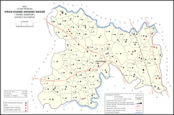
Baramadpur is a village in Akhand Nagar block of Kadipur tehsil in Sultanpur district of Uttar Pradesh, India. As of 2011, it has a population of 3,251 people, in 442 households. It has one primary school and one primary health centre and it hosts both a regular market and a weekly haat. It is part of the nyaya panchayat of Sajampur.
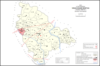
Gairikpur is a village in Bhetua block of Amethi district in Uttar Pradesh, India. As of 2011, its population is 1,754 people, in 275 households. It has one primary school and no healthcare facilities and does not host a permanent market or weekly haat. It serves as the headquarters of a nyaya panchayat that also includes 15 other villages.

Chak Nizam is a village in Rahi block of Rae Bareli district, Uttar Pradesh, India. It is located 8 km from Rae Bareli, the district headquarters. As of 2011, it has a total population of 806 people, in 137 households. It has one primary school and no medical facilities and it does not host a weekly haat or a permanent market. It belongs to the nyaya panchayat of Bhaon.
Paraura is a village in Rahi block of Rae Bareli district, Uttar Pradesh, India. It is located 13 km from Rae Bareli, the district headquarters. As of 2011, it has a total population of 1,060 people, in 191 households. It has one primary school and no medical facilities and it does not host a weekly haat or a permanent market. It belongs to the nyaya panchayat of Bhaon.
Raipur Maheri is a village in Rahi block of Rae Bareli district, Uttar Pradesh, India. It is located 10 km from Rae Bareli, the district headquarters. As of 2011, it has a total population of 1,753 people, in 314 households. It has one primary school and no medical facilities and it does not host a weekly haat or a permanent market. It belongs to the nyaya panchayat of Bhadokhar.
Chak Lodipur is a village in Rahi block of Rae Bareli district, Uttar Pradesh, India. It is located 8 km from Rae Bareli, the district headquarters. As of 2011, it has a total population of 449 people, in 89 households. It has one primary school and no medical facilities and it does not host a weekly haat or a permanent market. It belongs to the nyaya panchayat of Rustampur.
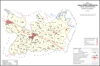
Gaimau is a village in Jagdishpur block of Sultanpur district, Uttar Pradesh, India. It is located 50 km from Sultanpur, the district headquarters. As of 2011, it has a population of 1,617 people, in 255 households. It has one primary school and no healthcare facilities and does not host a permanent market or weekly haat. It belongs to the nyaya panchayat of Harimau.
Sajampur is a village in Akhand Nagar block of Kadipur tehsil in Sultanpur district of Uttar Pradesh, India. As of 2011, it has a population of 1,749 people, in 246 households. It has one primary school and no healthcare facilities and it does not host a regular market or a weekly haat. It serves as the seat of a nyaya panchayat which also includes 13 other villages.
Muradabad is a village in Akhand Nagar block of Kadipur tehsil in Sultanpur district, Uttar Pradesh, India. As of 2011, it has a population of 1,543 people, in 238 households. It has one primary school and no healthcare facilities and it hosts both a regular market and a weekly haat. It belongs to the nyaya panchayat of Sajampur.
Karai is a village in Akhand Nagar block of Kadipur tehsil in Sultanpur district, Uttar Pradesh, India. As of 2011, it has a population of 1,399 people, in 196 households. It has one primary school and no healthcare facilities and it does not host a regular market or a weekly haat. It belongs to the nyaya panchayat of Sajampur.
Raipur is a village in Akhand Nagar block of Kadipur tehsil in Sultanpur district, Uttar Pradesh, India. As of 2011, it has a population of 1,738 people, in 307 households. It has one primary school and no healthcare facilities and it does not host a regular market or a weekly haat. It belongs to the nyaya panchayat of Sajampur.

Daulatpur is a village in Kadipur block of Kadipur tehsil in Sultanpur district, Uttar Pradesh, India. As of 2011, it has a population of 1,261 people, in 172 households. It has one primary school and no healthcare facilities and it does not host a regular market or a weekly haat. It belongs to the nyaya panchayat of Kalikapur Kalan.

Masirpur is a village in Jaisinghpur block of Sultanpur district, Uttar Pradesh, India. As of 2011, it has a population of 967 people, in 163 households. It has no schools and no healthcare facilities. It belongs to the nyaya panchayat of Jaisinghpur.
Daulatpur is a village in Jaisinghpur block of Sultanpur district, Uttar Pradesh, India. As of 2011, it has a population of 974 people, in 169 households. It has one primary school and no healthcare facilities and it does not host a permanent market or weekly haat. It belongs to the nyaya panchayat of Saraiya.

Bhawanshahpur is a village in Gauriganj block of Amethi district, Uttar Pradesh, India. As of 2011, it has a population of 821 people, in 154 households. It has no schools and no healthcare facilities and does not host a permanent market or weekly haat. It belongs to the nyaya panchayat of Semuai.
Biswan is a village in Gauriganj block of Amethi district, Uttar Pradesh, India. As of 2011, it has a population of 353 people, in 55 households. It has no schools and no healthcare facilities and hosts both a permanent market and a weekly haat. It belongs to the nyaya panchayat of Semuai.
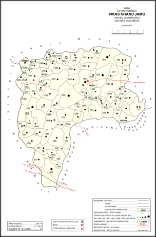
Dakhinwara is a village in Jamo block of Amethi district, Uttar Pradesh, India. As of 2011, it has a population of 3,840 people, in 613 households. It has two primary schools and one maternity and child welfare centre and it hosts a weekly haat but not a periodic market. It belongs to the nyaya panchayat of Jamo.
Piparpur is a village in Bhetua block of Amethi district, Uttar Pradesh, India. As of 2011, it has a population of 1,025 people, in 186 households. It has one primary school and no healthcare facilities and hosts a weekly haat but not a permanent market. It belongs to the nyaya panchayat of Amey Maphi.
Thaura is a village in Bhetua block of Amethi district, Uttar Pradesh, India. As of 2011, it has a population of 2,403 people, in 382 households. It has one primary school and no healthcare facilities and hosts a weekly haat but not a permanent market. It belongs to the nyaya panchayat of Bhetua.
Naugirwa is a village in Bhetua block of Amethi district, Uttar Pradesh, India. As of 2011, it has a population of 1,168 people, in 220 households. It has one primary school and a veterinary hospital and hosts a weekly haat but not a permanent market. It belongs to the nyaya panchayat of Darai Mafi.