Rappville, New South Wales

Last updated

Rappville
New South Wales
Australia New South Wales location map blank.svg
Red pog.svg
Rappville
Location in New South Wales
Coordinates 29°5′S152°57′E / 29.083°S 152.950°E / -29.083; 152.950 Coordinates: 29°5′S152°57′E / 29.083°S 152.950°E / -29.083; 152.950
Population169 (2016 census) [1]
Postcode(s) 2469
Elevation51 m (167 ft)
Location
LGA(s) Richmond Valley Council
Region Northern Rivers
County Richmond
Parish Nandabah
State electorate(s) Clarence
Federal division(s) Page
Localities around Rappville:
Casino
Rappville Woodburn
Whiporie

Rappville is a small village in northern New South Wales, Australia. At the 2016 census, Rappville recorded a population of 169 people.

Contents

History

The district in which Rappville is situated was initially developed by European settlers for cattle grazing (for example the very extensive Wooroowoolga Station) and forestry (first, cedar getting, then other species) from the 1840s onwards; to these rural industries was added dairying, which became an important component from the 1860s for almost the next 100 years. [2] Initially, rural products were transported by road and the network of navigable rivers, however in 1903 the small but growing North Coast railway line reached Casino and two years later was extended south to Grafton. A sawmiller named John Murray established his sawmill by the new railway in an area initially called Murray's Siding, to exploit both the local supply of timber and the onward rail connections first to Casino and thence to the then inland port town of Lismore, sited at the highest navigable point of an arm of the Richmond (later renamed Wilsons) River. It appears that whole logs were also loaded for downstream milling, as may be judged by the following item appearing in the Sydney Morning Herald for 15 November 1906:

LARGE TIMBER TRAIN.

LISMORE, Wednesday.

A special timber train, which arrived here from Murray's siding, Grafton-Casino line, consisted of 13 eight-wheel waggons and six other vehicles. It was the longest and heaviest timber train seen here. Two engines were used to bring the train from Casino. The consignment, about 400 tons, was for the Richmond River Timber Company. About 400 tons of log timber are brought in weekly, 37 to 40 miles, for that company, and the British-Australia Company's mills, formerly Dorrough's. Large quantities of timber are obtained from other sources. [3]

With the thriving timber cutting, sawmilling, and outbound timber supply industry, the nucleus of a new settlement grew up around the siding which by 1910 contained a butcher, a blacksmith, a small store, a school (opened in 1908), a church (opened in 1910, dedicated in 1911) and a bakery; it was formally gazetted as "Rappville" in March 1911, [4] named after a prominent early settler and businessman Henry Rapp, who first selected land in the area in 1888. In the same year, Rapp opened his new Commercial Hotel, designed by the local architectural firm of Popplewell and Sykes, on a site opposite the small Rappville Railway Station. [5] (By 1923 the rail link was extended south to Sydney and by 1930 to north to Brisbane, opening up the whole of the north coast of New South Wales to rail traffic); Rapp's Commercial Hotel operated using the licence from a previous establishment of the same name owned by his wife's mother in the neighbouring settlement of Myrtle Creek, of which virtually nothing now remains. 1911 also saw construction of a new railway station allowing passengers to alight and take their lunches at the newly constructed hotel and adjacent tea rooms. Other businesses in the village included a second butcher, an ice works, a second produce store and a branch of the Bank of New South Wales which also operated as a post office. [6]

Through to the 1930s the village was fairly prosperous but has declined since then, in part because of a move of much passenger and freight traffic from rail to road as well as the gradual reduction of the timber industry. [7] In 1997, a community workshop/discussion session in the village as input to the North East New South Wales Regional Forest Agreement identified additional factors contributing to population decline since the 1980s including the increased difficulty of making a living from cattle grazing, the closure of nearby cattle yards and small timber mills, the loss of railway/sleeper workers following the closure of a local railway sleeper yard in 1987, and the loss of customers visiting the pub following the introduction of new drink-driving laws; however this was partially offset by the establishment of commercial tea tree plantations in the region as well as a modest influx of newcomers from the city attracted by cheap land prices in the area. [6]

The Sydney-Brisbane railway line continues to pass through the village, although the station has long closed and associated buildings have since disappeared. [8] The most prominent building in the village is still the Commercial Hotel, also known as the Rappville Pub. [9] The village also contains a post office, a hall, an Anglican church (St. John's, which celebrated its Centenary in 2011) and a primary school. The hotel was due to be closed in 2016 on account of difficulty in meeting current fire regulations, [10] but is presently (2019) open and under restoration, having changed hands in 2017. In 2008, the village played host to the film crew of the popular U.K. Television series "Heartbeat" who filmed parts of two episodes at the Hotel, as part of a plotline which took the cast and crew to Australia following a murder mystery. [11]

An additional local item of interest is the remains of a bush tea tree still: distillation of tea tree oil from native bushes was a subsidiary occupation for farmers in the area, until it was replaced by production from commercial plantations in the 1970s. [12] Commercial cultivation of the local tea tree plant, Melaleuca alternifolia, which is native to the area and thrives in the flat, seasonally swampy habitat that surrounds Rappville, is now very successful. In a 2013 article, Main Camp Natural Extracts near Rappville was described as "the world's largest commercial plantation" of tea tree for oil, with 1,500 hectares of tea tree under production at its peak, with half of that figure remaining as at 2013; [13] according to the company's website in 2019, its Myrtle Creek property currently spans some 4,300 ha and using sustainable practices, regenerates over 30 million tea trees each year on laser leveled land. [14]

The area which includes Rappville lies in the traditional lands of the Aboriginal Bundjalung Nation, and contained speakers of the Birrihn (or Biriin) dialect. [15]

2019 bushfire disaster

In October 2019 the village was devastated as a destructive bushfire that started in Busbys Flat raced through the residential area, leading to the loss of at least 15 houses although no lives were believed to have been lost. The village's pub and primary school were saved although the hall was destroyed. The fire also resulted in significant damage to the Sydney-Brisbane railway line, loss of local power and telecommunications infrastructure, and closure of adjacent highways to traffic in several places. [16] [17]

Bibliography

Related Research Articles

<span class="mw-page-title-main">Byron Bay</span> Town in New South Wales, Australia

Byron Bay is a beachside town located in the far-northeastern corner of the state of New South Wales, Australia on Bundjalung Country. It is located 772 kilometres (480 mi) north of Sydney and 165 kilometres (103 mi) south of Brisbane. Cape Byron, a headland adjacent to the town, is the easternmost point of mainland Australia. At the 2021 census, the town had a permanent population of 6,330. It is the largest town of Byron Shire, though not the shire's administrative centre.

<span class="mw-page-title-main">Northern Rivers</span> Region in New South Wales, Australia

Northern Rivers is the most north-easterly region of the Australian state of New South Wales, located between 590 and 820 kilometres north of the state capital, Sydney, and encompasses the catchments and fertile valleys of the Clarence, Richmond, and Tweed rivers. It extends from Tweed Heads in the north to the southern extent of the Clarence river catchment which lies between Grafton and Coffs Harbour, and includes the main towns of Tweed Heads, Byron Bay, Ballina, Kyogle, Lismore, Casino and Grafton. At its most northern point, the region is 102 kilometres (63 mi) south-southeast of the Queensland capital, Brisbane.

<span class="mw-page-title-main">Ballina, New South Wales</span> Town in New South Wales, Australia

Ballina is a town in the Northern Rivers region of New South Wales, Australia, and the seat of the Ballina Shire local government area. Ballina's urban population at June 2018 was 26,381. The town lies on the Richmond River and serves as a gateway to Byron Bay.

<span class="mw-page-title-main">Summerland Way</span>

Summerland Way is a 199–kilometre state route, designated B91, in New South Wales. It runs generally north from Grafton to the state border with Queensland just west of Mount Lindesay, and continues from there into Queensland as Mount Lindesay Highway. It was named as the region in runs through is a popular tourist area for people during summer.

<span class="mw-page-title-main">Kyogle</span> Town in New South Wales, Australia

Kyogle is a town in the Northern Rivers region of northern New South Wales, Australia. It falls within the local government area of Kyogle Council. At the 2016 census, Kyogle had a population of 2,751 people. Kyogle is known as a "gateway" to many national parks including Border Ranges National Park and Toonumbar National Park.

<span class="mw-page-title-main">Casino, New South Wales</span> Town in New South Wales, Australia

Casino is a town in the Northern Rivers area of New South Wales, Australia, with a population of 10,914 people at the 2016 census. It lies on the banks of the Richmond River and is situated at the junction of the Bruxner Highway and the Summerland Way.

<span class="mw-page-title-main">Bonalbo</span> Town in New South Wales, Australia

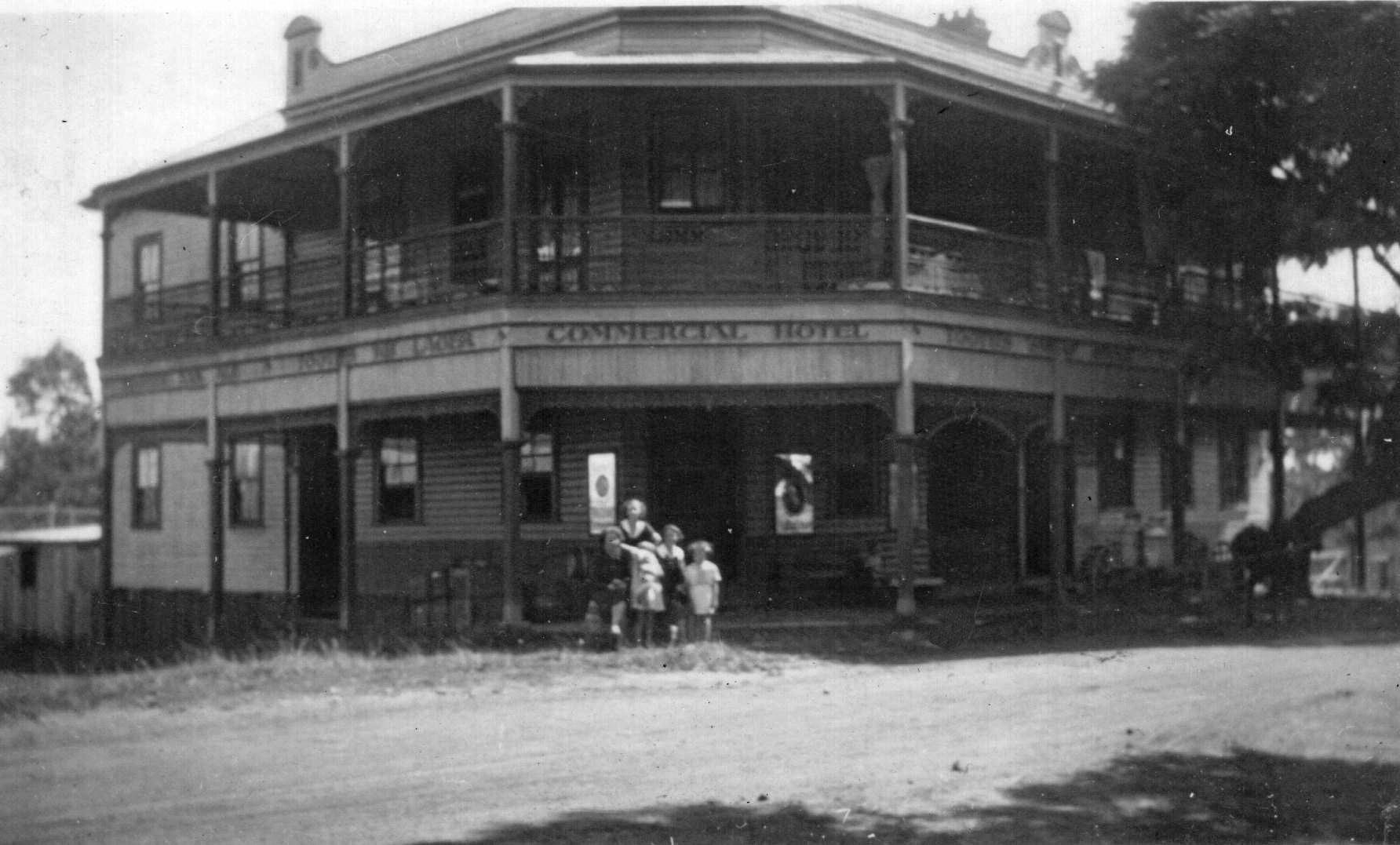
Bonalbo, a rural village in the Northern Rivers region of New South Wales, Australia, is located 815 kilometres (506 mi) north-east of Sydney. In the 2011 census, Bonalbo and the surrounding area had a population of 371. The town's name derives from the Gidabal word bunawalbu meaning "bloodwood trees".

<span class="mw-page-title-main">Mullumbimby</span> Town in New South Wales, Australia

Mullumbimby is an Australian town in the Byron Shire in the Northern Rivers region of New South Wales. It promotes itself as "The Biggest Little Town in Australia". The town lies at the foot of Mount Chincogan in the Brunswick Valley about 9 kilometres by road from the coast. At the 2016 census, Mullumbimby and the surrounding area had a population of 3,596 people.

<span class="mw-page-title-main">Carcoar, New South Wales</span> Town in New South Wales, Australia

Carcoar is a town in the Central West region of New South Wales, Australia, in Blayney Shire. In 2016, the town had a population of 200 people. It is situated just off the Mid-Western Highway 258 km west of Sydney and 52 km south-west of Bathurst and is 720 m above sea level. It is located in a small green valley, with the township and buildings on both banks of the Belubula River. It is the third oldest settlement west of the Blue Mountains. Carcoar is a Gundungurra word meaning either frog or kookaburra. Nearby towns are Blayney, Millthorpe, Mandurama, Neville, Lyndhurst and Barry

<span class="mw-page-title-main">Coraki, New South Wales</span> Town in New South Wales, Australia

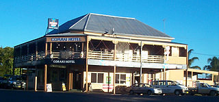
Coraki is a small town that sits on the confluence of the Richmond and Wilson Rivers in northern New South Wales, Australia in Richmond Valley Shire. At the 2016 census, Coraki had a population of 1,277 people.

<span class="mw-page-title-main">Schofields, New South Wales</span> Suburb of Sydney, New South Wales, Australia

Schofields is a suburb on the fringe of Sydney's urban sprawl, in the state of New South Wales, Australia. Schofields is located 45 kilometres (28 mi) north-west of the Sydney central business district, in the Blacktown local government area. It is part of Greater Western Sydney's North West Growth Area.

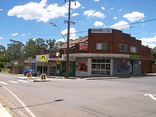
Tatham is a locality in New South Wales, Australia in Richmond Valley Shire. The name Tatham is derived from Bundjalung Jadham, meaning "child".

<i>Toona ciliata</i> Species of tree

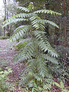
Toona ciliata is a forest tree in the mahogany family which grows throughout southern Asia from Afghanistan to Papua New Guinea and Australia.

<span class="mw-page-title-main">Nerrigundah, New South Wales</span> City in New South Wales, Australia

Nerrigundah is a small village on the Eurobodalla Nature Coast in south eastern New South Wales. Situated at the head of the Tuross River Valley, it is nineteen kilometres inland from Bodalla. At the 2016 census, Nerrigundah had a population of 25.

<span class="mw-page-title-main">Torrington, New South Wales</span> Town in New South Wales, Australia

Torrington is a small village in northern New South Wales in Tenterfield Shire. It is 29 kilometres north west of Deepwater and south west of Tenterfield and 61 kilometres from Glen Innes (South-East). It is situated on a plateau known as the Mole Tableland in close proximity to the Queensland border on the Northern Tablelands. A feature of Torrington is its abundance of boulders and rocky outcrops. The most notable boulder outcrop located in the village being "Goat Rock" and just out of town is "Old Mystery Face"

<span class="mw-page-title-main">Dorrigo, New South Wales</span> Town in New South Wales, Australia

Dorrigo, a small town on the Waterfall Way, is located on the Northern Tablelands, in northern New South Wales, Australia. The town is part of Bellingen local government area.

<span class="mw-page-title-main">Casino railway station</span> Australian railway station

Casino railway station is a heritage-listed railway station on the North Coast line in New South Wales, Australia. Opening on 22 September 1930, it serves the town of Casino in the Richmond Valley Shire. It was added to the New South Wales State Heritage Register on 2 April 1999.

The Bundjalung people are a large Aboriginal nation, a federation of a number of groups of clans which occupy the land from Grafton on the Clarence river of northern New South Wales north to the town of Ipswich and the Beaudesert, in southern Queensland, and down around the other side of the Great Dividing Range and back to Grafton. In the north, Bundjalung Nation shares a border with Yuggera Nation and Barrunggam Nation; to the east the Tasman Sea ; to the south Gumbaynggirr Nation; and to the west it borders Ngarabal Nation.

<span class="mw-page-title-main">Monga, New South Wales</span> Town in New South Wales, Australia

Monga is a locality in the Queanbeyan-Palerang Region, Southern Tablelands, New South Wales, Australia. It lies on the Kings Highway at the top of the Clyde Mountain, about 110 km east of Canberra and 22 km southeast of Braidwood. A large part of the locality forms part of the Monga National Park. At the 2016 census, it had a population of 14.

Dalmorton is a locality in the Northern Rivers region of New South Wales, Australia. There once was a village of the same name, which was associated with gold mining. Much of the area of the locality is now reserved as National Parks or State Forests. At the 2016 census, the population of Dalmorton was four.

References

  1. Australian Bureau of Statistics (27 June 2017). "Rappville (State Suburb)". 2016 Census QuickStats. Retrieved 6 January 2018. OOjs UI icon edit-ltr-progressive.svg
  2. Gardiner, pp. 74–75
  3. The Sydney Morning Herald Thu 15 Nov 1906 Page 5 LARGE TIMBER TRAIN. Available via trove.nla.gov.au
  4. "Village Lands at Rappville". Department of Lands, Sydney, 22 March 1911. Government Gazette of the State of New South Wales (Sydney, NSW : 1901 – 2001), p. 1732.
  5. Gardiner, p. 52
  6. 1 2 Anonymous, 1999: "Social Assessment NSW Upper North EAST CRA Regions: A report undertaken for the NSW CRA/RFA Steering Committee, 22 September 1999". Available online at http://www.agriculture.gov.au/SiteCollectionDocuments/rfa/regions/nsw-north-east/social-economic/social-assessment/upper-ne-nsw/social-assessment-report-une.pdf
  7. Gardiner, p. 73
  8. Rappville station. NSWrail.net, accessed 1 September 2009.
  9. Rappville. Australian explorer, accessed 1 September 2009.
  10. "Tiny town of Rappville rallies to save historic pub". ABC News. 20 September 2016. Retrieved 11 October 2019.
  11. "Rappville just a Heartbeat away from fame". Northern Star. 26 August 2008. Retrieved 12 October 2019.
  12. Gardiner, pp. 75–76
  13. "Troubled waters for oils". The Land. 24 November 2013. Retrieved 12 October 2019.
  14. "Main Camp Natural Extracts: The Property". Main Camp Natural Extracts. Retrieved 12 October 2019.
  15. "Bundjalung Nation – Planet Corroboree". planetcorroboree.com.au. Retrieved 11 October 2019.
  16. "RAPPVILLE HIT: Homes lost to fire, saving lives a priority". www.northernstar.com.au. 8 October 2019. Retrieved 11 October 2019.
  17. "Rappville residents take stock after bushfire rips through the northern New South Wales town". ABC News. 10 October 2019. Retrieved 11 October 2019.

Further reading

{

Preceding stationFormer ServicesFollowing station
Coombell
towards Brisbane
North Coast Line Myrtle Creek
towards Maitland