Rat, Missouri

Last updated

Rat, Missouri
Unincorporated community
USA Missouri location map.svg
Red pog.svg
Rat
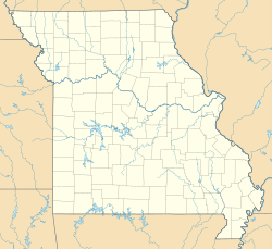
Location within the state of Missouri
Coordinates: 37°22′21″N91°13′39″W / 37.37250°N 91.22750°W / 37.37250; -91.22750
Country United States
State Missouri
County Shannon
Township Moore
Time zone UTC-6 (Central (CST))
 • Summer (DST) UTC-5 (CDT)
Area code 573
GNIS feature ID751809 [1]

Rat is an unincorporated community in northeast Shannon County, in the U.S. state of Missouri. [1] The community is adjacent to Big Creek, approximately six miles south-southwest of Bunker. [2]

History

A post office called Rat was established in 1898, and remained in operation until it was discontinued in 1954. [3] The community was named "Rat" in protest after postal authorities denied the townspeople their first choice of "Buckshorn". [4] Rat has been noted for its unusual place name. [5]

References

  1. 1 2 U.S. Geological Survey Geographic Names Information System: Rat, Missouri
  2. ↑ Missouri Atlas & Gazetteer, DeLorme, 1998, First edition, p. 55, ISBN   0-89933-224-2
  3. ↑ "Shannon County". Jim Forte Postal History. Retrieved June 8, 2015.
  4. ↑ "Shannon County Place Names, 1928–1945". The State Historical Society of Missouri. Archived from the original on October 21, 2019. Retrieved December 18, 2024.
  5. ↑ LIFE. January 31, 1944. p. 57. ISSN   0024-3019.