
Clark County is a county located in the U.S. state of Missouri. As of the 2010 census, the county's population was 7,139. Its county seat is Kahoka. The county was organized December 16, 1836 and named for William Clark, leader of the Lewis and Clark Expedition and later Governor of Missouri Territory.

Fulton is the largest city in and the county seat of Callaway County, Missouri, United States. Located about 22 miles (35 km) northeast of Jefferson City and the Missouri River and 20 miles (32 km) east of Columbia, the city is part of the Jefferson City, Missouri, Metropolitan Statistical Area. The population was 12,790 in the 2010 census. The city is home to two universities, Westminster College and William Woods University; the Missouri School for the Deaf; the Fulton State Hospital; and the Fulton Reception and Diagnostic Center state prison.

Peculiar is a city in Cass County, Missouri and is part of the Kansas City metropolitan area within the United States. The population was 4,608 at the 2010 census. The town motto is "Where the 'odds' are with you."
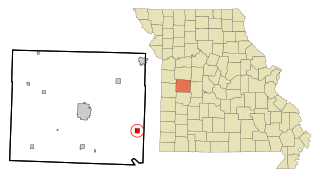
Tightwad is a village in Henry County, Missouri, United States. Its population was 64 at the 2010 United States Census. Tightwad is located along Missouri Route 7.

Akers is an unincorporated community in northwestern Shannon County, Missouri, United States. It is located approximately eighteen miles northwest of Eminence in the Ozark National Scenic Riverways. Akers houses a campground and access to the Current River. Since there is no bridge within the community, there is a small ferry that allows vehicles traveling on Highway K to cross the Current River.
Alley Spring is an unincorporated community in Shannon County, Missouri, United States. It is located six miles west of Eminence on Route 106. The scenic Alley Mill, or "Old Red Mill" is located there on a spring and is located in the Ozark National Scenic Riverways. The Mill is operated as an Ozarks history museum. Nearby a one room schoolhouse and general store add to the feeling of the restored historic hamlet. It once had a post office, but it is now closed and mail now comes from Eminence. The community is named after John Alley, a miller. It was originally named Mammoth Spring and later Barksdale Spring. These names were deemed too long by the Post Office Department of the time, so the village was renamed after a prominent local citizen, John Alley.
Mine La Motte is an unincorporated community and census-designated place in Madison County, Missouri, United States. It is located approximately six miles north of Fredericktown. Europeans discovered lead here and had also hoped to find silver. The French Governor of Louisiana, Antoine de la Mothe Cadillac, failed to find silver, but succeeded in recruiting investors in The Company of the West, which was organized in 1717. Mine La Motte was eventually settled by about 200 French settlers along with their slaves from Santo Domingo, under the leadership of Philip François Renault, to develop mines in 1717, making it one of the oldest settlements west of the Mississippi River. The presence of lead, a critical ingredient for ammunition, attracted unusually early mining by French colonists in this otherwise remote interior region of the North American continent. That same lead, still used for ammunition at the time of the American Civil War, was also a factor in the Battle of Fredericktown in which forces aligned with the Confederate States of America fought for control of the lead smelters in nearby Fredericktown with the Unionist forces, aligned with the United States of America.
Dutzow is an unincorporated community in southeastern Warren County, Missouri, United States. It is located on Route 94, approximately three miles north of Washington. Located near the Missouri River, it is one of the oldest German communities in the state.
Wolf Island is an unincorporated community in eastern Mississippi County, Missouri, United States. It is located on Route 77, approximately nine miles east of East Prairie.
Wittenberg is an unincorporated community in Brazeau Township in eastern Perry County, Missouri, United States. It is located on the Mississippi River, 14 miles (23 km) southeast of Perryville. Wittenberg is situated in the Brazeau Bottoms on Brazeau Creek opposite Grand Tower, Illinois, and Tower Rock, the latter a landmark island in the Mississippi River.

Uniontown is an unincorporated community located in Union Township in southeastern Perry County, Missouri, United States. It is situated on U.S. Route 61, ten miles southeast of Perryville.

Kaiser is an unincorporated community in Miller County in the U.S. state of Missouri. It is located on a county road just south of Route 42/134. The zip code is 65047.

Portland is an unincorporated community in southeastern Callaway County, Missouri, United States. It is part of the Jefferson City, Missouri Metropolitan Statistical Area. Portland is located just north of the Missouri River on Route 94, approximately 24 miles east-northeast of Jefferson City.
Owls Bend is an unincorporated community in eastern Shannon County, in the Ozarks of southern Missouri, United States. The community is located adjacent to the Current River, northeast of the Missouri Route 106 crossing and the Powder Mill Creek campground.
Cedargrove is an extinct town in the northwest corner of Shannon County, in the Ozarks of southern Missouri. The GNIS classifies it as a populated place. The community is located just south of the Shannon - Dent county line on the Current River, just north of the Big Creek confluence with the Current. It lies at the end of Missouri Route B, two miles east of the Shannon - Texas county line.
Rector is an extinct town in northwest Shannon County, in the U.S. state of Missouri. The GNIS classifies it as a populated place. The community is located in Rector Hollow, which is a tributary to Gladden Creek approximately one mile to the west. It is on Missouri Route J two miles west of Missouri Route 19.
Round Spring is an unincorporated community in Shannon County, in the U.S. state of Missouri. The site is located on Missouri Route 19, adjacent to the confluence of Spring Valley Creek with the Current River.
Timber is an unincorporated community in northern Shannon County, in the Ozarks of southern Missouri. The community is located on Missouri Route 19, south of Shannondale.
Venice is an unincorporated community in Shannon County, in the U.S. state of Missouri. The community is located on Missouri Route 19, northwest of Eminence and south of Round Spring.
Nile is an unincorporated community in eastern Texas County, in the U.S. state of Missouri. The community is situated on the floodplain of Big Creek, approximately one mile west of the Texas-Shannon county line. The old Nile Schoolhouse was about one mile east (upstream) and on the opposite side of the river across a stream ford.

