Alley Spring, Missouri

Last updated
Alley Spring
Alley Spring and Mill in November 2021.jpg
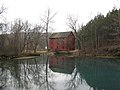
Alley Spring, Mill, and bluff in autumn
USA Missouri location map.svg
Red pog.svg
Alley Spring
Location within the state of Missouri
Coordinates: 37°8′39″N91°26′38″W / 37.14417°N 91.44389°W / 37.14417; -91.44389 Coordinates: 37°8′39″N91°26′38″W / 37.14417°N 91.44389°W / 37.14417; -91.44389
Country United States
State Missouri
County Shannon
Township Eminence
Elevation
[1]
679 ft (207 m)
Time zone UTC-6 (Central (CST))
  Summer (DST) UTC-5 (CDT)
GNIS feature ID713232 [1]

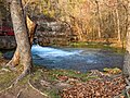
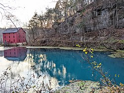
Alley Spring is an unincorporated community in Shannon County, Missouri, United States. It is located six miles west of Eminence on Route 106. The scenic Alley Mill, or "Old Red Mill" is located there on a spring and is located in the Ozark National Scenic Riverways. The Mill is operated as an Ozarks history museum. Nearby a one room schoolhouse and general store add to the feeling of the restored historic hamlet. It once had a post office, but it is now closed and mail now comes from Eminence. The community is named after John Alley, a miller. It was originally named Mammoth Spring and later Barksdale Spring. These names were deemed too long by the Post Office Department of the time, so the village was renamed after a prominent local citizen, John Alley.

Contents

History

A post office called Alley was established in 1884, the name was changed to Alley Spring in 1950, and the post office closed in 1974. [2] The community has the name of John Alley, original owner of the town site. [3]

Geography

The National Park Service operates a large campground at Alley. There is a small convenience store and canoe rental as well. Canoeing is very popular on the Jacks Fork River which runs through Alley.

Arts and culture

The Haunting in the Hills is an annual event held at Alley Spring. It consists of traditional Ozark demonstrations and a storytelling event, Tales from Ozark's Dark Side. The annual event takes place the second weekend of October. All Events are free to the public.

Related Research Articles

<span class="mw-page-title-main">Shannon County, Missouri</span> County in Missouri, United States

Shannon County is a county in the southern portion of the U.S. state of Missouri. As of the 2020 census, the population was 7,031. Its county seat is Eminence. The county was officially organized on January 29, 1841, and was named in honor of George F. "Peg-Leg" Shannon, a member of the Lewis and Clark Expedition. It is the second-largest county by area in Missouri.

<span class="mw-page-title-main">Carter County, Missouri</span> County in Missouri, United States

Carter County is a county in the Ozarks of Missouri. At the 2020 census, it had a population of 5,202. The largest city and county seat is Van Buren. The county was officially organized on March 10, 1859, and is named after Zimri A. Carter, a pioneer settler who came to Missouri from South Carolina in 1812.

<span class="mw-page-title-main">Eminence, Missouri</span> City in Missouri, United States

Eminence is a city in Shannon County, Missouri, United States. The population was 515 at the 2020 census. It is the county seat of Shannon County.

<span class="mw-page-title-main">Ozarks</span> Highland region in central-southern United States

The Ozarks, also known as the Ozark Mountains, Ozark Highlands or Ozark Plateau, is a physiographic region in the U.S. states of Missouri, Arkansas, Oklahoma and the extreme southeastern corner of Kansas. The Ozarks cover a significant portion of northern Arkansas and most of the southern half of Missouri, extending from Interstate 40 in central Arkansas to Interstate 70 in central Missouri.

<span class="mw-page-title-main">Current River (Ozarks)</span> River in Arkansas, United States

The Current River forms in the southeastern portion of the Ozarks of Missouri and becomes a 7th order stream as it flows southeasterly out of the Ozarks into northeastern Arkansas where it becomes a tributary of the Black River, which is a tributary of the White River, a tributary of the Mississippi River. The Current River is approximately 184 miles (296 km) long and drains about 2,641 square miles (6,840 km2) of land mostly in Missouri and a small portion of land in northeastern Arkansas. The headwaters of the Current River are nearly 900 feet (270 m) above sea level, while the mouth of the river lies around 280 feet (85 m) above sea level. The basin drains a rural area that is dominated by karst topography, underlain by dolomite and sandstone bedrock with a small area of igneous rock southeast of Eminence, Missouri. The annual daily mean discharge of the river near Doniphan, Missouri is 2,815 cubic feet (79.7 m3) per second. In 1964, over 134 mi (160 km) of the upper course of the river and its tributaries were federally protected as the Ozark National Scenic Riverways, the first national park in America to protect a river system.

Almartha is an unincorporated community in northern Ozark County, Missouri, United States. It is located approximately thirteen miles north of Gainesville and four miles southeast of Wasola on Route 95. The village is located in a valley on a tributary of Spring Creek. Several homes are located there. The old mill and current fish hatchery of Rockbridge lies downstream on Spring Creek, about six miles to the east.

<span class="mw-page-title-main">Sycamore, Missouri</span> Community in Missouri, U. S. A.

Sycamore is an unincorporated community in eastern Ozark County in the Ozarks of southern Missouri, United States. It is located on Route 181, approximately fourteen miles northeast of Gainesville. The old townsite is located on a ridge on the west side of Bryant Creek, a major tributary of the North Fork River. The old Hodgson Mill and spring lie on Bryant Creek 0.8 mi (1.3 km) to the northeast. The mill was nominated to the National Register of Historic Places as Aid-Hodgson Mill in 2001.

Akers is an unincorporated community in northwestern Shannon County, Missouri, United States. It is located approximately eighteen miles northwest of Eminence in the Ozark National Scenic Riverways. Akers houses a campground and access to the Current River. Since there is no bridge within the community, there is a small ferry that allows vehicles traveling on Highway K to cross the Current River.

<span class="mw-page-title-main">Montauk, Missouri</span>

Montauk is an unincorporated community in southwestern Dent County, Missouri, United States. It is located on Route 119, on the Current River and is in the Ozark National Scenic Riverways. Montauk State Park, famed for its rainbow and brown trout, is here.

<span class="mw-page-title-main">Montauk State Park</span> State park in Missouri, United States

Montauk State Park is a public recreation area occupying nearly 3,000 acres (1,200 ha) at the headwaters of the Current River, fifteen miles (24 km) southwest of Salem, Missouri. The state park contains a fish hatchery and is noted for its rainbow and brown trout angling. It was acquired in 1926. The park has several natural springs including Montauk Spring with a daily average flow of 53 million gallons of water.

<span class="mw-page-title-main">Ozark National Scenic Riverways</span>

The Ozark National Scenic Riverways is a recreational unit of the National Park Service in the Ozarks of southern Missouri in the U.S.

<span class="mw-page-title-main">Jacks Fork</span> River in the United States of America

Jacks Fork is one of two rivers in Missouri that are part of the Ozark National Scenic Riverways system.

Big Sugar Creek is a 47-mile-long (76 km) waterway in the Ozark Mountains of southwest Missouri. The creek starts near the Arkansas state line. Big Sugar starts from three tributaries. One flows north from Garfield, Arkansas, and one, west near Seligman, Missouri, and another, south from Washburn, Missouri. Big Sugar flows west down Sugar Creek Valley, where in the Jacket community it is joined by Otter Creek, from Pea Ridge, Arkansas.

<span class="mw-page-title-main">Eleven Point National Wild and Scenic River</span>

The Eleven Point National Wild and Scenic River is a 44-mile (71 km) stretch of the spring-fed Eleven Point River in the Ozarks of southern Missouri set aside through eminent domain for preservation by Congress in 1968. The designated part of the river stretches from Thomasville to State Highway 142. The river was included in the original proposal for the Ozark National Scenic Riverways, but it was ultimately excluded when the Riverways were designated on the Current and Jacks Fork rivers in 1964.

Shawnee is an historic unincorporated community in Shannon County, in the Ozarks of southern Missouri, United States. The community was located on Little Shawnee Creek, approximately two miles southeast of Eminence at an elevation of 825 feet. The location is along County Road 507, about midway between Missouri Route 106 to the north and Missouri Route H to the southeast.

<span class="mw-page-title-main">Alley Spring Roller Mill</span> United States historic place

The Alley Spring Roller Mill, also known as Red Mill, is a historic grist mill located in the Ozark National Scenic Riverways near Eminence, Shannon County, Missouri. It was built in 1893, and is a 2 1/2-story, rectangular frame building on a limestone block foundation. It measures 32 feet by 42 feet and houses four steel rollers and a single stone burr.

<span class="mw-page-title-main">Reed Log House</span> United States historic place

Reed Log House, also known as Macy Cabin, Prather House and Keller House , is a historic home located in the Ozark National Scenic Riverways near Eminence, Shannon County, Missouri. It was built in 1857, with two additions dating from about 1885 and 1910. It is a one-story, vernacular Ozark pine log structure with vertical board siding on a stone foundation.

Button Rock School, also known as the Buttin School, and District #85 School, is a historic one-room school building and national historic district located in the Ozark National Scenic Riverways near Eminence, Shannon County, Missouri. The school was built in 1913, and is a one-story, rectangular frame building on a pier foundation. It has a gable roof and is sheathed in novelty siding painted white. Also on the property is a contributing frame privy.

<span class="mw-page-title-main">Chilton-Williams Farm Complex</span> United States historic place

Chilton-Williams Farm Complex, also known as Chilton Place, is a historic farm complex and national historic district located in the Ozark National Scenic Riverways near Eminence, Shannon County, Missouri. The district encompasses 15 contributing buildings and 2 contributing structures associated with a post-American Civil War Ozark farm. It developed between about 1869 and 1879 and includes the Chilton House, Williams-Baltz House, gambrel roofed barn, four small barns, two corn cribs, smokehouse, five sheds, privy, storm cellar, and chicken house.

<span class="mw-page-title-main">Walter Klepzig Mill and Farm</span> United States historic place

Walter Klepzig Mill and Farm is a historic farm and sawmill and national historic district located in the Ozark National Scenic Riverways near Eminence, Shannon County, Missouri. The district encompasses three contributing buildings, three contributing sites, and one contributing structure associated with an early-20th century Ozark farm and mill. It developed between about 1912 and 1936 and includes the mill and its related hydraulic system ; a spring house and smokehouse ; foundations of a 1923 farmhouse and barn ; and two post-1934 chicken coops and a ruin of a post-1934 machine shed.

References

  1. 1 2 U.S. Geological Survey Geographic Names Information System: Alley Spring, Missouri
  2. "Post Offices". Jim Forte Postal History. Retrieved 25 December 2016.
  3. "Shannon County Place Names, 1928–1945". The State Historical Society of Missouri. Archived from the original on June 24, 2016. Retrieved December 25, 2016.