Raukokore

Last updated

Raukokore
01 east coast Raukokore Church.jpg
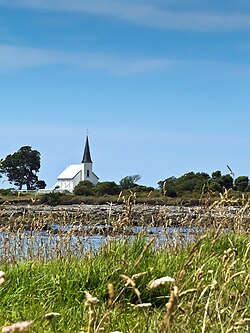
Raukokore's Anglican church
Raukokore
Coordinates: 37°38′38″S177°52′35″E / 37.644°S 177.8764°E / -37.644; 177.8764
CountryNew Zealand
Region Bay of Plenty
Territorial authority Ōpōtiki District
WardCoast Ward
CommunityCoast Community
Electorates
Government
  Territorial authority Ōpōtiki District Council
  Regional council Bay of Plenty Regional Council
Area
[1]
  Total34.43 km2 (13.29 sq mi)
Population
 (2018 Census) [2]
  Total141
  Density4.1/km2 (11/sq mi)

Raukokore is a small settlement close to the East Cape in the northeastern North Island of New Zealand. It is located on State Highway 35, close to the mouth of the Raukokore River, 40 kilometres to the west of Hicks Bay.

Contents

Raukokore's most notable feature is its Anglican church, Christ Church, a landmark of the East Cape region, which stands isolated close to the shore of Papatea Bay. The church was named as one of the East Cape/Gisborne region's "101 must-do" sites by the New Zealand Automobile Association. [3] The church was designed and built by Duncan Stirling in 1894. Stirling married local Raukokore chief Mihi Kōtukutuku in the church in 1896. The church is listed as a Category 1 Historic Place by Heritage New Zealand. [4]

Raukokore is administered by the Ōpōtiki District Council.

Demographics

Raukokore is in an SA1 statistical area which covers 34.43 km2 (13.29 sq mi). [1] The SA1 area is part of the wider Cape Runaway statistical area. [5]

Historical population
YearPop.±% p.a.
2006150    
2013168+1.63%
2018141−3.44%
Source: [2]

Raukokore had a population of 141 at the 2018 New Zealand census, a decrease of 27 people (−16.1%) since the 2013 census, and a decrease of 9 people (−6.0%) since the 2006 census. There were 66 households, comprising 81 males and 57 females, giving a sex ratio of 1.42 males per female. The median age was 47.9 years (compared with 37.4 years nationally), with 33 people (23.4%) aged under 15 years, 9 (6.4%) aged 15 to 29, 63 (44.7%) aged 30 to 64, and 33 (23.4%) aged 65 or older.

Ethnicities were 38.3% European/Pākehā, 78.7% Māori, and 2.1% Pacific peoples. People may identify with more than one ethnicity.

Although some people chose not to answer the census's question about religious affiliation, 36.2% had no religion, 44.7% were Christian, and 6.4% had Māori religious beliefs.

Of those at least 15 years old, 9 (8.3%) people had a bachelor's or higher degree, and 33 (30.6%) people had no formal qualifications. The median income was $22,800, compared with $31,800 nationally. 9 people (8.3%) earned over $70,000 compared to 17.2% nationally. The employment status of those at least 15 was that 45 (41.7%) people were employed full-time, 18 (16.7%) were part-time, and 9 (8.3%) were unemployed. [2]

Marae

The settlement is in the rohe of the iwi of Te Whānau-ā-Apanui and has two marae affiliated with local hapū .

In October 2020, the Government committed $205,700 from the Provincial Growth Fund to develop Wairūrū Marae, creating 8 jobs. [8]

Notable people

Related Research Articles

<span class="mw-page-title-main">Tokomaru Bay</span> Town in the North Island of New Zealand

Tokomaru Bay is a small beachside community on the remote East Coast of New Zealand's North Island. It is 91 km north of Gisborne, on State Highway 35, and close to Mount Hikurangi. The district was originally known as Toka-a-Namu, which refers to the abundance of sandflies. Over the years the name was altered to Tokomaru Bay.

<span class="mw-page-title-main">Cape Runaway</span> Cape and locality in the Bay of Plenty, New Zealand

Cape Runaway is the eastern extremity of the Bay of Plenty in New Zealand's North Island. It is located 157 kilometres northeast off Whakatāne and 65 kilometres west of East Cape.

<span class="mw-page-title-main">Murupara</span> Town in the Bay of Plenty Region, New Zealand

Murupara is a town in the Whakatāne District and Bay of Plenty Region of New Zealand's North Island. The town is in an isolated part of the region between the Kaingaroa Forest and Te Urewera protected area, on the banks of the Rangitaiki River, 65 kilometres southeast of Rotorua. Indigenous Māori also make up over 90% of the population.

<span class="mw-page-title-main">Ruatoria</span> Town in the Gisborne District of New Zealand

Ruatoria is a town in the Waiapu Valley of the Gisborne Region in the northeastern corner of New Zealand's North Island. The town was originally known as Cross Roads then Manutahi and was later named Ruatorea in 1913, after the Māori Master female grower Tōrea who had some of the finest storage pits in her Iwi at the time (Te-Rua-a-Tōrea). In 1925 the name was altered to "Ruatoria", although some texts retain the original spelling.

<span class="mw-page-title-main">Te Kaha</span> Town in Bay of Plenty, New Zealand

Te Kaha is a small New Zealand community situated in the Bay of Plenty near Ōpōtiki. The New Zealand Ministry for Culture and Heritage gives a translation of "the rope" for Te Kaha. The full name of Te Kaha is Te-Kahanui-A-Tikirākau. Te Kaha is a little outpost that contains a couple of dairies and the Te Kaha resort.

<span class="mw-page-title-main">Te Poi</span> Settlement in Waikato, New Zealand

Te Poi is a small village in rural Waikato, New Zealand, established in 1912 at the base of the Kaimai Range. Te Poi is part of a thriving farming area, particularly for dairying, thoroughbred horse breeding and cropping.

<span class="mw-page-title-main">Te Whānau-ā-Apanui</span> Māori iwi in New Zealand

Te Whānau-ā-Apanui is a Māori iwi (tribe) located in the eastern Bay of Plenty and East Coast regions of New Zealand's North Island. In 2006, the iwi registered 11,808 members, representing 13 hapū.

Kaeo is a township in the Far North District of New Zealand, located some 22 km (14 mi) northwest of Kerikeri. The town's name comes from the Māori-language name of the New Zealand freshwater mussel, which is found in nearby rivers.

<span class="mw-page-title-main">Te Araroa (town)</span> Town in the Gisborne District of New Zealand

Te Araroa is a town in the Gisborne Region of the North Island of New Zealand. It is 175 km north of Gisborne city, along State Highway 35 between Tokata and Awatere. Te Araroa is the birthplace of noted Māori politician Sir Āpirana Ngata. Māori in the area are generally associated with the Ngāti Porou iwi. It is 100 metres from its local beach.

<span class="mw-page-title-main">Te Hāpua</span> Place in Northland Region, New Zealand

Te Hāpua is a community on the shores of the Parengarenga Harbour in Northland, New Zealand. The road to Te Hāpua leaves State Highway 1 at Waitiki Landing.

<span class="mw-page-title-main">Te Kao</span> Place in Northland Region, New Zealand

Te Kao is a village on the Aupouri Peninsula of Northland, New Zealand. Te Aupōuri are mana whenua over Te Kao and the surrounding district, and it is the principal settlement of the iwi (tribe). Te Aupōuri's Post-Settlement Governance Entity, Te Runanga Nui o Te Aupōuri, has an office at Te Kao, along with the iwi's marae and urupa. State Highway 1 passes through the district. Cape Reinga is 46 km to the north, and Houhora is 24 km to the south. The Aupouri Forest and Ninety Mile Beach are to the west.

Pukepoto is a town in Northland, New Zealand. It lies south west of Kaitaia and north east of Ahipara. The Herekino Forest lies to the south east.

<span class="mw-page-title-main">Whangape Harbour</span> Harbor in Northland, New Zealand

Whangape Harbour is a harbour on the west coast of Northland, New Zealand. There is a settlement called Whangape on the northern side of the harbour. Another, called Pawarenga, is located on the southern side. Kaitaia is 42 km north east.

Panguru is a community in the northern Hokianga harbour, in Northland, New Zealand. The Whakarapa Stream flows from the Panguru Range in the Warawara Forest to the west, through Panguru and into the Hokianga.

Rawhiti is a small beachfront town about 27km from Russell in the Bay of Islands of New Zealand.

Motatau or Mōtatau is a locality in the Northland Region of the North Island of New Zealand. Maromaku is to the east. The Taikirau Stream flows from east through Motatau and then runs northwest to join the Waiharakeke Stream. The North Auckland Line runs through Motatau.

Hoani Retimana Waititi was a notable New Zealand teacher, educationalist and community leader. Of Māori descent, he identified with the Te Whānau-ā-Apanui iwi. He was born in Whangaparaoa near Cape Runaway, Bay of Plenty, New Zealand, in 1926. His father was Kūaha Waititi, a farmer, and his mother was Kirimātao Heremia Kerei, both of them of the Te Whānau-a-Kauaetangohia hapū of Te Whānau-ā-Apanui. He trained as a teacher in 1947–48 and gained a BA at in 1955. He worked as a teacher and in other areas of education. He died of cancer at the age of 39. Hoani Waititi Marae in West Auckland is named in his honour. June Mariu is his niece, the daughter of his older brother Manihera. Rawiri Waititi is his great-nephew.

Waimana is a rural valley in the Whakatāne District and Bay of Plenty Region of New Zealand's North Island. It is located in the northern Te Urewera. Waimana River, originally known as Tauranga River, runs through the valley, joining the Ohinemataroa River one kilometre south-west of Tāneatua.

Hexton is a village and rural area in the Gisborne District of New Zealand's North Island. It is located north-west of Gisborne City, and includes the settlements of Makauri and Waerengaahika.

<span class="mw-page-title-main">June Mariu</span> New Zealand Māori community leader, educator and sportswoman

Dame Mabel June Hinekahukura Mariu, known by most as "Aunty June", is a New Zealand Māori community leader, teacher, former sportswoman and served as a Justice of the Peace for many years before retiring.

References

  1. 1 2 "ArcGIS Web Application". statsnz.maps.arcgis.com. Retrieved 14 January 2023.
  2. 1 2 3 "Statistical area 1 dataset for 2018 Census". Statistics New Zealand. March 2020. 7015409.
  3. "Raukokore Church". aatravel.co.nz. New Zealand Automobile Association.
  4. "Christ Church, Raukokore". heritage.org.nz. Heritage New Zealand.
  5. 2018 Census place summary: Cape Runaway
  6. "Te Kāhui Māngai directory". tkm.govt.nz. Te Puni Kōkiri.
  7. "Māori Maps". maorimaps.com. Te Potiki National Trust.
  8. "Marae Announcements" (Excel). growregions.govt.nz. Provincial Growth Fund. 9 October 2020.