
Munster Township is a township in Cambria County, Pennsylvania, United States. The population was 690 at the 2010 census. It is part of the Johnstown, Pennsylvania Metropolitan Statistical Area.

Alvinópolis is a Brazilian municipality in the state of Minas Gerais. As of 2004 its population is estimated to be 15,723. The city belongs to the mesoregion Metropolitana de Belo Horizonte and to the microregion of Itabira.
East Amherst is a suburban hamlet 16 miles (26 km) northeast of downtown Buffalo, New York, Erie County, New York, United States. It straddles the towns of Amherst and Clarence, and comprises the majority of ZIP code 14051, and some surrounding areas.
Castle Rock Hoodoos Provincial Park is a provincial park in British Columbia, Canada. Located on the Deadman Plateau northwest of Kamloops, the park was originally named the Deadman Hoodoos Provincial Park and was created on July 23, 1997 and was 34 hectares in size. The park was reduced in size to 16 hectares on April 11, 2001, and renamed at the same time.
Moriah Shock Incarceration Correctional Facility is a minimum security New York State prison, located in Mineville, Town of Moriah, Essex County, New York, in a remote part of the Adirondack Mountains. The facility — established in former mine buildings — is home to SHOCK and intensive ASAT programs. It usually houses about 300 inmates.
The Addison-2 Representative District is a one member state Representative district in the U.S. state of Vermont. It is one of the 108 one or two member districts into which the state was divided by the redistricting and reapportionment plan developed by the Vermont General Assembly following the 2000 U.S. Census. The plan applies to legislatures elected in 2002, 2004, 2006, 2008, and 2010. A new plan will be developed in 2012 following the 2010 U.S. Census.
Streeters Corners, New York is a hamlet in the town of Cambria in Niagara County, New York, United States. Neither the placename nor any early settler in Cumbria named Streeter appear in the "History of Cambria, New York" included in William Pool, ed. Landmarks of Niagara County, New York.

Big Prairie is an unincorporated community in northwestern Ripley Township, Holmes County, Ohio, United States. Although it is unincorporated, it has a post office, with the ZIP code of 44611. It lies less than one mile east of Odell Lake.
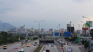
A roundabout interchange is a type of interchange between a controlled access highway, such as a motorway or freeway, and a minor road. The slip roads to and from the motorway carriageways converge at a single roundabout, which is grade-separated from the motorway lanes with bridges.

Otisco is an unincorporated community in Charlestown Township, Clark County, Indiana.
Pendleton Center, New York is a hamlet in the town of Pendleton in Niagara County, New York, United States.
Sandy Beach, New York is a hamlet in the town of Grand Island in Erie County, New York, United States. It is located to the east of Buckhorn Island State Park.
Sand Hill, New York is a hamlet in the town of Newstead in Erie County, New York, United States.
Swifts Mills, New York is a hamlet in the town of Newstead in Erie County, New York, United States.
Pekin, New York is a hamlet in the towns of Cambria and Lewiston in Niagara County, New York, United States. It was a stop in the Underground Railroad.
Colonial Village, New York is a hamlet in the town of Lewiston in Niagara County, New York, United States.
Gilberts Corners, New York is a hamlet in the town of Royalton in Niagara County, New York, United States.
East Wilson, New York is a hamlet in the town of Wilson in Niagara County, New York, United States. The hamlet was formerly called "Beebe's Corners"
Thorold Co-generation Plant is a natural gas-fired station owned by Northland Power, brought into operation on March 28, 2010. The plant also supplies steam to the nearby AbitibiBowater paper mill. Power is produced under contract to the Ontario Power Authority.
Hilldale is an unincorporated community in Page County, in the U.S. state of Virginia.


