Wrights Corners, New York

Last updated

Wrights Corners, New York is a hamlet in the towns of Lockport and Newfane in Niagara County, New York, United States. [1]

Lockport (town), New York Town in New York, United States

Lockport is a town in Niagara County, New York, United States. The population was 20,529 at the 2010 census. The name is derived from the series of canal locks on the Erie Canal. The locks lift boats from the lowland of Lake Ontario past the Niagara Escarpment.

Newfane, New York Town in New York, United States

Newfane is a town in Niagara County, New York, United States. The population was 9,666 at the 2010 census. The name was suggested by an early settler.

Niagara County, New York county in New York, United States

Niagara County is a county in the U.S. state of New York. As of the 2010 census, the population was 216,469. The county seat is Lockport. The county name is from the Iroquois word Onguiaahra; meaning the strait or thunder of waters.

Geography

Wrights Corners is located in Western New York and is north of the city of Lockport.

Western New York Region in New York, United States

Western New York is the westernmost region of the state of New York. It includes the cities of Buffalo, Rochester, Niagara Falls, the surrounding suburbs, as well as the outlying rural areas of the Great Lakes lowlands, the Genesee Valley, and the Southern Tier. The historic beginnings of the region can be defined by its original eastern boundary of Preemption Line, created by the December 16, 1786 political settlement between the states of New York and Massachusetts, both of which claimed political dominion over the land. This eastern boundary shifted because of changing county borders in the late 18th and early 19th centuries.

Lockport (city), New York City in New York, United States

Lockport is a city and the county seat of Niagara County, New York, surrounded by the town of Lockport. The population was 21,165 at the 2010 census, with an estimated population of 20,480 as of 2016. It is named from a set of Erie Canal locks within the city. It is part of the Buffalo–Niagara Falls Metropolitan Statistical Area.

Wrights Corners is located at the junction of NY 78 (Lockport-Olcott Road / Lake Avenue) and NY 104 (Ridge Road).

New York State Route 78 highway in New York

New York State Route 78 (NY 78) is a 73.49-mile (118.27 km) state highway in western New York in the United States. While it is signed north–south, the southern portion runs in an east–west direction across Wyoming and Erie counties, from its beginning at a junction with NY 19 north of the village of Gainesville to the village of East Aurora. The part of the route north of East Aurora follows a generally north–south alignment to an intersection with NY 18 in the Niagara County town of Newfane, just south of the Lake Ontario shoreline. The route is most closely identified in the region with Transit Road, a major north–south trunk road through the center of Erie and Niagara counties; however, NY 78 does not follow Transit Road for its entire length, nor does Transit Road comprise more than half its length. The highway joins Transit Road north of East Aurora and stays with the road until nearly its end in the city of Lockport.

New York State Route 104 highway in New York

New York State Route 104 (NY 104) is a 182.41-mile (293.56 km) long east–west state highway in Upstate New York in the United States. It spans six counties and enters the vicinity of four cities—Niagara Falls, Lockport, Rochester, and Oswego—as it follows a routing largely parallel to the southern shoreline of Lake Ontario, along a ridge of the old shoreline of Glacial Lake Iroquois. The western terminus of NY 104 is an intersection with NY 384 in Niagara Falls, Niagara County, while its eastern terminus is a junction with NY 13 in the town of Williamstown, Oswego County. The portion of NY 104 between Rochester and the village of Webster east of the city is a limited-access highway known as the Keeler Street Expressway west of NY 590 and the Irondequoit–Wayne County Expressway east of NY 590; from Williamson to Oswego, NY 104 is a super two highway.

Related Research Articles

Cambria, New York Town in New York, United States

Cambria is a town in Niagara County, New York, USA. The population was 5,839 at the 2010 census. Cambria is an early name for Wales.

Hartland, New York Town in New York, United States

Hartland is a town in Niagara County, New York, USA. The population was 4,117 at the 2010 census. The town is named after Hartland, Vermont, the homeplace of some early settlers.

Pendleton, New York Town in New York, United States

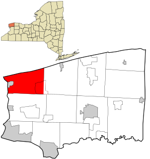
Pendleton is a town on the southern edge of Niagara County, New York, United States. It is east of the city of Niagara Falls and southwest of the city of Lockport. The population was 6,397 at the 2010 census.

Porter, New York Town in New York, United States

Porter is a town in Niagara County, New York, United States. The population was 6,771 at the 2010 census. The town was named after Judge Augustus Porter.

Ransomville, New York CDP in New York, United States

Ransomville is a hamlet located in the Town of Porter in Niagara County, New York, United States. The population was 1,419 at the 2010 census. Portions of the hamlet of Ransomville are also in Town of Wilson and Town of Cambria. Ransomville is north of the City of Niagara Falls and is part of the Buffalo–Niagara Falls Metropolitan Statistical Area.

South Lockport, New York CDP in New York, United States

South Lockport is a hamlet located in the Town of Lockport in Niagara County, New York, United States. The population was 8,234 at the 2010 census. It is part of the Buffalo–Niagara Falls Metropolitan Statistical Area.

Lake Tonawanda

Lake Tonawanda was a prehistoric lake that existed approximately 10,000 years ago at the end of the last ice age, in Western New York, United States.

Interstate 990 (I-990) is an auxiliary Interstate Highway located entirely within the town of Amherst in Erie County, New York, in the United States. It runs in a roughly north–south direction for 6.43 miles (10.35 km) through the southwestern and central parts of Amherst from an interchange with I-290 north of Buffalo to an intersection with New York State Route 263 south of Lockport. The highway serves as a connection between Buffalo, the University at Buffalo, and Lockport. Like I-590 in nearby Rochester, I-990 does not physically meet I-90, its parent Interstate Highway; instead, the highway makes the connection by way of a "sibling" highway (I-290). I-990 is the highest numbered Interstate Highway in the United States.

The Lockport Cave can refer to one of two caverns beneath the city of Lockport, New York. One of the caves formed naturally in the underlying dolomite and limestone bedrocks, whereas the other is a hydraulic raceway constructed in the nineteenth century.

New York State Route 263 highway in New York

New York State Route 263 (NY 263) is a state highway located entirely within the town of Amherst in Erie County, New York, in the United States. It extends from just north of the northeast corner of the city of Buffalo in a roughly northeast direction almost straight to just south of the north county line. The road is named Millersport Highway north of Eggert Road in Amherst for the community at its northern terminus. The section between its southern terminus at U.S. Route 62 (US 62) and the Eggert Road intersection is named Grover Cleveland Highway.

New York State Route 93 highway in New York

New York State Route 93 (NY 93) is a 43.08-mile (69.33 km) state highway in western New York in the United States. The route begins at an intersection with NY 18F in the village of Youngstown and runs in a general northwest–southeast direction across Niagara and Erie counties to its east end at an intersection with NY 5 in the town of Newstead, just south of the village of Akron. NY 93 serves as a connector between several major arterials, including NY 104 in Cambria, NY 31 just west of the city of Lockport, and NY 78 south of the city.

New York State Route 77 highway in New York

New York State Route 77 (NY 77) is a north–south state highway in the western part of New York in the United States. The highway runs for 46.28 miles (74.48 km) across mostly rural areas from an intersection with NY 78 and NY 98 in the Wyoming County town of Java to a junction with NY 31 near the city of Lockport in Niagara County. It connects to several of the region's major east–west roads, including U.S. Route 20 (US 20) and the New York State Thruway. In southwestern Genesee County, the route takes on added importance as it provides the most direct route between the Thruway and Darien Lake, Western New York's largest amusement park.

The Hartland Swamp Wildlife Management Area is a 401-acre (1.62 km2) wildlife management area (WMA) located in western New York, USA. Hartland Swamp WMA is located northeast of Lockport in the Town of Hartland in northeastern Niagara County. It is managed by the New York State Department of Environmental Conservation.

Carlisle Gardens is a hamlet in the town of Lockport in Niagara County, New York, United States.

Shooktown, New York is a hamlet in the town of Lockport in Niagara County, New York, United States.

Wendelville, New York is a hamlet in the town of Pendleton in Niagara County, New York, United States.

References

Coordinates: 43°13′21″N78°40′37″W / 43.22250°N 78.67694°W / 43.22250; -78.67694

Geographic coordinate system Coordinate system

A geographic coordinate system is a coordinate system that enables every location on Earth to be specified by a set of numbers, letters or symbols. The coordinates are often chosen such that one of the numbers represents a vertical position and two or three of the numbers represent a horizontal position; alternatively, a geographic position may be expressed in a combined three-dimensional Cartesian vector. A common choice of coordinates is latitude, longitude and elevation. To specify a location on a plane requires a map projection.