
Brezovo is a small settlement in the Sava Hills in the Municipality of Sevnica in central Slovenia. The area is part of the historical region of Styria. The municipality is now included in the Lower Sava Statistical Region.

Gornje Brezovo is a settlement in the Municipality of Sevnica in central Slovenia. It lies on the left bank of the Sava River east of Sevnica. The area is part of the historical region of Styria. The municipality is now included in the Lower Sava Statistical Region.
Hudo Brezje is a settlement in the hills above the right bank of the Sava River in the western Krško Hills in east-central Slovenia. It belongs to the Municipality of Sevnica. The area is part of the historical region of Lower Carniola and is now included in the Lower Sava Statistical Region.
Lončarjev Dol is a settlement in the hills east of Sevnica in east-central Slovenia. The area is part of the historical region of Styria. The entire Municipality of Sevnica is now included in the Lower Sava Statistical Region.
Lukovec is a small settlement in the Municipality of Sevnica in east-central Slovenia. It lies above the right bank of the Sava River east of Boštanj. The area is part of the historical region of Lower Carniola. The municipality is now included in the Lower Sava Statistical Region.
Metni Vrh is a dispersed settlement in the hills north of Sevnica in east-central Slovenia. The area is part of the historical region of Lower Styria. The Municipality of Sevnica is now included in the Lower Sava Statistical Region.
Otavnik is a settlement southeast of Tržišče in the Municipality of Sevnica in east-central Slovenia. The area is part of the historical region of Lower Carniola. The municipality is included in the Lower Sava Statistical Region.
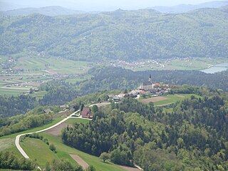
Podgorica is a dispersed settlement in the Municipality of Sevnica in east-central Slovenia. It lies on the slope of Mount Lisca north of Sevnica in the historical region of Styria. The municipality is now included in the Lower Sava Statistical Region.
Prešna Loka is a small settlement in the hills northeast of Sevnica in the historical region of Styria in east-central Slovenia. The Municipality of Sevnica is part of the Lower Sava Statistical Region.
Radež is a settlement in the hills above the left bank of the Sava River in the Municipality of Sevnica in east central Slovenia. The area is part of the historical region of Styria. The municipality is now included in the Lower Sava Statistical Region.

Radna is a settlement in the Municipality of Sevnica in east-central Slovenia. It lies at the confluence of the Mirna River and the Sava River in the historical region of Lower Carniola. The municipality is now included in the Lower Sava Statistical Region.
Razbor is a village below Mount Lisca in the Municipality of Sevnica in east-central Slovenia. The area is part of the historical region of Styria. The municipality is now included in the Lower Sava Statistical Region.

Skrovnik is a small settlement in the Municipality of Sevnica in east-central Slovenia. It lies on the left bank of the Mirna River northeast of Mokronog on the regional road to Tržišče in the historical region of Lower Carniola. The municipality is now included in the Lower Sava Statistical Region.
Slap is a small settlement above the left bank of the Sava River north of Loka pri Zidanem Mostu in the Municipality of Sevnica in east-central Slovenia. The area is part of the historical region of Styria. The municipality is now included in the Lower Sava Statistical Region.
Stržišče is a settlement in the hills northeast of Sevnica in east-central Slovenia. The area is part of the historical region of Styria. The Municipality of Sevnica is now included in the Lower Sava Statistical Region.
Žigrski Vrh is a settlement in the Municipality of Sevnica in central Slovenia. It lies in the hills above the left bank of the Sava River east of Sevnica in the historical region of Styria. The municipality is now included in the Lower Sava Statistical Region.
Vrhek is a settlement in the Municipality of Sevnica in east central Slovenia. It lies in the hills above the left bank of the Mirna River southeast of Krmelj. The area is part of the historical region of Lower Carniola. The municipality is now included in the Lower Sava Statistical Region.

Trščina is a small settlement in the Municipality of Sevnica in east-central Slovenia. It lies in the hills east of Mokronog and south of Tržišče. The area is part of the historical region of Lower Carniola. The municipality is now included in the Lower Sava Statistical Region.

Telče is a settlement east of Tržišče in the Municipality of Sevnica in east-central Slovenia. The area is part of the historical region of Lower Carniola. The municipality is now included in the Lower Sava Statistical Region.
Kamenško is a small village in the Municipality of Sevnica in southeastern Slovenia. It lies on a small rise northeast of Krmelj, east of the road connecting Krmelj and Šentjanž, above and to the north of the villages of Brezje and Kamenica. Until 2001, the area was part of the settlement of Kamenica. The village is part of the traditional region of Lower Carniola and is included in the Lower Sava Statistical Region.


